
Baramulla district or Varmul is one of the 20 districts in the Indian-administered union territory of Jammu and Kashmir in the disputed Kashmir region. Baramulla town is the administrative headquarters of this district. The district covered an area of 4,588 km2 (1,771 sq mi) in 2001, but it was reduced to 4,243 km2 (1,638 sq mi) at the time of 2011 census. In 2016, the district administration said that the area was 4,190 km2 (1,620 sq mi). Muslims constitute about 98% of the population among which Shia Muslims form 30-35% and Sunni Muslims form 65-70%.

Baramulla, also known as Varmul in Kashmiri, is a City and municipality of the Baramulla district of the Indian-administered Jammu and Kashmir in the disputed Kashmir region. It is also the administrative headquarters of the Baramulla district, located on the banks of the River Jhelum downstream from Srinagar, the summer capital of Jammu and Kashmir. The town was earlier known as gateway of Kashmir, serving as the major distribution centre for goods arriving in Kashmir valley through the Jhelum valley cart road.

The Jammu–Baramulla line is a railway track being laid to connect the Kashmir Valley in the Indian union territory of Jammu and Kashmir with Jammu railway station and thence to the rest of the country. The 338 km railway track will start from Jammu and end at Baramulla. It comes under the jurisdiction of the Firozpur railway division of Indian Railways' Northern zone. The 359 m (1,178 ft) tall Chenab Bridge lies on this line, which is the tallest railway bridge in the world. The total project cost in 2022 was INR28,000 crore.

Srinagar railway station is a railway station of the city of Srinagar in the Indian union territory of Jammu and Kashmir.
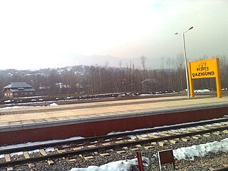
Qazigund railway station lies on Northern Railway network zone of Indian Railways. It is located in Qazigund Jammu and Kashmir, India. It is the main transport hub for the people of Qazigund.
Baramulla Railway Station is situated in outskirts of baramulla town nearly about 5 km from main town. Transport facility is available in working hours from main town baramulla to railway station and vice versa. It is the first station of 130 km long railway line which connects Kashmir Valley with Banihal.

Shri Mata Vaishno Devi Katra railway station is a railway station on the Jammu Udhampur Srinagar Baramulla Railway Link in the Indian Union Territory of Jammu and Kashmir. It mainly serves for the town of Katra where the major hindu divine temple Shri Mata Vaishno Devi is situated which is visited by millions of travellers per month with the help of this station and its frequent special trains connectivity from all over India. The station belongs to the Firozpur division of Northern Railway zone in Jammu and Kashmir.
Hanjiwera is a notified area and village in Singhpora, Pattan, Baramulla district in Indian union territory of Jammu and Kashmir. It is located 31 km (19 mi) to the east from the district headquarters in Baramulla and 23 km (14 mi) from union territory capital, Srinagar.

Anantnag railway station is a railway station on the Northern railway network. It is the headquarters of Anantnag division of Northern Railway zone. It lies in Firozpur division.
Sadura railway station is a railway station on the Northern railway network of India. It is the headquarters of Anantnag division of Northern Railway zone.
Hamray or Hamre is a village in the Pattan tehsil of Baramulla district in Jammu and Kashmir, India, located 7 km away from Pattan town along the Srinagar- Baramulla highway.
Pattan is a sub-district, town and a municipal committee in Baramulla district in the Indian union territory of Jammu and Kashmir.

Banihal railway station, a part of Jammu–Baramulla line, is situated in notified area of Banihal in Ramban district, Jammu and Kashmir. It was commissioned on 26 June 2013 and passenger trains run from Banihal to Qazigund. The station was inaugurated by former prime minister Manmohan Singh and UPA Chairperson Sonia Gandhi on the same day at 2.22 pm. They enjoyed the 12-minute ride in train through Pir Panjal tunnel up to Qazigund with 100 students, mostly girls, of the Banihal Higher Secondary School, and made the 17.8-km ride back to Banihal, passing through the tunnel again, the second longest in Asia.
Awantipora railway station is situated in notified area of Awantipora in the Pulwama district. It is the headquarters of Pulwama division of Northern railway zone. It is one of the four stations in Pulwama district, the others being Pampore railway station, Kakapora railway station and Panchgam railway station respectively.
Bijbiara railway station is a railway station on the Northern Railway network in Anantnag, Jammu and Kashmir. It is the twelfth station on the railway line about 93 km (58 mi) from Baramulla railway station. It is 3 km (1.9 mi) away from the main town.
Budgam railway station is a station on Northern Railway Network of Indian Railways. This station is the headquarter of Jammu–Baramulla line network. It is located in Ompora, a town in Budgam district nearly 2.5 km (1.6 mi) from main town Budgam.

Sopore Railway Station is situated in the outskirts of Sopore town. It lies on Northern Railway Network Zone of Indian Railways. It is one of the northernmost station of Indian Railways.
Pampur railway station is the railway station on the Jammu–Baramulla line in the Indian union territory of Jammu and Kashmir. It is one of the four stations in Pulwama district, the others being Awantipora railway station, Kakapora railway station and Panchgam railway station respectively.
Kakapora railway station is a railway station in the Northern Railway zone of Indian Railways. It is one of the four stations in Pulwama district, others being Awantipora railway station, Pampore railway station and Panzgam railway station respectively.
The Government Degree College Pattan also known as GDC Pattan, Pattan College, is a University of Kashmir affiliated degree college located at Pattan in Baramulla district of Indian administrated state of Jammu and Kashmir.The college is recognised by University Grants Commission of India under sections 2(f) and 12(b) of UGC, Act 1956. The college underwent first cycle of NAAC inspection in November 2021 and was graded 'C' grade with the score of 2.0 on 7 point scale.