
The Brisbane Water National Park is a protected national park that is located in the Central Coast region of New South Wales, in eastern Australia. The 11,506-hectare (28,430-acre) national park is situated 47 kilometres (29 mi) north of Sydney, 10 kilometres (6.2 mi) west of Woy Woy, and 12 kilometres (7.5 mi) southwest of Gosford.

The Royal National Park is a protected national park that is located in Sutherland Shire in the Australian state of New South Wales, just south of Sydney.

The Australian National Botanic Gardens (ANBG) is a heritage-listed botanical garden located in Acton, Canberra, in the Australian Capital Territory, Australia. Established in 1949, the Gardens is administered by the Australian Government's Department of Agriculture, Water and the Environment. The botanic gardens was added to the Commonwealth Heritage List on 22 June 2004.

The Cumberland Plain, an IBRA biogeographic region, is a relatively flat region lying to the west of Sydney CBD in New South Wales, Australia. Cumberland Basin is the preferred physiographic and geological term for the low-lying plain of the Permian-Triassic Sydney Basin found between Sydney and the Blue Mountains, and it is a structural sub-basin of the Sydney Basin.

The Avon Wheatbelt is a bioregion in Western Australia. It has an area of 9,517,104 hectares. It is considered part of the larger Southwest Australia savanna ecoregion.

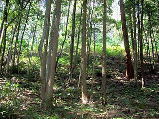
The Sydney Turpentine-Ironbark Forest (STIF) is dry sclerophyll forest community of Sydney, New South Wales, Australia, that is typically found in the Inner West and Northern region of Sydney. It is also among the three of these plant communities which have been classified as Endangered, under the New South Wales government's Threatened Species Conservation Act 1995, with only around 0.5% of its original pre-settlement range remaining.

Western Australia occupies nearly one third of the Australian continent. Due to the size and the isolation of the state, considerable emphasis has been made of these features; it is the second largest administrative territory in the world, after Yakutia in Russia, despite the fact that Australia is only the sixth largest country in the world by area, and no other regional administrative jurisdiction in the world occupies such a high percentage of a continental land mass. It is also the only first level administrative subdivision to occupy the entire continental coastline in one cardinal direction.
The Garawarra State Conservation Area is a protected conservation area that is located on the southern suburban fringe of Greater Sydney, in the state of New South Wales, in eastern Australia. The 949-hectare (2,350-acre) reserve abuts the Royal National Park and is situated 40 kilometres (25 mi) south of the Sydney central business district, near Helensburgh. Garawarra was gazetted as a park in 1987, and added, together with the Royal National Park, to the Australian National Heritage List on 15 September 2006.

Dichelachne crinita , commonly known as the longhair plume grass, is a type of grass found in Australia, New Zealand and islands of the Pacific Ocean. It is often seen on sandy soils near the sea as well as woodlands. The flowering panicles are open and feathery at maturity. The grass may grow up to 1.5 metres (5 ft) tall. Crinita, the specific epithet, is derived from Latin (hairy).

Western Sydney Regional Park is a large urban park and a nature reserve situated in Western Sydney, Australia within the suburbs of Horsley Park and Abbotsbury. A precinct of Western Sydney Parklands, a park system, and situated within the heart of the Cumberland Plain Woodland, the regional park features several picnic areas, recreational facilities, equestrian trails, and walking paths within the Australian bush.
The Cooks River/Castlereagh Ironbark Forest (CRCIF) is a 1,101-hectare (2,721-acre) area of dry sclerophyll open-forest to low woodland which occurs predominantly in the Cumberland subregion of the Sydney basin bioregion, between Castlereagh and Holsworthy, as well as around the headwaters of the Cooks River. The majority of the community is found in the north-west section of the Cumberland Subregion in the Castlereagh area between Penrith and Richmond. Other significant patches occur in the Kemps Creek and Holsworthy areas. Smaller remnants occur in the eastern section of the Cumberland Subregion.
Bangadilly National Park is a national park located around 20 km west of Bowral in the Southern Highlands of New South Wales. Established in 2001, it is made up of three separate, similarly sized areas of land totalling 2,141 hectares in area. It consists of sandstone plateaus and gorges bordering the Wingecarribee River.

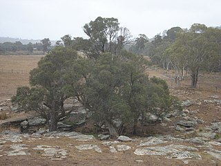
The Cumberland Plain Woodland, or Western Sydney woodland, is a grassy woodland community found predominantly in Western Sydney, New South Wales, Australia, that comprises an open tree canopy, a groundcover with grasses and herbs, usually with layers of shrubs and/or small trees.

The ecology of Sydney, located in the state of New South Wales, Australia, is diverse for its size, where it would mainly feature biomes such as grassy woodlands and some sclerophyll forests, with a few pockets of mallee shrublands, subtropical and temperate rainforests (evergreen), heathlands, and wetlands. The combination of climate, topography, moisture, and soil influence the dispersion of these ecological communities across a height gradient from 0 to 200 metres. There are many hiking trails, paved and unpaved roads for exploring the many different biomes and ecosystems.

Acacia grandifolia is a tree belonging to the genus Acacia and the subgenus Juliflorae that is native to north eastern Australia. It is list as vulnerable according to the Environment Protection and Biodiversity Conservation Act 1999.
The Southern Highlands Shale Forest and Woodland is a mixed grassy woodland and sclerophyll-temperate forest community situated within the Southern Highlands region of New South Wales, Australia. An ecotone featuring clay soils derived from Wianamatta Group, it is listed as an endangered ecological community by the Environment Protection and Biodiversity Conservation Act 1999 as less than 5% of the original extent remains today. Three varieties of the Shale Woodland exist: ‘typical’, ‘tall wet’ and ‘short dry’.

The Blue Mountains and Southern Highlands Basalt Forests are a sclerophyll temperate forest community that stretch from the northern fringes of the Blue Mountains to the Southern Highlands. Featuring both wet and dry sclerophyll forests, as well as small rainforest pockets, the community features tall (30m+) and open eucalypt forests and woodlands that lie on igneous rock.

The Shale Sandstone Transition Forest is a transitory ecotone between the grassy woodlands of the Cumberland Plain Woodlands and the dry sclerophyll forests of the sandstone plateaus on the edges of the Cumberland Plain in Sydney, Australia. Listed in 2001 under the Environment Protection and Biodiversity Conservation Act 1999, the forest lies between other ecological communities found on shale or sandstone substrates.
