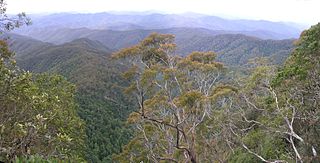
The Brisbane Water National Park is a protected national park that is located in the Central Coast region of New South Wales, in eastern Australia. The 11,506-hectare (28,430-acre) national park is situated 47 kilometres (29 mi) north of Sydney, 10 kilometres (6.2 mi) west of Woy Woy, and 12 kilometres (7.5 mi) southwest of Gosford.

Heathcote National Park is a protected national park that is located in the southern region of Sydney, New South Wales in eastern Australia, and is situated on Dharawal country. The 2,679-hectare (6,620-acre) national park is situated approximately 35 kilometres (22 mi) southwest of the Sydney central business district, west of the South Coast railway line, the Princes Highway and Motorway, and the suburbs of Heathcote and Waterfall.

The Royal National Park is a protected national park that is located in Sutherland Shire in the Australian state of New South Wales, just south of Sydney.

Blue Lake National Park was a former protected area in Queensland, Australia, located on North Stradbroke Island about 44 kilometres (27 mi) east of Brisbane. Blue Lake National Park is now a part of the Naree Budjong Djara National Park. Access was provided by road 9 kilometres (5.6 mi) west of Dunwich.

Sclerophyll is a type of vegetation that is adapted to long periods of dryness and heat. The plants feature hard leaves, short internodes and leaf orientation which is parallel or oblique to direct sunlight. The word comes from the Greek sklēros (hard) and phyllon (leaf). The term was coined by A.F.W. Schimper in 1898, originally as a synonym of xeromorph, but the two words were later differentiated.

Southwest Australia is a biogeographic region in Western Australia. It includes the Mediterranean-climate area of southwestern Australia, which is home to a diverse and distinctive flora and fauna.

Banksia oblongifolia, commonly known as the fern-leaved, dwarf or rusty banksia, is a species in the plant genus Banksia. Found along the eastern coast of Australia from Wollongong, New South Wales in the south to Rockhampton, Queensland in the north, it generally grows in sandy soils in heath, open forest or swamp margins and wet areas. A many-stemmed shrub up to 3 m (9.8 ft) high, it has leathery serrated leaves and rusty-coloured new growth. The yellow flower spikes, known as inflorescences, most commonly appear in autumn and early winter. Up to 80 follicles, or seed pods, develop on the spikes after flowering. Banksia oblongifolia resprouts from its woody lignotuber after bushfires, and the seed pods open and release seed when burnt, the seed germinating and growing on burnt ground. Some plants grow between fires from seed shed spontaneously.

The Cumberland Plain, an IBRA biogeographic region, is a relatively flat region lying to the west of Sydney CBD in New South Wales, Australia. Cumberland Basin is the preferred physiographic and geological term for the low-lying plain of the Permian-Triassic Sydney Basin found between Sydney and the Blue Mountains, and it is a structural sub-basin of the Sydney Basin.

The Sydney Turpentine-Ironbark Forest (STIF) is wet sclerophyll forest community of Sydney, New South Wales, Australia, that is typically found in the Inner West and Northern region of Sydney. It is also among the three of these plant communities which have been classified as Endangered, under the New South Wales government's Threatened Species Conservation Act 1995, with only around 0.5% of its original pre-settlement range remaining.

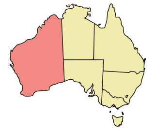
Western Australia occupies nearly one third of the Australian continent. Due to the size and the isolation of the state, considerable emphasis has been made of these features; it is the second largest administrative territory in the world, after Yakutia in Russia, despite the fact that Australia is only the sixth largest country in the world by area, and no other regional administrative jurisdiction in the world occupies such a high percentage of a continental land mass. It is also the only first level administrative subdivision to occupy the entire continental coastline in one cardinal direction.

The Eastern Australian temperate forests is a broad ecoregion of open forest on uplands starting from the east coast of New South Wales in the South Coast to southern Queensland, Australia. Although dry sclerophyll and wet sclerophyll eucalyptus forests predominate within this ecoregion, a number of distinguishable rainforest communities are present as well.

The Southern Sydney sheltered forest, or the Sydney Sandstone Gully Forest (SSGF), is a vegetation community found in Sydney, Australia that comprises an open forest composition grading into woodland or scrub, typically within gullies. The community is normally associated with sheltered heads and upper inclines of gullies on transitional zones where sandstone outcropping may be present. The community also incorporates Western Sandstone Gully Forest to the west and Coastal Sandstone Gully Forest to the east on the infertile Hawkesbury sandstone.

The Hornsby Plateau is a dissected sandstone plateau lying to the north of Sydney Harbour that rises 200 metres. The plateau is a part of the larger Sydney Basin structure.

The Cumberland Plain Woodland, or Western Sydney woodland, is a grassy woodland community found predominantly in Western Sydney, New South Wales, Australia, that comprises an open tree canopy, a groundcover with grasses and herbs, usually with layers of shrubs and/or small trees.

The ecology of Sydney, located in the state of New South Wales, Australia, is diverse for its size, where it would mainly feature biomes such as grassy woodlands or savannas and some sclerophyll forests, with some pockets of mallee shrublands, riparian forests, heathlands, and wetlands, in addition to small temperate rainforest fragments.
Wide Bay Military Reserve is a heritage-listed military installation at Tin Can Bay Road, Tin Can Bay, Queensland, Australia. The reserve supports a diverse range of plant communities from estuarine, strand, wetlands, heath, tall shrublands and woodlands, to the open forests of the sub-coastal hills and ranges. The total number of bird species recorded for the place totals 250, which is high by Australian standards. It was added to the Australian Commonwealth Heritage List on 22 June 2004.

The Shale Sandstone Transition Forest, also known as Cumberland Shale-Sandstone Ironbark Forest, is a transitory ecotone between the grassy woodlands of the Cumberland Plain Woodlands and the dry sclerophyll forests of the sandstone plateaus on the edges of the Cumberland Plain in Sydney, Australia.

The Elderslie Banksia Scrub Forest is a critically endangered scrubby woodland situated in southwestern Sydney, New South Wales, Australia. Listed under the Environment Protection and Biodiversity Conservation Act 1999, it is a variety of stunted forest or woodland found on sandy substrates associated with deep Tertiary sand deposits, which has been reduced in extent of at least 90% of its original pre-European extent.

The Eastern Suburbs Banksia Scrub, which also incorporates Sydney Coastal Heaths, is a remnant sclerophyll scrubland and heathland that is found in the eastern and southern regions of Sydney, New South Wales, Australia. Listed under the Environment Protection and Biodiversity Conservation Act 1999 as and endangered vegetation community and as 'critically endangered' under the NSW Biodiversity Conservation Act 2016, the Eastern Suburbs Banksia Scrub is found on ancient, nutrient poor sands either on dunes or on promontories. Sydney coastal heaths are a scrubby heathland found on exposed coastal sandstone plateau in the south.


