
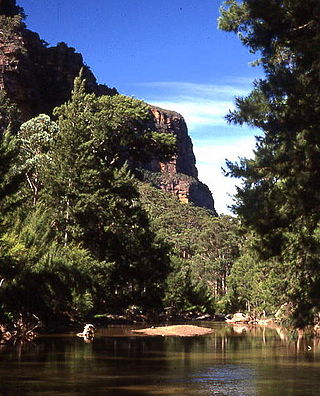
The Blue Mountains are a mountainous region and a mountain range located in New South Wales, Australia. The region is considered to be part of the western outskirts of the Greater Sydney area. The region borders on Sydney's main metropolitan area, its foothills starting about 50 kilometres (31 mi) west of centre of the state capital, close to Penrith. The public's understanding of the extent of the Blue Mountains is varied, as it forms only part of an extensive mountainous area associated with the Great Dividing Range. As defined in 1970, the Blue Mountains region is bounded by the Nepean and Hawkesbury rivers in the east, the Coxs River and Lake Burragorang to the west and south, and the Wolgan and Colo rivers to the north. Geologically, it is situated in the central parts of the Sydney Basin.

The Blue Mountains National Park is a protected national park that is located in the Blue Mountains region of New South Wales, in eastern Australia. The 267,954-hectare (662,130-acre) national park is situated approximately 80 kilometres (50 mi) west of the Sydney CBD, and the park boundary is quite irregular as it is broken up by roads, urban areas and areas of private property. Despite the name mountains, the area is an uplifted plateau, dissected by a number of larger rivers. The highest point in the park is Mount Werong at 1,215 metres (3,986 ft) above sea level; while the low point is on the Nepean River at 20 metres (66 ft) above sea level as it leaves the park.
The Wollemi National Park is a protected national park and wilderness area that is located in the Central West and Hunter region of New South Wales, in eastern Australia. The 501,703-hectare (1,239,740-acre) park, the second largest national park in New South Wales, contains the 361,113-hectare (892,330-acre) Wollemi Wilderness – the largest such wilderness area in Australia – and is situated approximately 130 kilometres (81 mi) northwest of Sydney.

Daarrba National Park (Cape York Peninsula Aboriginal Land) is a national park in Queensland, Australia. It is 1,602 km northwest of Brisbane. The national park was previously named Mount Webb National Park until it was renamed on 28 November 2013.

Sclerophyll is a type of vegetation that is adapted to long periods of dryness and heat. The plants feature hard leaves, short internodes and leaf orientation which is parallel or oblique to direct sunlight. The word comes from the Greek sklēros (hard) and phyllon (leaf). The term was coined by A.F.W. Schimper in 1898, originally as a synonym of xeromorph, but the two words were later differentiated.

The Greater Blue Mountains Area is a World Heritage Site located in the Blue Mountains of New South Wales, Australia. The 1,032,649-hectare (2,551,730-acre) area was placed on the World Heritage List at the 24th Session of the World Heritage Committee, held in Cairns in 2000.

The Cumberland Plain, also known as Cumberland Basin, is a relatively flat region lying to the west of Sydney CBD in New South Wales, Australia. An IBRA biogeographic region, Cumberland Basin is the preferred physiographic and geological term for the low-lying plain of the Permian-Triassic Sydney Basin found between Sydney and the Blue Mountains, and it is a structural sub-basin of the Sydney Basin.

The Eastern Australian temperate forests is a broad ecoregion of open forest on uplands starting from the east coast of New South Wales in the South Coast to southern Queensland, Australia. Although dry sclerophyll and wet sclerophyll eucalyptus forests predominate within this ecoregion, a number of distinguishable rainforest communities are present as well.
Tasmania can be broadly divided into two distinct regions, eastern and western, that exhibit major differences in climate, geology and vegetation. This divide, termed Tyler’s Corridor, runs from just south of the northwestern corner, and continues south, cutting roughly down the center of the island. The vegetation changes occur principally due to variations in soil types, which are a result of the geological composition, and the vast difference in climate across the state. Generally, the west has a higher mean rainfall but poor acidic soil while the east has a lower mean rainfall but slightly more fertile soil. This results in a larger proportion of rainforest, moorland and wet sclerophyll vegetation dominating in the west and predominantly dry sclerophyll in the east.

Blue Mountains Basalts are igneous rocks occurring in the Sydney Basin in eastern Australia. This formation is up to 140 metres thick. Formed in the middle Miocene, some 17 million to 14 million years ago.

The Cumberland Plain Woodland, also known as Cumberland Plain Bushland and Western Sydney woodland, is a grassy woodland community found predominantly in Western Sydney, New South Wales, Australia, that comprises an open tree canopy, a groundcover with grasses and herbs, usually with layers of shrubs and/or small trees.

The Sydney Sandstone Ridgetop Woodland, also known as Coastal Sandstone Ridgetop Woodland and Hornsby Enriched Sandstone Exposed Woodland, is a shrubby woodland and mallee community situated in northern parts of Sydney, Australia, where it is found predominantly on ridgetops and slopes of the Hornsby Plateau, Woronora Plateau and the lower Blue Mountains area. It is an area of high biodiversity, existing on poor sandstone soils, with regular wildfires, and moderate rainfall.

The ecology of Sydney, located in the state of New South Wales, Australia, is diverse for its size, where it would mainly feature biomes such as grassy woodlands or savannas and some sclerophyll forests, with some pockets of mallee shrublands, riparian forests, heathlands, and wetlands, in addition to small temperate rainforest fragments.
The Southeast Australia temperate forests is a temperate broadleaf and mixed forests ecoregion of south-eastern Australia. It includes the temperate lowland forests of southeastern Australia, at the southern end of the Great Dividing Range. Vegetation ranges from wet forests along the coast to dry forests and woodlands inland.
The Tasmanian temperate forests is a temperate broadleaf and mixed forests ecoregion in Australia. The ecoregion occupies the eastern portion of the island of Tasmania, which lies south of the Australian mainland.
The Southern Highlands Shale Forest and Woodland is a mixed grassy woodland and sclerophyll-temperate forest community situated within the Southern Highlands region of New South Wales, Australia. An ecotone featuring clay soils derived from Wianamatta Group, it is listed as an endangered ecological community by the Environment Protection and Biodiversity Conservation Act 1999 as less than 5% of the original extent remains today. Three varieties of the Shale Woodland exist: ‘typical’, ‘tall wet’ and ‘short dry’.

The Shale Sandstone Transition Forest, also known as Cumberland Shale-Sandstone Ironbark Forest, is a transitory ecotone between the grassy woodlands of the Cumberland Plain Woodlands and the dry sclerophyll forests of the sandstone plateaus on the edges of the Cumberland Plain in Sydney, Australia.

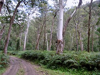
The Blue Mountains Shale Cap Forest is a wet-sclerophyll temperate forest community predominantly found in the Blue Mountains, particularly in the Wollemi National Park, and parts of the Hawkesbury in New South Wales, Australia.


