Related Research Articles
Ashley is a census-designated place in Pike County, Missouri, United States. It is located on Route 161, approximately six miles south of Bowling Green.
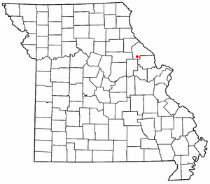
New Hartford is an unincorporated community in southern Pike County, Missouri, United States. It is located on Route 161, approximately fourteen miles south of Bowling Green.
Template:Unincorporated community in Missouri, United States Booth is an extinct town in Pike County, in the U.S. state of Missouri.
Template:Unincorporated community in Missouri, United States Busch is an extinct town in Pike County, in the U.S. state of Missouri. The GNIS classifies it as a populated place.
Calumet is an unincorporated community in eastern Pike County, in the U.S. state of Missouri. The community is located at the intersection of Missouri routes N and D about six miles southwest of Clarkesville and six miles north of Eolia. Calumet Creek flows past to the south of the community.
Cyrene is an unincorporated community in southeast Pike County, in the U.S. state of Missouri. The community is on US Route 61 approximately six miles southeast of Bowling Green.
Edgewood is an unincorporated community in southeast Pike County, in the U.S. state of Missouri. The community lies on Missouri Route WW one half mile esat of US Route 61. Eolia is approximately 4.5 miles to the southeast along Route 61.
Estes is an unincorporated community in southwestern Pike County, in the U.S. state of Missouri. The community is on Missouri Route Y approximately eleven miles southwest of Bowling Green. The elevation of Estes is 738 feet.
Farmer is an unincorporated community in Pike County, in the U.S. state of Missouri.
Gazette is an unincorporated community in southwest Pike County, in the U.S. state of Missouri. The community is located approximately 6.5 miles west of New Hartford. The Pike-Audrain county line is 1.3 miles to the west along Missouri Route K.
McCune is an unincorporated community in Pike County, in the U.S. state of Missouri.
New Harmony is an unincorporated community in western Pike County, in the U.S. state of Missouri. The community is on a county road just east of Missouri Route V about six miles east of Vandalia and four miles south-southeast of Curryville.
Reading is an extinct town in Pike County, in the U.S. state of Missouri. The GNIS classifies it as a populated place.
Stark is an unincorporated community in Pike County, in the U.S. state of Missouri.
Vera is an unincorporated community in Pike County, in the U.S. state of Missouri. The community is located 5.5 miles northeast of Bowling Green along US Route 54. Noix Creek flows past the north side of the community.
Ashley Township is an inactive township in Pike County, in the U.S. state of Missouri.
Cuivre Township is an inactive township in Pike County, in the U.S. state of Missouri.
Indian Township is an inactive township in Pike County, in the U.S. state of Missouri.
Prairieville is an extinct town in Pike County, in the U.S. state of Missouri. The exact location of the town site is unknown to the GNIS. The town is near 39°16′15″N91°00′09″W.
Spencer Township is an inactive township in Pike County, in the U.S. state of Missouri.
References
- 1 2 U.S. Geological Survey Geographic Names Information System: Spencerburg
- ↑ "Pike County Place Names, 1928–1945". The State Historical Society of Missouri. Archived from the original on June 24, 2016. Retrieved December 7, 2016.
- ↑ "Post Offices". Jim Forte Postal History. Retrieved 7 December 2016.
Municipalities and communities of Pike County, Missouri, United States | ||
|---|---|---|
| Cities |  | |
| Villages | ||
| Townships | ||
| CDPs | ||
| Unincorporated communities | ||
| Ghost towns | ||
Coordinates: 39°25′18″N91°23′16″W / 39.42167°N 91.38778°W
| | This Pike County, Missouri state location article is a stub. You can help Wikipedia by expanding it. |