St. Thomas is a city in southwestern Ontario, Canada. It gained its city charter on March 4, 1881. The city is also the seat for Elgin County, although it is independent of the county.
The city, located at the intersection of two historical roads, was first settled in 1810. It was named the seat of the new Elgin County in 1844 and was incorporated as a village in 1852, then as a town in 1861. In 1881 St. Thomas became a city. It was named after Thomas Talbot[4] who helped promote the development of this region during the early 19th century.
The founder of the settlement that became St. Thomas was Capt. Daniel Rapelje, descendant of a Walloonfamily settled in New Amsterdam, now New York City, at its inception in the seventeenth century.[5] In 1820, Rapelje, the town's first settler, divided his land into town lots suitable for a village. Owner of the New England Mill, Rapelje subsequently donated two acres of land for the building of Old St. Thomas Church.[6]
In 1871, the developing village of Millersburg, which included these lands east of the London and Port Stanley Railway, amalgamated with St. Thomas.[7]
In the late 19th century and early 20th century several railways were constructed through the city, and St. Thomas became an important railway junction. A total of 26 railways have passed through the city since the first railway was completed in 1856. In the 1950s and 1960s, with the decline of the railway as a mode of transportation, other industry began to locate in the city, principally primary and secondary automotive manufacturing.
Jumbo the circus elephant, said to be the world's biggest elephant at the time, died here on September 15, 1885, shortly after being hit by a locomotive. There is a life-sized commemorative statue that was erected in 1985.
In 1824, Charles Duncombe and John Rolph established the first medical school in Upper Canada, in St. Thomas, under the patronage of Colonel Thomas Talbot.[8] Duncombe's house now forms part of The Elgin Military Museum complex. Between 1881 and 1988 the city had a private woman's school operating called Alma College which was destroyed by fire in 2008.
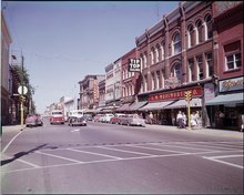
St. Thomas' late 19th- early 20th century architecture includes the Elgin County Court House, Wellington Street public school, Myrtle St. School (demolished in 2014), Balaclava St. School, Elmdale School and its city hall, most designated heritage properties and all designed by former resident Neil R. Darrach.
Government
Joe Preston is the current mayor of St. Thomas. The City Council consists of the mayor and eight City Councillors, all elected at large, meaning Councillors are elected on a citywide basis.[9]
Military
31 Combat Engineer Regiment (The Elgins) was created in 1997 when the former Elgin Regiment (RCAC) was re-roled from an armour tasking. The regiment had been associated with St. Thomas since its creation; St. Thomas is currently home to one of its two component field squadrons.[10] St. Thomas Armoury is a recognized Federal Heritage building 1992 on the Register of the Government of Canada Heritage Buildings.[11]
Demographics
In the 2021 Census of Population conducted by Statistics Canada, St. Thomas had a population of 42,840 living in 18,062 of its 18,596 total private dwellings, a change of 10.1% from its 2016 population of 38,909. With a land area of 35.61km2 (13.75sqmi), it had a population density of 1,190/km2 (3,082/sqmi) in 2021.[12]
According to the 2011 census, St. Thomas had a population of 37,905 people in 2011, which was an increase of 5.6% from the 2006 census count. The median household income in 2016 for St. Thomas was $71,356.75[13]
In the 2016 Census, more than 10,000 people were age 60 or over.[14]
The local economy has been dominated by automotive manufacturing, with two plants operated by Magna International, the FordSt. Thomas Assembly in nearby Talbotville, and a Sterling Trucks assembly plant. However, the 2008 global recession that impacted the auto sector ultimately trickled down to the city; the Sterling plant closed in March 2009, and the Ford plant closed in late 2011 for a loss of 1,400 jobs.[16] A number of other, smaller auto parts plants also closed as a result, putting thousands more out of work. This had a domino effect on the other part manufacturers in town, such as Lear Seating. One automotive materials supplier, A. Schulman, had previously closed its local manufacturing plant in 2008, one of the first actions of a new CEO installed in January.[17]
Masco Canada's consolidation of their Canadian operations into the former Sterling Truck assembly plant in 2010[18] and Toyota supplier Takumi Stamping Canada's expansion in the same year[19] brought over 500 jobs to St. Thomas.
A report in June 2019 indicated that a plant for cross-laminated timber (CLT) would be built in town, providing over 60 jobs. The estimated cost of the automated plant was $32 million.[20]
The town's Economic Development Corporation has attracted film crews,[21] particularly to the former psychiatric hospital (the Regional Mental Health Centre) on Sunset Drive as a location for filming. A January 2020 report indicated that productions filming in the town have included The Boys, Guillermo del Toro's Scary Stories to Tell in the Dark and most recently, a film featuring Jason Momoa that was planning to film in town, frequently outdoors, from February to June 2020.[22][23]
In April 2023 an announcement was made for the building of a battery plant by PowerCo, a subsidiary of Volkswagen AG and to have it running by 2027.[24] This plant is expected to employ 3,000 and be one of the largest VW plants in the world.
Transportation
The Highway 4 / Talbot Street (now renamed Talbot Hill) junction, before it was reconstructed into a roundabout.
The city is served by the St. Thomas Municipal Airport (YQS), just east in the Municipality of Central Elgin. There are no scheduled flights; the airport is used for general aviation only. A bi-annual large-scale air show takes place at the St. Thomas Municipal Airport.
St. Thomas has several media outlets based in the city. The St. Thomas Times-Journal is the city's newspaper, owned by Sun Media (Quebecor). The St. Thomas - Elgin Weekly News is a weekly newspaper published in St. Thomas, that is distributed for free to all residents of St. Thomas and Elgin County. The Elgin County Market is a weekly publication that is also distributed for free to all residents of St. Thomas and Elgin County, it features various local business flyers and advertisements.
Rogers Cable operates a local community channel consisting mostly of local and dedicated volunteers. CFPL-DT, branded as CTV Two London, covers many news stories from St. Thomas.
St. Thomas's only local commercial radio station, CKZM-FM 94.1 FM was launched on May 20, 2011. Also a low-power FM radio station — VF8016, 90.1 MHz— broadcasts religious activities from Faith Baptist Church of St. Thomas. CFHK-FM, branded as 103.1 Fresh FM, is also licensed to St. Thomas, although its programming originates from London and targets all of southwestern Ontario.
Establish Media is the newest media outlet based in St. Thomas. They produce digital content which they distribute primarily through social channels.
There are two major parks in the city: Pinafore Park in the south, beside Pinafore Lake; and Waterworks Park in the north, which is straddled by Kettle Creek and the Waterworks Reservoir nearby.
The Lions Club Dog Park is located at the far west end of main street, at 25 Talbot Road. The park is managed by the St. Thomas Dog Owners Association (STDOA) in partnership with the City of St. Thomas. The park is open from dawn to dusk, daily.
The Kettle Creek Dog Park, opened in July 2014, is located just north of St Thomas, off Highbury on Mapleton Line, 200 metres beyond Dan Paterson Conservation Area. The park is open daily from dawn to dusk and boasts a large fenced in park, a fenced-in area for small dogs and a separate fenced-in area for one-on-one play. The park is managed by Kettle Creek Conservation Authority in partnership with STDOA, the Municipality of Central Elgin and the City of St Thomas.
V.A. Barrie Park, located on Sunset Drive, and Waterworks Park include popular Disc Golf courses.
Cultural activities
The Elgin Military Museum is located in the west end of St. Thomas. While the museum recounts the stories of Elgin County residents from the War of 1812 to Afghanistan, it also includes two M113 Armoured Personnel Carriers and a collection of some 600 UN and NATO badges described by one appraiser as "the best collection I have seen outside of the UN in New York". In late 2009, The Elgin Military Museum began the process to acquire the Cold War Oberon Class Submarine HMCS Ojibwa, The submarine is planned to be stationed outside of St. Thomas in Port Burwell.[citation needed]
St. Thomas is also home to the North America Railway Hall of Fame, which is located in the CASO train station. The station was built in the 1870s and was a centre of travel between New York City and Chicago.[citation needed] It is located on Talbot Street downtown.
The Elgin Theatre Guild is located at 40 Princess Avenue, and is home to a thriving community theatre, as well as hosting small musical groups. The building is a former church, built in 1907 by architect Neil Darrach. In 2001, St. Thomas City Council designated 40 Princess Avenue as a building of historic and architectural value in the City of St. Thomas.[citation needed]
St. Thomas is home to the Railway City Brewing Company, one of 29 members of the Ontario Craft Brewers.
As a county seat and major railway junction, St. Thomas was an important and vibrant town in early Ontario. As such, the city has a significant number of pre-1914 heritage buildings.
Public
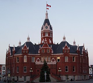
St. Thomas Town Hall, 1899 (545 Talbot St.)
Elgin County Courthouse, 1898 (4 Wellington St.)
St. Thomas Carnegie Library, 1904 (9 Mondamin St.)
Elgin County Registry Office, 1874 (Gladstone Ave.)
St. Thomas Armoury, 1901 (40 Wilson Ave.)
Public Utilities Commission Building, 1916 (36 St. Catherine St.)
Religious
St. Thomas Anglican, 1823 (55 Walnut St)
Trinity Anglican, 1877 (55 Southwick St.)
St. John's Anglican, 1909 (20 Flora St.)
Knox Presbyterian, 1883 (55 Hincks St.)
Alma Street Presbyterian, 1891 (94 Kains St.)
Central Methodist, 1897 (135 Wellington St.)
Holy Angels Roman Catholic, 1911 (502 Talbot Street)
Centre Street Baptist, 1879 (28 Southwick St.)
Church of Christ, 1906 (40 Princess Ave.)
Education
Wellington Street Public School, 1898 (50 Wellington St.)
Balaclava Street School, 1898 (20 Balaclava St.)
Arthur Voaden Vocational School, 1925 (41 Flora St.)
Brampton is a city in the Canadian province of Ontario. It is part of the Greater Toronto Area (GTA) and is a lower-tier municipality within Peel Region. The city has a population of 656,480 as of the 2021 Census, making it the ninth most populous municipality in Canada and the third most populous city in the Greater Golden Horseshoe urban area, behind Toronto and Mississauga.
Prescott is a town on the north shore of the Saint Lawrence River in province of Ontario, Canada. The town is a part of the United Counties of Leeds and Grenville. In 2021, it had a population of 4,078. The Ogdensburg–Prescott International Bridge, 5 kilometres (3.1 mi) east of Prescott at Johnstown, crosses the Canada–United States border and connects the town with the city of Ogdensburg, New York.
Guelph is a city in Southwestern Ontario, Canada. Known as The Royal City, it is roughly 22 km (14 mi) east of Kitchener and 70 km (43 mi) west of Downtown Toronto, at the intersection of Highway 6, Highway 7 and Wellington County Road 124. It is the seat of Wellington County, but is politically independent of it.
Aurora is a town in central York Region in the Greater Toronto Area, within the Golden Horseshoe of Southern Ontario, Canada. It is located north of the City of Richmond Hill and is partially situated on the Oak Ridges Moraine. In the Canada 2021 Census, the municipal population of Aurora was the 92nd largest in Canada, compared to 95th for the 2016 Census and 97th for the 2006 Census. Aurora is twinned with Leksand, Sweden.
Woodstock is a city in Southwestern Ontario, Canada. The city has a population of 46,705 according to the 2016 Canadian census. Woodstock is the seat of Oxford County, at the head of the Thames River, approximately 128 km from Toronto, and 43 km from London, Ontario. The city is known as the Dairy Capital of Canada and promotes itself as "The Friendly City".
Stratford is a city on the Avon River within Perth County in southwestern Ontario, Canada, with a 2021 population of 33,232 in a land area of 30.02 square kilometres (11.59 sq mi). Stratford is the seat of Perth County, which was settled by English, Irish, Scottish and German immigrants, in almost equal numbers, starting in the 1820s but primarily in the 1830s and 1840s. Most became farmers; even today, the area around Stratford is known for mixed farming, dairying and hog production.
Caledonia is a community located on the Grand River in Haldimand County, Ontario, Canada. It had a population of 12,179 as of the 2021 Canadian Census. Caledonia is within Ward 3 of Haldimand County. The Councillor elected for Ward 3 is Dan Lawrence. As of 2021, there were 4,310 private dwellings in Caledonia.
Norfolk County is a rural single-tier municipality on the north shore of Lake Erie in Southwestern Ontario, Canada with a 2016 population of 67,490. Despite its name, it is no longer a county by definition, as all municipal services are handled by a single level of government. The largest community in Norfolk County is Simcoe, whose 2016 population was 13,922. The other population centres are Port Dover, Delhi, Waterford and Port Rowan, and there are many smaller communities. For several years in the late 20th century, the county was merged with Haldimand County but the merged entity was dissolved in 2000.
Collingwood is a town in Simcoe County, Ontario, Canada. It is situated on Nottawasaga Bay at the southern point of Georgian Bay. Collingwood is well known as a tourist destination, for its skiing in the winter, and limestone caves along the Niagara Escarpment in the summer.
Tillsonburg is a town in Oxford County, Ontario, Canada with a population of 18,615 located about 50 kilometres southeast of London, on Highway 3 at the junction of Highway 19.
St. Marys is a town in southwestern Ontario, Canada. It is located at the confluence of the north branch of the Thames River and Trout Creek southwest of Stratford, and is surrounded by the Township of Perth South in Perth County, Ontario. St. Marys operates under its own municipal government that is independent from the county's government. Nonetheless, the three entities "enjoy a large degree of collaboration and work together to grow the region as a leading location for industry and people". Census data published for Perth County by Statistics Canada includes St. Marys and most Perth County publications also do, at least in some sections of the document.
Fergus is the largest community in Centre Wellington, a township within Wellington County in Ontario, Canada. It lies on the Grand River about 18 km NNW of Guelph. The population of this community at the time of the 2016 Census was 20,767, but the community is growing as new homes are being built for sale.
Renfrew is a town on the Bonnechere River in Renfrew County, Ontario, Canada. Located one hour west of Ottawa in Eastern Ontario, Renfrew is the fourth largest town in the county after Petawawa, Pembroke and Arnprior. The town is a small transportation hub connecting Highway 60 and Highway 132 with the Trans-Canada Highway. Renfrew is also known historically for its role in the formation of the National Hockey League. It lies about 5 kilometres from the Quebec border, about 10 kilometres by road. Renfrew makes most of Canada’s hockey tape.
Elgin County is a county of the Canadian province of Ontario with a 2016 population of 50,069. Its population centres are St. Thomas, Aylmer, Port Stanley, Belmont, Dutton and West Lorne. The county seat is St. Thomas, which is separated from the county but within its geographic boundary.
Thomas Talbot was an Irish-born Canadian soldier and colonial administrator. He founded the community of Port Talbot, Ontario, which was at one time the most prosperous town in the region due to his insistence on building quality roads, and was responsible for enticing 50,000 people to settle in the Thames River area.
Port Stanley is a community in the Municipality of Central Elgin, Elgin County in Ontario, Canada. It is located on the north shore of Lake Erie at the mouth of Kettle Creek. In 2016, it had a population of 2,148.
Southampton is a community on the shores of Lake Huron in Bruce County, Ontario, Canada. It is close to Port Elgin and is located at the mouth of the Saugeen River in the Saugeen Ojibway Nation Territory. The size of the town is 6.44 square kilometres. The permanent population in 2016 was 3,678, but the summer population is higher since cottagers and campers spend vacation time in the area.
Southwestern Ontario is a secondary region of Southern Ontario in the Canadian province of Ontario. It occupies most of the Ontario Peninsula bounded by Lake Huron, including Georgian Bay, to the north and northwest; the St. Clair River, Lake St. Clair, and Detroit River, to the west; and Lake Erie to the south. To the east, on land, Southwestern Ontario is bounded by Central Ontario and the Golden Horseshoe. The region had a population of 2,796,367 in 2021.
The London and Port Stanley Railway was a Canadian railway located in southwestern Ontario. It linked the city of London with Port Stanley on the northern shore of Lake Erie, a distance of approximately 25 miles (40 km).
Built between 1822 and 1824, the St. Thomas Anglican Church, today called the Old St. Thomas Church, is one of the oldest structures in St. Thomas, Ontario The Church was continuously used between its founding and 1877. The church was made a designated heritage property in 1982.
This page is based on this Wikipedia article Text is available under the CC BY-SA 4.0 license; additional terms may apply. Images, videos and audio are available under their respective licenses.