St Abb's Head

Last updated

St Abb's Head National Nature Reserve
IUCN category IV (habitat/species management area) [1]
St Abbs Head from St Abbs.jpg
St Abb's Head seen from the south near the village of St Abbs
Scottish Borders UK relief location map.jpg
Red pog.svg
Location with the Scottish Borders
Scotland relief location map.jpg
Red pog.svg
Location in Scotland
Location Scottish Borders, Scotland
Coordinates 55°54′57.9″N2°08′19.0″W / 55.916083°N 2.138611°W / 55.916083; -2.138611 Coordinates: 55°54′57.9″N2°08′19.0″W / 55.916083°N 2.138611°W / 55.916083; -2.138611
Area77.2 ha (191 acres) [2]
Designation NatureScot
Established1984 [1]
Owner National Trust for Scotland
St Abb's Head National Nature Reserve

St Abb's Head is a rocky promontory by the village of St Abbs in Scottish Borders, Scotland, and a national nature reserve administered by the National Trust for Scotland. St Abb's Head Lighthouse was designed and built by the brothers David Stevenson and Thomas Stevenson and began service on 24 February 1862. [3]

Contents

Geology

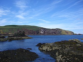
The layered sedimentary rocks of greywacke and siltstone which lie to the north and south of the Head were laid down at the bottom of the sea between 460 and 410 million years ago. The Head itself is made from hard volcanic rock which formed as lava flowed from volcanoes around 400 million years ago. The different type of rocks accounts for the contrast in colour between the rocks of the Head and those of mainland cliffs. The softer sedimentary rocks have eroded over time, leaving behind the high headland made from the harder rock. However even this tough volcanic rock has been affected by the actions of the sea, leaving steep gullies and sea stacks which are ideal for nesting seabirds. The harder rocks of the Head are separated from the sedimentary rock to the southwest by the northwest slanting St Abb's Head Fault, which is marked by a low lying valley which contains the man made Mire Loch and at times of higher sea level would have been flooded, cutting off the headland from the mainland. [4]

Flora and fauna

St Abb's Head is home to a 60,000 strong seabird colony.[ citation needed ] Guillemots and razorbills nest on the offshore stacks, with guillemots nesting together in tightly packed crowds whilst razorbills prefer to nest in single pairs or in smaller groups. Kittiwakes breed on the sheer cliff faces of St Abb's Head, building nests from grass and mud on narrow ledges, whilst fulmars prefer grass-covered ledges and crevices. Shags, herring gulls and puffins are also present. Although best known for its seabirds, the reserve also has flower rich grasslands and a freshwater loch. [5] To preserve the marine habitat, the NTS in conjunction with the Scottish Wildlife Trust, the local fishing community and diving clubs, have set up a Voluntary Marine Reserve which stretches south down the coast to the town of Eyemouth. [6]

The grazing on the Head is leased by the Trust to Northfield Farm which stands just to the south of the Head near St Abbs village. The grassland is surprisingly rich for a coastal situation, in some places it is possible to find over 20 different species of plant in one square metre. There are at least 10 different kinds of butterfly on the Head including the northern brown argus which is a nationally rare butterfly in the UK. The butterflies drink nectar from the flowers of the wild thyme and the caterpillars eat the leaves of rock rose, the areas in which these two plants grow are protected from sheep grazing by fencing. Just inland from the lighthouse is Mire Loch, a 600-metre-long (2,000 ft) artificially created lake. [5]

History

Kirk Hill (centre), the site of St. AEbbe's monastery, with the tip of the Head beyond. Kirk Hill, St Abbs Head 1.jpg
Kirk Hill (centre), the site of St. Æbbe's monastery, with the tip of the Head beyond.

Just 0.5 km to the SE of the lighthouse is Kirk Hill. On the summit of this hill are the remains of the 7th century monastery settlement of Saint Æbbe. About AD 643 Æbbe established the monastery on Kirk Hill within the remains of a 6th-century fort known as Urbs Coludi (Colud's Fort). Both monks and nuns lived at the monastery in basic beehive huts made from mud and branches. Æbbe remained as abbess until her death around 680, a few years later the monastery was accidentally burned down and was not replaced. The settlement was protected by a massive three-metre-high (9.8 ft) turf rampart on the landward side, the remains of this rampart can be seen as a low ridge around the rim of the hill. These are the only remnants of the 7th-century monastic settlement of Æbbe. However, there are faint outlines of buildings, field boundaries and a rectangular burial site dating from the 12th century. These are the scant traces of a Benedictine chapel established in 1188 and dedicated to Æbbe by monks from Coldingham Priory.[ citation needed ]

On the north side of the Head is Pettico Wick Bay this provides a natural trap for salmon as they swim down the coast. A fishing station was established here in 1880 and lasted until around 1950. A jetty was also built in the bay so supplies could be landed for the lighthouse.[ citation needed ]

A signal station was established on the cliffs before 1820 and the facilities were shared by Trinity House and Her Majesty's Coastguard. The Northern Lighthouse Board recommended the building of a lighthouse at St Abb's Head after the sinking of the "Martello" on Carr Rock in 1857. The lighthouse was designed and built by the brothers David Stevenson and Thomas Stevenson and assisted navigation before and after sight of the Bell Rock and Isle of May lights disappeared from view. The light began service on 24 February 1862 and initially used oil to generate its light, it was converted to incandescent power in 1906 and to electricity in 1966 and finally automated in 1993. Before automation the lighthouse was staffed by three full-time keepers whose duties included keeping detailed weather records. [3]

Despite the lighthouse, several ships have been lost on the jagged coastline off St Abbs. The cargo ship MV Nyon ran aground on 16 November 1958 in dense fog. The crew was rescued ship was beached on rocks but the stern was successfully separated and salvaged, eventually towed to the Netherlands where it was rebuilt with a new front section. The Nyon's original bow section remained at St Abbs until it was destroyed by wave action.

Royal Navy Scout Cruiser HMS Pathfinder, the first vessel to be destroyed by a self-propelled torpedo, sunk off St Abbs Head on 5 September 1914 with the loss of 259 lives, having been attacked by German U-boat, SM U-21. The explosion that destroyed the ship was witnessed by author Aldous Huxley who was staying in St Abbs at the time.

Visitor facilities

St Abbs Visitor Centre St Abbs Visitor Centre.JPG
St Abbs Visitor Centre

The NTS has an information point for St Abb's Head located at Northfield Farm which has an exhibition with information about the Head, coffee shop, art gallery and textile shop. There are maps describing the walk to the Head and as well as Ranger led guided walks. [5]

March 2011 saw the opening of the latest addition to the many attractions of St Abbs in the form of the new St Abbs Visitor Centre. This facility is located in St Abbs old village hall, located at the cliff edge. Built as a resource for both visitors and locals, the centre offers free admission, interactive exhibits, library area, web access, photographs and historical artefacts. It provides visitors with information on the history of the village, the geology and also the local flora and fauna they are may encounter. The position of the building offers a 180-degree view from St Abb's Head all the way to the harbour and beyond. The centre is run by an independent Scottish charity. [7]

Conservation designations

Land around St Abb's Head was designated as a national nature reserve in 1984. [1] The reserve is managed by the National Trust for Scotland in co-operation with NatureScot. The first part was purchased in 1980, with the Lumsdaine coastal strip being donated by Pearl Assurance Company Ltd. in 1984. Blackpotts grazings were purchased in 1994.[ citation needed ]

As well as being an NNR, St Abb's Head forms part of several other national and international conservation designations as an important site for wildlife:

See also

Related Research Articles

<span class="mw-page-title-main">National nature reserve (Scotland)</span>

The national nature reserves (NNRs) of Scotland are areas of land or water designated under the Wildlife and Countryside Act 1981 as containing habitats and species of national importance. National nature reserves can be owned by public, private, community or voluntary organisations but must be managed to conserve their important habitats and species, as well as providing opportunities for the public to enjoy and engage with nature. There are currently 43 NNRs in Scotland, which cover 154,250 hectares (1,542.5 km2), or less than 1.5% of the land area of Scotland. They range in size from Corrieshalloch Gorge at 7 ha to Mar Lodge Estate, which covers 29,324 ha.

<span class="mw-page-title-main">Eyemouth</span> Coastal town in Berwickshire Scotland

Eyemouth is a small town and civil parish in Berwickshire, in the Scottish Borders area of Scotland. It is two miles east of the main north–south A1 road and eight miles north of Berwick-upon-Tweed.

<span class="mw-page-title-main">Loch Leven (Kinross)</span> Body of water

Loch Leven is a fresh water loch located immediately to the east of the burgh of Kinross in Perth and Kinross council area, central Scotland. Roughly triangular, the loch is about 6 km (3.7 mi) at its longest. Prior to the canalisation of the River Leven, and the partial draining of the loch in 1826–36, Loch Leven was considerably larger. The drop in water level by 1.4 m reduced the loch to 75% of its former size, and exposed several small islands, as well as greatly increasing the size of the existing ones.

<span class="mw-page-title-main">Beinn Eighe</span> Mountain massif in the Scottish Highlands

Beinn Eighe is a mountain massif in the Torridon area of Wester Ross in the Northwest Highlands of Scotland. Lying south of Loch Maree, it forms a long ridge with many spurs and summits, two of which are classified as Munros: Ruadh-stac Mòr at 1,010 m (3,314 ft) and Spidean Coire nan Clach at 993 m (3,258 ft). Unlike most other hills in the area it has a cap of Cambrian basal quartzite which gives the peaks of Beinn Eighe a distinctive light colour. Its complex topography has made it popular with both hillwalkers and climbers and the national nature reserve on its northern side makes it an accessible mountain for all visitors.

<span class="mw-page-title-main">Ben Lawers</span> 1214m high mountain in Scotland

Ben Lawers is the highest mountain in the Breadalbane region of the Scottish Highlands. It lies north of Loch Tay and is the highest peak of the 'Ben Lawers group', a ridge that includes six other Munros: Beinn Ghlas, Meall Garbh, Meall Corranaich, An Stùc, Meall Greigh and Meall a' Choire Leith. It is also the highest peak in Perthshire, and the tenth highest Munro in Scotland. Ben Lawers was long thought to be over 4000 feet in height; accurate measurement in the 1870s showed it to be 3,983 feet (1,214 m).

<span class="mw-page-title-main">St Abbs</span> Village in Berwickshire, Scotland, UK

St Abbs is a small fishing village on the southeastern coast of Scotland, within the Coldingham parish of Scottish Borders.

<span class="mw-page-title-main">Glenmore Forest Park</span>

Glenmore Forest Park is a remnant of the Caledonian Forest near Aviemore in the Badenoch and Strathspey district of Highland, Scotland. Owned and managed by Forestry and Land Scotland, it lies within the Cairngorms National Park, and is one of six forest parks in the country. The forest park, which was established in 1948, covers 35.7 km2, of which 21.1 km2 is designated as a national nature reserve (NNR). Glenmore surrounds Loch Morlich, and is below the rise of the Cairngorms to the south; to the north the park extends to the summit of Meall a' Bhuachaille. The forest forms part of an expanse of Caledonian Forest that stretches from Glen Feshie to Abernethy, and which as a whole forms the largest single area of this habitat remaining in Scotland. It is home to much wildlife including Scottish crossbills, crested tits, capercaillie, narrow-headed ants, red squirrels and red deer.

<span class="mw-page-title-main">Abernethy Forest</span>

Abernethy Forest is a remnant of the Caledonian Forest in Strathspey, in the Highland council area of Scotland. It lies within the Cairngorms National Park, close to the villages of Nethy Bridge, Boat of Garten, and Aviemore. The forest is an RSPB reserve, close to Loch Garten Osprey Centre, which is also owned by the RSPB. It is popular with walkers, as there are various trails throughout the reserve. The forest forms part of the wider Abernethy National Nature Reserve.

<span class="mw-page-title-main">Fast Castle</span>

Fast Castle is the ruined remains of a coastal fortress in Berwickshire, south-east Scotland, in the Scottish Borders. It lies 4 miles (6.4 km) north west of the village of Coldingham, and just outside the St Abb's Head National Nature Reserve, run by the National Trust for Scotland. The site is protected as a Scheduled Ancient Monument.

<span class="mw-page-title-main">Muir of Dinnet</span>

Muir of Dinnet is a national nature reserve (NNR) situated close to the village of Dinnet in Aberdeenshire, Scotland. The reserve extends 1166 hectares from the River Dee to Culbean hill, and encompasses a wide range of habitats including dry heath, raised bog, woodland, and two lochs: Loch Kinord and Loch Davan. Muir of Dinnet was first declared a NNR in 1977 due to its value as a habitat for flora and fauna, and its important geomorphological features, the most striking of which is the Burn O'Vat. Muir of Dinnet is owned by Dinnet Estate and managed by NatureScot, who provide a visitor centre and a range of other facilities including waymarked paths and a car park. As of 2012 it was estimated that approximately 40,000 people visited Muir of Dinnet each year.

<span class="mw-page-title-main">Coldingham Bay</span>

Coldingham Bay is an inlet in the North Sea coast, just over three kilometres north of the town of Eyemouth in the Scottish Borders area of Scotland. It is situated at grid reference NT918666 and is easily reached by a minor road which leaves the B6438 road at Coldingham.

<span class="mw-page-title-main">Corrie Fee</span> Corrie and national nature reserve in Angus, Scotland

Corrie Fee is a glacier-carved corrie situated at the head of Glen Clova in the Angus Glens of Scotland. It forms part of Corrie Fee National Nature Reserve (NNR), which is managed by NatureScot and lies within the Cairngorms National Park. The adjoining Corrie Sharroch and the slopes of Craig Rennet are also included in the NNR.

<span class="mw-page-title-main">Tentsmuir National Nature Reserve</span>

Tentsmuir National Nature Reserve (NNR) is located southeast of Tayport in Fife, Scotland. The reserve is made up of three parts, encompassing Morton Lochs, Tentsmuir Point and Tayport Heath, and is managed by NatureScot. The different sections of Tentsmuir NNR were originally designated as separate national nature reserves at different times: the Morton Lochs section was designated in 1952; Tentsmuir Point in 1954; and Tayport Heath in 1988. While these discrete sections are distant from one another, they form part of the extensive dune system at Tentsmuir, and in 2003 SNH combined the three sites to form Tentsmuir National Nature Reserve. The adjoining Tentsmuir Forest is managed by Forestry and Land Scotland and covers most of the land between the three portions of the NNR.

<span class="mw-page-title-main">Berwickshire Coastal Path</span> Great Trail in Scotland, UK

The Berwickshire Coastal Path is a walking route some 48 kilometres (30 mi) long. It follows the eastern coastline of Scotland from Cockburnspath in the Scottish Borders to Berwick upon Tweed, just over the border in England. At Cockburnspath the path links with the Southern Upland Way and the John Muir Way.

<span class="mw-page-title-main">Glasdrum Wood</span>

Glasdrum Wood is national nature reserve (NNR) at the head of Loch Creran in Argyll and Bute on the west coast of Scotland. Managed by NatureScot, the wood is renowned for its diverse flora and fauna, including sessile oak and ash trees, mosses, liverworts and rare invertebrates, like the chequered skipper butterfly. The NNR covers an area of around 169 hectares, encompassing woodland and hillside on the lower slopes of Beinn Churlain. A carpark and 1 km-long waymarked trail are provided for visitors. Since 2004 the reserve has received approximately 2800 visitors each year.

<span class="mw-page-title-main">Loch Lomond National Nature Reserve</span> A nature reserve in Scotland

Loch Lomond National Nature Reserve (NNR) encompasses 430 hectares of land at the southeastern part of Loch Lomond in the council areas of Stirling and West Dunbartonshire, in Scotland. It covers the islands of Inchcailloch, Clairinsh, Torrinch, Creinch and Aber Isle, alongside areas of woodland and wetlands to either side of the mouth of the Endrick Water. NatureScot owns two parts of the reserve - the island of Inchcailloch and part of Gartfairn Wood - and the rest is privately owned. The reserve is managed by a partnership consisting of NatureScot, the RSPB Scotland and the Loch Lomond and The Trossachs National Park, along with the owners and tenants of the land under agreements. Within this framework NatureScot directly manage the islands of Clairinsh, Inchcailloch, Torrinch and Creinch, and land to the north of the Endrick Water. The RSPB manages the area to the south of the Endrick Water, and the national park manages visitor facilities on Inchcailloch.

<span class="mw-page-title-main">St Cyrus National Nature Reserve</span>

St Cyrus National Nature Reserve (NNR) is situated between the village of St Cyrus and the North Sea in the far south of the council area of Aberdeenshire in Scotland. The reserve comprises a narrow strip of land that is 3.5 km long and less than 500 m across at its widest point: the total area is 92 hectares, most of which is only a few metres above sea level and bounded by cliffs to the west. It forms the northern third of Montrose Bay, with the River North Esk marking its southern boundary. The reserve was declared in 1962, and is managed by NatureScot. The cliffs and dunes provide a nationally important habitat for flowering plants and insects, many of which are at their northern limit in Britain. The reserve is one of the most important botanical sites on the north-east coast of Scotland, supporting over 300 plant species.

<span class="mw-page-title-main">St Abb's Head Lighthouse</span> Lighthouse

St Abb's Head Lighthouse stands on the cliffs at the rocky promontory of St Abb's Head, near the village of St Abbs in Berwickshire.

References

  1. 1 2 3 4 "St Abb's Head". Protected Planet. Retrieved 14 February 2021.
  2. "St Abb's Head NNR". NatureScot. Retrieved 22 September 2020.
  3. 1 2 "St Abb's Head". Northern Lighthouse Board. Retrieved 27 March 2019.
  4. Geological Conservation Review. Gives details of geology.
  5. 1 2 3 "Information leaflet on St Abb's Head" (PDF). National Trust for Scotland. Retrieved 27 March 2019.
  6. "St Abbs & Eyemouth Voluntary Marine Reserve" (PDF). www.stabbsvisitorcentre.co.uk. NTS. Retrieved 28 March 2019.
  7. St Abbs Visitor Centre
  8. "St Abb's Head to Fast Castle SSSI". NatureScot. Retrieved 22 September 2020.
  9. "Berwickshire Coast (Intertidal) SSSI". NatureScot. Retrieved 22 September 2020.
  10. "St Abb's Head to Fast Castle SPA". NatureScot. Retrieved 22 September 2020.
  11. "St Abb's Head to Fast Castle SAC". NatureScot. Retrieved 22 September 2020.
  12. "Berwickshire and North Northumberland Coast SAC". NatureScot. Retrieved 22 September 2020.