
Northampton is a market town and civil parish in the East Midlands of England, on the River Nene, 60 miles (97 km) north-west of London and 50 miles (80 km) south-east of Birmingham. The county town of Northamptonshire, Northampton is one of the largest towns in England; it had a population of 212,100 in its previous local authority in the 2011 census. In its urban area, which includes Boughton and Moulton, it had a population of 215,963 as of 2011.

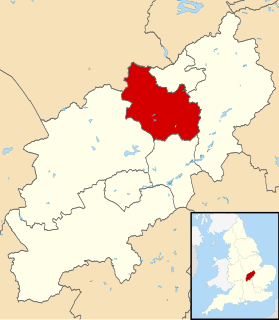
Northamptonshire is a county in the East Midlands of England. In 2015, it had a population of 723,000. The county is administered by two unitary authorities: North Northamptonshire and West Northamptonshire. It is known as "The Rose of the Shires".

Fair Haven is a borough in Monmouth County, in the U.S. state of New Jersey, and part of the New York Metropolitan Area. Fair Haven is located on the Rumson peninsula along the Navesink River and is bordered by Red Bank and Little Silver to the west. As of the 2010 United States Census, the borough's population was 6,121, reflecting an increase of 184 (+3.1%) from the 5,937 counted in the 2000 Census, which had in turn increased by 667 (+12.7%) from the 5,270 counted in the 1990 Census.

Northampton is a borough in Northampton County, Pennsylvania. Its population was 10,395 as of the 2020 census. Northampton is located 7.8 miles (12.6 km) north of Allentown, 66.7 miles (107.3 km) northwest of Philadelphia, and 93.8 miles (151.0 km) west of New York City.

Corby is a town in North Northamptonshire, England, located 23 miles (37 km) north-east of Northampton. From 1974 to 2021, the town served as the administrative headquarters of the Borough of Corby. At the 2011 Census, the built-up area had a population of 56,810, while the borough, which was abolished in 2021, had a population of 75,571 in 2021.
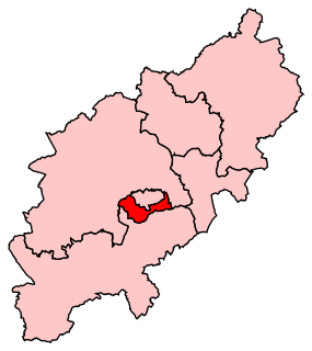
The Borough of Kettering was from 1974 to 2021 a local government district and borough in Northamptonshire, England. It was named after its main town Kettering where the council was based. It bordered onto the district of Harborough in the neighbouring county of Leicestershire, the borough of Corby, the district of East Northamptonshire, the district of Daventry and the borough of Wellingborough.

The Northampton Balloon Festival was an annual hot air balloon festival held in Northampton, England.

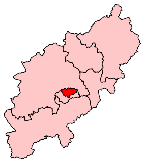
The Borough of Wellingborough was from 1974 to 2021 a non-metropolitan district and borough in Northamptonshire, England. It was named after Wellingborough, its main town, but also included surrounding rural areas.
Sixfields is an area of Northampton, Northamptonshire, England about 1 mile (1.6 km) west of the town centre along the A4500 St James Road and Weedon Road towards M1 junction 16 about 2 miles (3.2 km) further west. It is close to the Duston, Upton and St James areas of the town. Located next to The River Nene and The Grand Union Canal, Sixfields is often called "The Starcity of Northamptonshire".
Northampton South is a constituency represented in the House of Commons of the UK Parliament since 2017 by Andrew Lewer, a Conservative.
Northampton North is a constituency represented in the House of Commons of the UK Parliament since 2010 by Michael Ellis, a Conservative.

Northampton Old Northamptonian Chenecks F.C. are a football club based in Northampton, England. They play in the Spartan South Midlands League Division One.

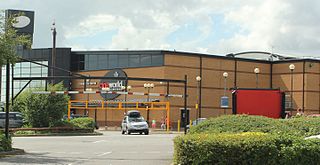
Sixfields Stadium is a 7,798-capacity all-seater sports stadium in the Sixfields area on the west side of Northampton, England. It has been the home ground of Northampton Town Football Club following their move from the County Ground in October 1994. It was also rented by Coventry City between July 2013 and August 2014. Aside from being a sports venue, Sixfields also houses conference facilities.

St Crispin's School, founded in 1953, is a coeducational comprehensive secondary school and sixth form located in Wokingham, Berkshire, England. There were 1,164 students at the school in 2017, of whom 234 were in the Sixth form. The school is on the London Road, just outside Wokingham town centre.
Radlands was a skate park situated in Northampton, England. It was constructed in 1992 by the Ince family in a former warehouse and was the first ever indoor skate park built in Britain. The 10,000 sq ft (930 m2) park was, before its closure, one of the largest in Britain. The owners claim that over 250,000 people used the park in its 12 years of operation. It was closed on 10 October 2004 due to being unprofitable, despite a campaign by local councillors on Northampton Borough Council to save it.
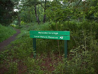
Lings Wood is a 20.1 hectare Local Nature Reserve in eastern Northampton. It is owned by Northampton Borough Council and managed by the Wildlife Trust for Bedfordshire, Cambridgeshire and Northamptonshire.

The Northampton Carnival has had strong traditions in the town from the 1960s through the Midsummer Meadow times in the 1980s, to its short break in the late 1990s, until its revival in 2005.

Victoria Park is a public green space in St. James End, Northampton, England, south of Spencer Bridge Road. The park has open grass areas and lines and belts of trees. A stream, a tributary of the River Nene flows from north to south through the park on the east side next to the railway line. A small stream, Dallington Brook, also flows through the park from the north-west joining the Nene tributary. The park has an area of about 6.5 hectares.

Kingsthorpe Meadow is a 14.4 hectare Local Nature Reserve in Northampton. It is owned by Northampton Borough Council and managed by the Wildlife Trust for Bedfordshire, Cambridgeshire and Northamptonshire.

Bradlaugh Fields is a 60-hectare (150-acre) open space in Northampton. The site is a former golf course. In 1987 it was proposed to build housing on the site, but after a campaign by local residents it was acquired by Northampton Borough Council and opened as a wildlife park in 1998. It was named after Charles Bradlaugh, a leading nineteenth century radical and atheist who was MP for Northampton. Three fields with a total area of 17.5 hectares are managed by the Wildlife Trust for Bedfordshire, Cambridgeshire and Northamptonshire as a nature reserve also called Bradlaugh Fields. Hills and Holes is at the southern end and two adjoining meadows, Scrub Field and Quarry Field, are at the northern end. Hills and Holes is an 8.3 hectare Local Nature Reserve (LNR) and Scrub Field is a 5.1-hectare (13-acre) LNR.

