St. James End, Northampton

Last updated

St. James' End
St James' Parish Church, Northampton, England.jpg
St James' Parish Church, St James' Road
Northamptonshire UK location map (2021).svg
Red pog.svg
St. James' End
Location within Northamptonshire
Population5,465 (Ward. 2011)
OS grid reference SP745605
  London 68 miles
Civil parish
Unitary authority
Ceremonial county
Region
Country England
Sovereign state United Kingdom
Post town NORTHAMPTON
Postcode district NN5
Dialling code 01604
Police Northamptonshire
Fire Northamptonshire
Ambulance East Midlands
UK Parliament
  • Northampton South
List of places
UK
England
Northamptonshire
52°14′17″N0°54′40″W / 52.238°N 0.911°W / 52.238; -0.911

St. James End, also known as St. James, colloquially as Jimmy's End, and historically as St James's End, is a district west of the town centre in Northampton, in the West Northamptonshire district, in the ceremonial county of Northamptonshire, England. The area developed from the mid to late 19th century particularly with the expansion of the shoe manufacturing and engineering industries, and also the extension of the railway from London in June 1882. [1]

Contents

History

Northampton Abbey

The area is named after St James' Abbey which was founded in the town 1104–05 by William Peverel as an Augustinian monastery dedicated to St James and which was built in the area of the modern development. [2] The abbey was located in the Abbots Way area, off the south side of Weedon Road in the town (see map).

The former Express Lift factory, which included the lift-testing tower, was redeveloped for housing in 1999–2000. The site was known to occupy part of the precinct of the abbey. Excavations were carried out to determine the location and remains of any parts of the abbey.

The abbey and a cemetery were located. The main buildings were preserved beneath the new housing development. The cemetery of c.300 burials was excavated during winter 2000–2001. The bones were analysed to determine the health and burial practices in the late medieval population of Northampton. [3]

294 burials were uncovered in well ordered rows, with many wooden coffins, graves lined with old ceramic roof-tiles, stone-lined graves and a single stone coffin suggesting the occupants of relatively high status. [4]

Use of the cemetery later was less orderly. Burials were in simple, shallow graves with just a shroud. On the south side was a stone-built building with two mortuary chapels. One had a stone-lined tomb, and a fragment of life-sized sculptured leg, with chain mail and a stirrup strap from a broken effigy. This may have happened at the dissolution of the abbey in 1538.

A highly decorated grave slab and the remains of two skeletons had been unearthed in 1970. [4]

Analysis of the burials shows a large number of elderly people many having suffered from trauma such as leg fractures, fused and/or deformed leg joints and advanced spine degeneration. Many of these may have died in the abbey infirmary and further analysis is being undertaken. [4]

First World War

On 19 October 1917 at 10.45 pm German Zeppelins dropped bombs near Burghley Park then passed over Northampton dropping nine incendiary bombs over Kingsthorpe, Dallington and Far Cotton. Another fell on the roof of 46 Parkwood Street on St. James probably aiming for the Station.

The house was occupied by Mr. Henry Gammons, a railway bricklayer, who was away at the time. His wife, Mrs. Eliza Gammons, and twin daughters Gladys and Lily, aged 13, were in bed. The bomb passed through the house to the bedroom, killing the mother instantly and set fire to the room. Both mother and daughters were killed. [5]

Governance

The St James area today forms part of the civil parish of Northampton in West Northamptonshire.

When significant development in the area began in the nineteenth century, it was outside the borough boundaries of Northampton, in the neighbouring parishes of Dallington and Duston. An ecclesiastical parish called "St James, Dallington" was created in 1872 covering parts of the two older parishes. [6] The neighbouring local government district of Hardingstone (which had been created in 1871 covering the Far Cotton area) was enlarged in 1874 to also include the new ecclesiastical parish of St James. [7]

Local government districts were reconstituted as urban districts under the Local Government Act 1894, which also said that parishes could no longer straddle district boundaries. The parts of the civil parishes of Dallington and Duston within the urban district of Hardingstone therefore became separate parishes called "Dallington St James" and "Duston St James". The urban district was divided into two urban districts called Far Cotton and St James in 1896, with the St James Urban District comprising the two civil parishes of Dallington St James and Duston St James. [8] The St James Urban District was short-lived; it was abolished four years later in 1900 and absorbed into the county borough of Northampton. The two civil parishes continued to exist until 1913, but as urban parishes they never had parish councils, always being directly governed by the urban district or borough councils above them. [9]

Location map United Kingdom Northampton Central.png
Red pog.svg
Northampton Abbey (site)
Red pog.svg
Austin Friars
Red pog.svg
Blackfriars (prob. site)
Red pog.svg
Friars of the Sack (prob. site)
Red pog.svg
Greyfriars
Red pog.svg
St Andrews Priory
Red pog.svg
Whitefriars
Locations of monastic houses in Northampton

Notable buildings

St James today is most notable for the presence of the National Lift Tower in Weedon Road, formerly the Express Lift Tower and nicknamed the 'Northampton Lighthouse'. The building is a lift-testing tower built by the Express Lift Company which closed in 1990. [10] The building was officially opened by Queen Elizabeth II on 12 November 1982.

The Parish Church of St James in St James' Road was built in 1868–71 by R. Wheeler of Tonbridge, Kent, with additional work in 1900 and the tower in 1920. The brick is exposed inside and enriched with black bricks. [11]

The Doddridge Centre in St James Road was built in 1895 as the Doddridge Memorial Chapel in memory of Philip Doddridge (1702–1751), an English Nonconformist. It provides facilities and support to community and voluntary groups with 30 groups based in the building and another 40 using it as a meeting point for a variety of activities.

The chapel where Doddridge served from 1729–51 is in Doddridge Street on the east side of the river. It dates from 1695 and is now a United Reformed Church. The interior has galleries, box pews and a memorial to Doddridge. [11]

St James is home to the Northampton Saints Rugby Football Club at Franklin's Gardens stadium on the south-west side of lower Weedon Road. The club was established in 1880 under the original title of Northampton St James by Rev Samuel Wathen Wigg, a clergyman and curate of St James' Church. The Sixfields Stadium used by Northampton Town Football Club (known as "The Cobblers") at the top end of Weedon road in the area known as Sixfields currently playing in League Division Two. The Sixfields area also has a large Sainsbury's supermarket, Boots, M&S Simply Food, Wickes, McDonald's, several restaurants, a multi-screen cinema, and several other retail outlets.

The First Northampton bus service operated out of the former Northampton Transport depot on St James's Road but withdrew services on 14 September 2013. The depot remained in operation until 22 October 2013 to service the First Northampton operated Luton Airport Parkway railway stationLuton Airport service. It was then transferred to First Essex's Chelmsford depot. [12]

This left the large depot empty. It had been opened in 1904 as the main depot for electric trams and then in the 1920s for motorbuses. Between then and 1939 it was extended considerably, but in 2013 the last service bus left and the depot was made redundant. [13] In 2014 the site was acquired for expansion by Church's Shoes which has a factory next door. [14] [15] As of November 2022 the depot site remains unused and enclosed by Church's-branded hoarding.

Industry

Former works

The Express Lift factory closed in 1990 having been a major employer (see notable buildings). Mettoy had a large site, originally used as a boot factory, at the corner of Spencer Bridge Road and Harlestone Road, NN5 7AE, now occupied by Aldi and Iceland supermarkets. [16]

Current establishments

On St James Road between Sharman Road and Spencer Street is the factory of Church's the up-market footwear manufacturer founded in 1873 by Thomas Church. [17] The company is now owned by Prada. As at November 2022 plans to expand the factory into a part of the redundant bus depot next door remain unrealised. ( The depot site remains enclosed by Church's branded hoarding but untouched since 2014 ). The front entrance to the building has images of a Native American (see gallery).

This reflects the previous ownership by the company Padmore and Barnes; they produced footwear using a moccasin construction, and a Native American was their emblem; they produced some 6,000 pairs of moccasins in the first half of the 20th century. A statue stood at the top of the front of the building but was removed when the works closed. [18]

The large and thriving St James Industrial Estate along St James Mill Road near West Bridge is host to a large number of business and industrial establishments including the headquarters of Cosworth Engineering.

There are three public houses in St James: The Thomas Á Becket and the Foundrymans Arms in St James Road and The Sevens in Weedon Road. There is also a working men's club in Weedon Road. A fourth pub, The Castle, in St James Park Road, was converted to rented flats and a shop - marking the end of the building's use as a public house. More recently, Jimmy's Sports Bar opened on the Harlestone Road which includes a rooftop bar. [19]

Traffic issues

Both St James Road and Spencer Bridge Road feed into Weedon Road and are the main exits to the M1 motorway at junction 16. All these roads are busy 24/7 with heavy traffic, fumes and noise from vehicles. A recent report for Northampton Borough Council states: "Existing conditions within the study area show poor air quality, with concentrations of nitrogen dioxide exceeding the annual mean objective along Weedon Road and St James’ Road near to the development site. An AQMA (Air quality management area) has been declared for this area" . [20]

1998 floods

The part of St James in St James Road and the lower parts of Harlestone Road and Weedon Road are low lying and in the flood plain of the River Nene and its tributaries. In April 1998, many residents of both St James had to leave their homes and seek temporary accommodation elsewhere, after part of the area, along with Far Cotton and Cotton End, suffered flooding, when the River Nene broke its banks after torrential rain. Flooding occurred on Good Friday, 10 April 1998. Since then river banks have been raised and flood mitigation lakes created west of the town (see gallery). [21] [22]

Area maps and views

2014 map

There is no exact de-lineation of the St James area – the red outline on the modern map shown below gives the area generally regarded as St James. This differs from official designations of Borough Council Wards and County Council Divisions which often include additional areas used to even up the numbers of voters. The northern area comprises what are known as the 'Scottish streets' after their street names. On the west side, off Weedon Road, is the Lift Tower estate and several side roads up the hill to Sixfields.

In the south is the large and thriving St James Industrial Estate along St James Mill Road. Part of the St James area extends east of the railway into St James retail park.

The eastern part of St James lies just west of a tributary of the River Nene and the railway station and was the first part of the area to be developed for housing and industrial use in the mid and late 19th century as can be seen from the 1899 map. This area extends to Spencer Bridge Road in the north beyond which is the area of the town known as Spencer, after the Spencer family of Althorp, about 5 miles north, however the area includes the houses nearest to Harlestone Road including St James Church of England Primary School. This is the only school in the St James area and has nearly 500 pupils aged 3 to 11. [23] [24] The school was rated 'good' at the last OFSTED inspection. [25]

Part of the area south-west of St James Road appear on the 1899 map such as Abbey Street, Almad Street, Lincoln Road and Spencer Street. Other areas further up Weedon Road have terraced houses on the 1899 map but have been cleared for three blocks of council flats close to Franklin's Gardens stadium.

1899 map

The eastern part of St James was the first area to be developed for housing and industrial use in the mid and late 19th century as this map shows. There are three shoe factories shown, a tannery, saw mills and a cycle works. The railway arrived from London, Euston in 1881 on a loop line from the main line north of the village of Roade, although a connection to Market Harborough and further north was in place earlier.

The large goods area at the station reflects the main method of goods transit at the time. What is now Victoria Park is shown on the map as a recreation ground. The park was opened in 1898 on land donated by Earl Spencer of Althorp. At that time it was half the present size. Further land was acquired from the Earl in 1910 and 1911. As of August 2021 it has a children's play area, a changing rooms building used by visiting football teams, static outdoor exercise equipment and a multipurpose enclosed sports pitch ( remodelled from previous tennis courts ). The former bowling green was removed c.2000.

See also

Related Research Articles

<span class="mw-page-title-main">Northampton</span> Town in Northamptonshire, England

Northampton is a town and civil parish in Northamptonshire, England. It is the county town of Northamptonshire and the administrative centre of the unitary authority of West Northamptonshire. The town is situated on the River Nene, 60 miles (97 km) north-west of London and 50 miles (80 km) south-east of Birmingham. Northampton is one of the largest towns in England; the population of its overall urban area was recorded as 249,093 in the 2021 census.

<span class="mw-page-title-main">Market Harborough</span> Town in Leicestershire, England

Market Harborough is a market town in the Harborough district of Leicestershire, England, close to the border with Northamptonshire. The population was 24,779 at the 2021 census. It is the administrative headquarters of the Harborough district.

<span class="mw-page-title-main">Daventry District</span> Former local government district in England

Daventry District was a local government district in western Northamptonshire, England, from 1974 to 2021. The district was named after its main town of Daventry, where the council was based.

<span class="mw-page-title-main">Sixfields</span> Human settlement in England

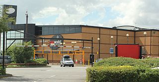
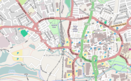
Sixfields is an area of Northampton, Northamptonshire, England about 1 mile (1.6 km) west of the town centre along the A4500 St James Road and Weedon Road towards M1 junction 16 about 2 miles (3.2 km) further west. It is close to the Duston, Upton and St James areas of the town. Located next to The River Nene and The Grand Union Canal, Sixfields is often called "The Starcity of Northamptonshire".

<span class="mw-page-title-main">Weedon Bec</span> Human settlement in England

Weedon Bec, usually just Weedon, is a village and parish in West Northamptonshire, England. It is close to the source of the River Nene. The population of the civil parish at the 2011 census was 2,706.

<span class="mw-page-title-main">Kingsthorpe</span> Suburb in Northampton, England

Kingsthorpe is a suburb and civil parish of Northampton, England. It is situated to the north of Northampton town centre and is served by the A508 and A5199 roads which join at Kingsthorpe's centre. The 2011 Census recorded the population of the district council ward as 4,477.

<span class="mw-page-title-main">Duston</span> Human settlement in England

Duston is a suburb of Northampton and a civil parish in West Northamptonshire, England.

<span class="mw-page-title-main">Northampton South (UK Parliament constituency)</span> Parliamentary constituency in the United Kingdom

Northampton South is a constituency represented in the House of Commons of the UK Parliament since 2017 by Andrew Lewer, a Conservative.

<span class="mw-page-title-main">Dallington, Northamptonshire</span> Suburb of Northampton in Northamptonshire, England

Dallington is an area and former civil parish about 1.5 miles (2.4 km) northwest of the centre of Northampton, now in the parish of Northampton, in the West Northamptonshire district, in the ceremonial county of Northamptonshire, England. Dallington was formerly a separate village. At the 2011 census the population was listed in the Spencer ward of Northampton Council.

<span class="mw-page-title-main">Upton, Northamptonshire</span> Human settlement in England

Upton is a civil parish north-east of Kislingbury and south-west of Dallington, in Northamptonshire, England about 3.5 miles (6 km) west of Northampton town centre along the A4500 road. Formerly a scattered hamlet, it is now part of the town. The area west of Northampton is now a major area of expansion of the town and named Upton after the parish.

<span class="mw-page-title-main">Hardingstone</span> Human settlement in England

Hardingstone is a village in Northamptonshire, England. It is on the southern edge of Northampton, and now forms a suburb of the town. It is about 1 mile (2 km) from the town centre. The Newport Pagnell road separates the village from the nearby village of Wootton, which has also been absorbed into the urban area.

<span class="mw-page-title-main">East Hunsbury</span> Human settlement in England

East Hunsbury is a large residential area in the south of Northampton, England, situated around 3 miles (5 km) from the town centre and 1 mile (2 km) from junction 15 of the M1 motorway. For administrative purposes it is part of the unitary authority of West Northamptonshire. It is part of the Hunsbury conglomeration, which also includes West Hunsbury on the west side of Towcester Road. Shelfleys is the original name for the area of Northampton currently referred to as West Hunsbury. The name of West Hunsbury still appears on maps for the district as Shelfleys. Merefield is the corresponding name for East Hunsbury, together with the name "Blacky More" for the eastern part of East Hunsbury. All three names are still on local direction signs in Northampton, although older references are no longer in use by the local people living there. The areas developed in the 1980s and 1990s as part of the expansion of Northampton. The Northampton loop of the West Coast Main Line railway running between Northampton and London Euston runs under East and West Hunsbury via the Hunsbury Hill Tunnel emerging near Hill Farm Rise which follows the original course of Towcester Road prior to the 1980s. Ventilation shafts are visible in the housing estate in Yeoman Meadow. East Hunsbury was awarded ‘Best Large Village’ in 2019 by NorthantsAcre.

The Northampton Abbey of St James was founded in Northampton in 1104–05 by William Peverel, as a house of Augustinian canons, and was dedicated to St James. William Peverel endowed it with some forty acres in nearby Duston, the church of Duston, and the parish's mill.

<span class="mw-page-title-main">West Northamptonshire</span> District in England

West Northamptonshire is a unitary authority area covering part of the ceremonial county of Northamptonshire, England, created in 2021. By far the largest settlement in West Northamptonshire is the county town of Northampton. Its other significant towns are Daventry, Brackley and Towcester; the rest of the area is predominantly agricultural villages though it has many lakes and small woodlands and is passed through by the West Coast Main Line and the M1 and M40 motorways. The district includes the site of the Roman town of Bannaventa, and the grade I listed Althorp House and its estate.

<span class="mw-page-title-main">Far Cotton</span> Human settlement in England

Far Cotton is a village and neighbourhood of Northampton and former civil parish, now in the parish of Far Cotton and Delapre, in the West Northamptonshire district of Northamptonshire, England.

<span class="mw-page-title-main">Northampton Street Tramways</span> Horse powered tramway company

The Northampton Street Tramways Company operated a horse powered tramway service in Northampton between 1881 and 1901.

<span class="mw-page-title-main">Victoria Park, Northampton</span>

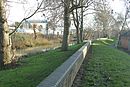
Victoria Park is a public green space in St. James End, Northampton, England, south of Spencer Bridge Road. The park has open grass areas and lines and belts of trees. A stream, a tributary of the River Nene flows from north to south through the park on the east side next to the railway line. A small stream, Dallington Brook, also flows through the park from the north-west joining the Nene tributary. The park has an area of about 6.5 hectares.

References

  1. Brown, Cynthia (7 December 1990). Northampton 1835–1985. Phillimore & Co Ltd. ISBN   0-8503-3767-4.
  2. "A History of the County of Northampton: Volume 3, 1930". Phillimore & Co Ltd. Retrieved 12 January 2013.
  3. "The Medieval Abbey of St. James (Part 1) 1999 – 2001 excavations". Northants Archaeology. Archived from the original on 12 January 2014. Retrieved 12 January 2014.
  4. 1 2 3 "The Medieval Abbey of St. James (Part 2) 2001–2002 excavations". Northants Archaeology. Retrieved 12 January 2014.
  5. Full story: Far Cotton Historical Society, accessed 2014_01_21
  6. "No. 23886". The London Gazette . 13 August 1872. p. 3593.
  7. "Local Government Board's Provisional Orders Confirmation (No. 4) Act 1874". legislation.gov.uk. The National Archives. Retrieved 7 November 2023.
  8. Annual Report of the Local Government Board. London: Her Majesty's Stationery Office. 1896. p. 368. Retrieved 7 November 2023.
  9. "St James Urban District". A Vision of Britain through Time. GB Historical GIS / University of Portsmouth. Retrieved 7 November 2023.
  10. Freshwater, R. (15 August 2010). "Roots of the Company – The rise and fall of the GEC empire". britishtelephones.com. Retrieved 3 July 2013.
  11. 1 2 Pevsner, Nikolaus; Cherry, Bridget (revision) (1961). The Buildings of England – Northamptonshire. London and New Haven: Yale University Press. pp. 306–7. ISBN   978-0-300-09632-3.
  12. "Office of the Traffic Commissioner Notices and Proceedings September 2013 Office of the Traffic Commissioner 4 September 2013 Accessed 2014_01_17" (PDF).
  13. Fatbusbloke (20 September 2013). "Public Transport Experience: Last Notes on First Northampton (Possibly)". Public Transport Experience. Retrieved 9 June 2023.
  14. SJRA (23 December 2014). "San Jacinto River Authority" . Retrieved 9 June 2023.
  15. "Public Transport Experience: First's Long, Lingering Northampton Death?". 16 May 2013.
  16. Ordnance Survey 1:2,500 map of Northampton South 1901
  17. Church's history section, Accessed 2014_01_18
  18. "Padmore and Barnes - Graces Guide". www.gracesguide.co.uk.
  19. "Take a look around a cool new rooftop bar complete with extensive views of Northampton". www.northamptonchron.co.uk. 15 September 2020. Retrieved 17 January 2022.
  20. Air Quality Consultants report on Franklin Gardens expansion, October 2013, Accessed 1014_01_17
  21. "The big mop-up: One year on". BBC News. 18 October 1999. Retrieved 16 February 2014.
  22. "1998 Easter Floods Remembered". BBC Northamptonshire. Retrieved 18 February 2009.
  23. "County Council website for St James School, accessed 2014_01_17".
  24. "Department for Education performance data for St James School, Northampton, Accessed 2014_01_17".
  25. "Find an inspection report and registered childcare". reports.ofsted.gov.uk. 17 September 2023.