St Martin-in-Meneage

Last updated

St Martin-in-Meneage
Parish church of St Martin-in-Meneage - geograph.org.uk - 369421.jpg
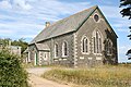
St Martin in Meneage parish church
Cornwall UK mainland location map.svg
Red pog.svg
St Martin-in-Meneage
Location within Cornwall
OS grid reference SW734240
Civil parish
  • St Martin-in-Meneage
Unitary authority
Ceremonial county
Region
Country England
Sovereign state United Kingdom
Post town HELSTON
Postcode district TR12
Dialling code 01326
Police Devon and Cornwall
Fire Cornwall
Ambulance South Western
UK Parliament
List of places
UK
England
Cornwall
50°04′19″N5°09′58″W / 50.072°N 5.166°W / 50.072; -5.166 Coordinates: 50°04′19″N5°09′58″W / 50.072°N 5.166°W / 50.072; -5.166

St Martin-in-Meneage (Cornish : Dydemin) [1] is a civil parish and village in the Meneage district of the Lizard Peninsula in Cornwall, England, United Kingdom.

Contents

The village is five miles (8 km) south-southeast of Helston. [2] The population at the 2011 census was 377 [3]

The church is dedicated to St Martin of Tours and is a chapelry of Mawgan in Meneage (right of sepulture was granted in 1385). The ancient estates of Barry Mylor and Mathiana adjoin the church and the two names indicate that in early times there were chapels of two Breton saints here, of St Melor at Merther Mylor (Barry Mylor) and St Anou at Merther Anou (the modern forms having been variously corrupted). [4]

St Martin-in-Meneage lies within the Cornwall Area of Outstanding Natural Beauty (AONB).

Related Research Articles

St Keverne Human settlement in England

St Keverne is a civil parish and village on The Lizard in Cornwall, England, United Kingdom.

Creed, Cornwall Human settlement in England

Creed is a hamlet in mid Cornwall, England, United Kingdom. It is roughly midway between Truro and St Austell, about two miles (3 km) east of Probus.

Flushing, Cornwall Human settlement in England

Flushing is a coastal village in the civil parish of Mylor, west Cornwall, UK. It is 3 miles (5 km) east of Penryn and 10 miles (16 km) south of Truro. It faces Falmouth across the Penryn River, an arm of the Carrick Roads. The village is known for its yearly Regatta week in July.

Diocese of Truro Church of England diocese

The Diocese of Truro is a Church of England diocese in the Province of Canterbury which covers Cornwall, the Isles of Scilly and a small part of Devon. The bishop's seat is at Truro Cathedral.

Hundreds of Cornwall administrative divisions into which Cornwall was divided between c. 925 and 1894

The hundreds of Cornwall were administrative divisions (hundreds) into which Cornwall, the present day administrative county of England, in the United Kingdom, was divided between c. 925 and 1894, when they were replaced with local government districts

Mylor Bridge Human settlement in England

Mylor Bridge(Cornish: Ponsnowyth) is a village in Cornwall, England, United Kingdom. It is in Mylor civil parish at the head of Mylor Creek, about five miles north of Falmouth.

Quethiock Human settlement in England

Quethiock is a village and civil parish in Cornwall, England, United Kingdom, roughly five miles east of Liskeard. According to the 2001 census the parish had a population of 429, increasing to 443 at the 2011 census. The ancient parish church of St Hugh is one of the most notable in Cornwall. The placename derives from the Old Cornish cuidoc meaning wooded place. In 1871 the population was 661 and the area 4,351 acres (17.61 km2).

Manaccan civil parish and village on the Lizard peninsula in south Cornwall, England

Manaccan is a civil parish and village on the Lizard peninsula in south Cornwall, England, United Kingdom. The village is about five miles (8 km) south-southwest of Falmouth.

St Michael Caerhays village in Cornwall, England

St Michael Caerhays is a civil parish and village in Cornwall, England, United Kingdom. The village is about seven miles (11 km) south-southwest of St Austell. The population as of the 2011 census was 96

Roche, Cornwall village in the United Kingdom

Roche is a civil parish and village in mid-Cornwall, United Kingdom. The village gets its name from a granite outcrop east of the village. Roche is the Norman-French word for Rock. On the southern flank of the village is the 20-metre (66-foot) high Roche Rock, a large granite outcrop. The parish population at the 2011 census including Belowda, Bilberry, Carbis, Coldvreath and Criggan is 3,381, and the ward population at the same census was 3,867.

St Michael Penkevil human settlement in United Kingdom

St Michael Penkivel, sometimes spelt St Michael Penkevil, is a civil parish and village in Cornwall, England, United Kingdom. It is in the valley of the River Fal about three miles (5 km) southeast of Truro. The population at the 2011 census was 257. St Michael Penkivel lies within the Cornwall Area of Outstanding Natural Beauty (AONB). Merther and Lamorran are within the parish.

Mylor, Cornwall civil parish in Cornwall, England, United Kingdom

Mylor is a civil parish in Cornwall, England, United Kingdom. It is situated approximately five miles north of Falmouth.

Probus, Cornwall village in United Kingdom

Probus is a civil parish and village in Cornwall, England, in the United Kingdom. It is famous for having the tallest church tower in Cornwall. The tower is 129 feet (39 m) high, and richly decorated with carvings. The place name originates from the church's dedication to Saint Probus. The parish population at the 2011 census was 2,299, whereas the ward population taken at the same census was 3,953.

St Anthony-in-Meneage human settlement in United Kingdom

St Anthony-in-Meneage is a coastal civil parish and village in Cornwall, England, United Kingdom. The parish is in the Meneage district of the Lizard peninsula. In the 2001 census the parish had a population of 171, decreasing to 168 at the 2011 census.

Wendron Human settlement in England

Wendron is a village and civil parish in Cornwall, England, United Kingdom, 3 miles (5 km) to the north of Helston. The parish population at the 2011 census was 2,743. The electoral ward of Wendron had a 2011 population of 4,936.

Tresillian village in Cornwall, United Kingdom

Tresillian is a small village in mid Cornwall, England, United Kingdom. It is three miles (5 km) east of Truro on the A390 road. Tresillian means "a place of eels" in the Cornish language, according to a 19th-century writer. However, modern toponymists agree that the name in fact translates as "farm/settlement of a man called Sulyen".

Merther Human settlement in England

Merther is a small hamlet 2 miles (3 km) east of Truro in Cornwall, England. It lies on the eastern side of the Tresillian River in the civil parish of St Michael Penkevil. It was formerly the churchtown of the small parish of Merther, and also the site of a manor house and medieval chapel dedicated to St Cohan. The former parish church is now in ruins.

Mylor Churchtown village in United Kingdom

Mylor Churchtown is a coastal village in Cornwall, England. It is the church town of the ecclesiastical parish of Mylor and is situated at the mouth of Mylor Creek, approximately three miles north of Falmouth.

Meneage

The Meneage is a district in west Cornwall, United Kingdom. The nearest large towns are Falmouth and Penryn.

References

  1. Place-names in the Standard Written Form (SWF)  : List of place-names agreed by the MAGA Signage Panel. Cornish Language Partnership.
  2. Ordnance Survey: Landranger map sheet 204 Truro & Falmouth ISBN   978-0-319-23149-4
  3. "Parish population 2011" . Retrieved 14 February 2015.
  4. Henderson, Charles (1925) "Parochial history of Cornwall", in: Cornish Church Guide. Truro: Blackford; p. 155