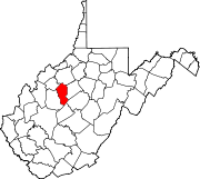
Stinson, West Virginia

Last updated
Stinson, West Virginia
Unincorporated community
USA West Virginia location map.svg
Red pog.svg
Stinson
Location within the state of West Virginia
Usa edcp location map.svg
Red pog.svg
Stinson
Stinson (the US)
Coordinates: 38°39′23″N81°4′28″W / 38.65639°N 81.07444°W / 38.65639; -81.07444 Coordinates: 38°39′23″N81°4′28″W / 38.65639°N 81.07444°W / 38.65639; -81.07444
Country United States
State West Virginia
County Calhoun
Time zone Eastern (EST) (UTC-5)
  Summer (DST) EDT (UTC-4)

Stinson is an unincorporated community in Calhoun County, West Virginia, United States. It lies along West Virginia Route 16 and the West Fork Little Kanawha River, to the south of the town of Grantsville, the county seat of Calhoun County. [1] [2] Its elevation is 823 feet (251 m). [3] At some point, Stinson possessed a post office, which has since been closed. [4]

Unincorporated area Region of land not governed by own local government

In law, an unincorporated area is a region of land that is not governed by a local municipal corporation; similarly an unincorporated community is a settlement that is not governed by its own local municipal corporation, but rather is administered as part of larger administrative divisions, such as a township, parish, borough, county, city, canton, state, province or country. Occasionally, municipalities dissolve or disincorporate, which may happen if they become fiscally insolvent, and services become the responsibility of a higher administration. Widespread unincorporated communities and areas are a distinguishing feature of the United States and Canada. In most other countries of the world, there are either no unincorporated areas at all, or these are very rare; typically remote, outlying, sparsely populated or uninhabited areas.

Calhoun County, West Virginia county in West Virginia, United States

Calhoun County is a county in the U.S. state of West Virginia. As of the 2010 census, the population was 7,627. Its county seat is Grantsville. The county was founded in 1856 and named for South Carolina politician John C. Calhoun.

West Virginia State of the United States of America

West Virginia is a state located in the Appalachian region in the Southern United States and is also considered to be a part of the Middle Atlantic States. It is bordered by Pennsylvania to the north, Maryland to the east and northeast, Virginia to the southeast, Kentucky to the southwest, and Ohio to the northwest. West Virginia is the 41st largest state by area, and is ranked 38th in population. The capital and largest city is Charleston.

The Stinson-Mud Fork area was known as a wild and wooly area in the early 1900s and was the subject of a song by Appalachian fiddler Blind Ed Haley, "Don't Go Up Stinson After Dark."

In 2009, Stinson became the location of West Virginia's first Dedicated Appleseed Range (DAR). A DAR is a location where year round Revolutionary War Veterans Association (RWVA) events are held to instruct citizens in rifle marksmanship and American Heritage. This venue brings an influx of people from other parts of WV and surrounding states, which injects some welcome revenue and gives exposure to this under served area.

Project Appleseed is a rifle marksmanship clinic that focuses on teaching traditional rifle marksmanship from standing, sitting/kneeling, and prone positions over a two-day weekend shooting clinic for what is termed an "Appleseed". It is one of the major activities of The Revolutionary War Veterans Association (RWVA), a 501(c)(3) non-profit organization that teaches and promotes traditional rifle marksmanship, while also teaching American heritage and history with the intent of encouraging people to become active civically. Project Appleseed is apolitical, a legal requirement of 501(c)(3) organizations.

Related Research Articles

Elkfork, Kentucky Unincorporated community in Kentucky, United States

Elkfork is an unincorporated community in Morgan County, Kentucky, United States. It lies along Route 172, northeast of the city of West Liberty, the county seat of Morgan County. Its elevation reaches up to 856 feet (261 m). Although the area is unincorporated, Elkfork contains a post office, with the ZIP code of 41421.

Stacy Fork, Kentucky Unincorporated community in Kentucky, United States

Stacy Fork is an unincorporated community in Morgan County, Kentucky, United States. It lies along Route 191 south of the city of West Liberty, the county seat of Morgan County. Its elevation is 823 feet (251 m).

Orma, West Virginia Unincorporated community in West Virginia, United States

Orma is an unincorporated community in Calhoun County, West Virginia, United States. It lies along West Virginia Route 16 and the West Fork Little Kanawha River, to the south of the town of Grantsville, the county seat of Calhoun County. Its elevation is 738 feet. Although it is unincorporated, it has a post office, with the ZIP code of 25268.

Chloe, West Virginia Unincorporated community in West Virginia, United States

Chloe is an unincorporated community in Calhoun County, West Virginia, United States. It lies along West Virginia Route 16 and the West Fork Little Kanawha River, to the south of the towns of Grantsville and Arnoldsburg. Its elevation is 794 feet (242 m). Although it is unincorporated, it has a post office, with the ZIP code of 25235.

Arnoldsburg, West Virginia Unincorporated community in West Virginia, United States

Arnoldsburg is an unincorporated community in Calhoun County, West Virginia, United States. It lies along U.S. Route 33 at the point where West Virginia Route 16 heads southward; it is several miles south of the county seat of Grantsville. Its elevation is 738 feet. The West Fork Little Kanawha River flows through the community. Although it is unincorporated, it has a post office, with the ZIP code of 25234.

Millstone, West Virginia Unincorporated community in West Virginia, United States

Millstone is an unincorporated community in Calhoun County, West Virginia, United States. It lies along U.S. Route 33 at the point where West Virginia Route 16 heads northward, to the south of the town of Grantsville, the county seat of Calhoun County. Its elevation is 810 feet. Although it is unincorporated, it has a post office, with the ZIP code of 25261.

Sand Ridge, West Virginia Unincorporated community in West Virginia, United States

Sand Ridge is an unincorporated community in Calhoun County, West Virginia, United States. It lies along U.S. Route 33 to the south of the town of Grantsville, the county seat of Calhoun County. Its elevation is 1,168 feet.

Mount Zion, West Virginia Unincorporated community in West Virginia, United States

Mount Zion is an unincorporated community in Calhoun County, West Virginia, United States. It lies along West Virginia Route 16 to the south of the town of Grantsville, the county seat of Calhoun County. Its elevation is 1,132 feet. Mount Zion's ZIP code is 26151.

Bigbend, West Virginia Unincorporated community in West Virginia, United States

Big Bend is an unincorporated community in Calhoun County, West Virginia, United States. It lies along West Virginia Route 5 northwest of the town of Grantsville, the county seat of Calhoun County, along the Little Kanawha River. Its elevation is 682 feet. Although it is unincorporated, it has a post office, with the ZIP code of 26136.

Big Springs, West Virginia Unincorporated community in West Virginia, United States

Big Springs is an unincorporated community in Calhoun County, West Virginia, United States. It lies along West Virginia Route 16 to the north of the town of Grantsville, the county seat of Calhoun County. Its elevation is 771 feet. Although it is unincorporated, it has a post office, with the ZIP code of 26137.

Annamoriah, West Virginia Unincorporated community in West Virginia, United States

Annamoriah is an unincorporated community in Calhoun County, West Virginia, United States. It lies along West Virginia Route 5 to the west of the town of Grantsville, the county seat of Calhoun County. Its elevation is 994 feet. Their post office closed in 1988.

Five Forks, Calhoun County, West Virginia Unincorporated community in West Virginia, United States

Five Forks is an unincorporated community in Calhoun County, West Virginia, United States. It lies along West Virginia Route 16 to the north of the town of Grantsville, the county seat of Calhoun County. Its elevation is 1,106 feet (337 m). The Five Forks Post Office is closed.

Hix, Summers County, West Virginia Unincorporated community in West Virginia, United States

Hix is an unincorporated community in Summers County, West Virginia, United States. It lies to the northeast of the city of Hinton, the county seat of Summers County. Its elevation is 2,618 feet. At some point, Hix possessed a post office, which closed on December 6, 1975.

Indian Mills, West Virginia Unincorporated community in West Virginia, United States

Indian Mills is an unincorporated community in Summers County, West Virginia, United States. It lies to the southeast of the city of Hinton, the county seat of Summers County. Its elevation is 1,545 feet.

Nimitz, West Virginia Unincorporated community in West Virginia, United States

Nimitz is an unincorporated community in Summers County, West Virginia, United States. It lies along West Virginia Route 3 to the west of the city of Hinton, the county seat of Summers County. Its elevation is 2,523 feet. Although it is unincorporated, it has a post office, with the ZIP code of 25978.

Pipestem, West Virginia Unincorporated community in West Virginia, United States

Pipestem is an unincorporated community in Summers County, West Virginia, United States. It lies along West Virginia Route 20 to the south-southwest of the city of Hinton, the county seat of Summers County. Its elevation is 2,382 feet. Although it is unincorporated, it has a post office, with the ZIP code of 25979.

Center Point, West Virginia Unincorporated community in West Virginia, United States

Center Point is an unincorporated community in northeastern Doddridge County, West Virginia, USA. It lies along Route 23 northeast of the town of West Union, the county seat of Doddridge County. Its elevation is 791 feet (241 m).

New Milton, West Virginia Unincorporated community in West Virginia, United States

New Milton is an unincorporated community in central Doddridge County, West Virginia, United States. The community is located along Meathouse Fork, southeast of the town of West Union, the county seat of Doddridge County. Its elevation is 833 feet (254 m). Although it is unincorporated, it has a post office, with the ZIP code of 26411.

Yawkey, West Virginia Unincorporated community in West Virginia, United States

Yawkey is an unincorporated community in eastern Lincoln County, West Virginia, United States. It lies at the intersection of West Virginia Routes 3 and 214, east of the town of Hamlin, the county seat of Lincoln County. Its elevation is 738 feet (225 m). Although it is unincorporated, it had a post office, with the ZIP code of 25573.

Peewee, West Virginia Unincorporated community in West Virginia, United States

Peewee is an unincorporated community in southwestern Wirt County, West Virginia, United States. It lies along local roads southwest of the town of Elizabeth, the county seat of Wirt County. Its elevation is 679 feet (207 m). Right Reedy Creek is formed at Peewee by the confluence of Enoch Fork and Fulls Fork.

References

  1. Rand McNally. The Road Atlas '04. Chicago: Rand McNally, 2004, p. 112.
  2. West Virginia Atlas & Gazetteer. Yarmouth, Me.: DeLorme. 1997. p. 44. ISBN   0-89933-246-3.
  3. U.S. Geological Survey Geographic Names Information System: Stinson, West Virginia, Geographic Names Information System, 1980-06-12. Accessed 2008-01-17.
  4. U.S. Geological Survey Geographic Names Information System: Stinson, West Virginia, Geographic Names Information System, 1996-05-09. Accessed 2008-01-17.