Stotts City, Missouri

Last updated
Stotts City, Missouri
Lawrence County Missouri Incorporated and Unincorporated areas Stotts City Highlighted.svg
Location of Stotts City, Missouri
Coordinates: 37°6′11″N93°56′48″W / 37.10306°N 93.94667°W / 37.10306; -93.94667 Coordinates: 37°6′11″N93°56′48″W / 37.10306°N 93.94667°W / 37.10306; -93.94667
Country United States
State Missouri
County Lawrence
Area
[1]
  Total0.51 sq mi (1.33 km2)
  Land0.51 sq mi (1.33 km2)
  Water0.00 sq mi (0.00 km2)
Elevation
1,145 ft (349 m)
Population
 (2020)
  Total167
  Density326.17/sq mi (126.00/km2)
Time zone UTC-6 (Central (CST))
  Summer (DST) UTC-5 (CDT)
ZIP code
65756
Area code 417
FIPS code 29-70990 [2]
GNIS feature ID0727160 [3]

Stotts City is a city in Lawrence County, Missouri, United States. The population was 220 at the 2010 census. It was estimated to be 217 by the City of Stotts City as of July 1, 2019. [4]

Contents

Geography

Stotts City is located at 37°6′11″N93°56′48″W / 37.10306°N 93.94667°W / 37.10306; -93.94667 (37.102983, -93.946662). [5]

According to the United States Census Bureau, the city has a total area of 0.51 square miles (1.32 km2), all land. [6]

Demographics

Historical population
CensusPop.Note
1900 902
1910 548−39.2%
1920 354−35.4%
1930 271−23.4%
1940 268−1.1%
1950 2856.3%
1960 221−22.5%
1970 203−8.1%
1980 23214.3%
1990 2351.3%
2000 2506.4%
2010 220−12.0%
2020 167−24.1%
U.S. Decennial Census [7]

2010 census

As of the census [8] of 2010, there were 220 people, 84 households, and 53 families residing in the city. The population density was 431.4 inhabitants per square mile (166.6/km2). There were 108 housing units at an average density of 211.8 per square mile (81.8/km2). The racial makeup of the city was 93.2% White, 0.9% African American, 0.5% Native American, 3.2% from other races, and 2.3% from two or more races. Hispanic or Latino of any race were 5.9% of the population.

There were 84 households, of which 28.6% had children under the age of 18 living with them, 45.2% were married couples living together, 11.9% had a female householder with no husband present, 6.0% had a male householder with no wife present, and 36.9% were non-families. 31.0% of all households were made up of individuals, and 14.3% had someone living alone who was 65 years of age or older. The average household size was 2.62 and the average family size was 3.09.

The median age in the city was 42 years. 20.9% of residents were under the age of 18; 6.9% were between the ages of 18 and 24; 27.3% were from 25 to 44; 27.8% were from 45 to 64; and 17.3% were 65 years of age or older. The gender makeup of the city was 50.0% male and 50.0% female.

2000 census

As of the census [2] of 2000, there were 250 people, 98 households, and 63 families residing in the city. The population density was 486.2 inhabitants per square mile (187.7/km2). There were 117 housing units at an average density of 227.5 per square mile (87.8/km2). The racial makeup of the city was 87.60% White, 1.20% African American, 4.00% Native American, 3.60% from other races, and 3.60% from two or more races. Hispanic or Latino of any race were 9.20% of the population.

There were 98 households, out of which 30.6% had children under the age of 18 living with them, 49.0% were married couples living together, 11.2% had a female householder with no husband present, and 34.7% were non-families. 30.6% of all households were made up of individuals, and 11.2% had someone living alone who was 65 years of age or older. The average household size was 2.55 and the average family size was 3.11.

In the city the population was spread out, with 26.8% under the age of 18, 9.2% from 18 to 24, 28.8% from 25 to 44, 19.6% from 45 to 64, and 15.6% who were 65 years of age or older. The median age was 35 years. For every 100 females, there were 110.1 males. For every 100 females age 18 and over, there were 101.1 males.

The median income for a household in the city was $18,958, and the median income for a family was $28,125. Males had a median income of $17,031 versus $16,250 for females. The per capita income for the city was $8,942. About 26.2% of families and 24.6% of the population were below the poverty line, including 24.1% of those under the age of eighteen and 36.6% of those 65 or over.

History

The town was settled in the early 1870s and was originally known as 'Pax', then later as 'Belle Plaine'. It was incorporated in 1896 and renamed in memory of its founder, Capt. Greene Casey Stotts, who died in 1876. Stotts held a command in the US Army during the Civil War, distinguished himself while in charge of the 76th Enrolled Missouri Militia, Co. D, the 7th E Missouri Militia, Co. C, and the 15th Missouri Cavalry, Company C. He later represented Lawrence County in the Missouri state legislature.

Stotts discovered galena and hemimorphite deposits west of the town and began to develop the lead mining industry that later fueled Stotts City's booming growth. He founded the Stotts City Mining Company in July, 1873.[ citation needed ] The Lawrence County Land & Mining Company, formed in 1888, handled the product of the Stotts City Mining District.

In its heyday, Stotts City was home to several banks, a large hardware store, The Farmers Exchange Co-op, a cooperative enterprise of the local grain and dairy farmers, a school and numerous churches, and even had a volunteer brass band and a newspaper, The Stotts City Sunbeam, [9] published from 1901 until the end of 1907. The population of Stotts City peaked at 902 in 1900. By 1910, the population dropped to 548. [10]

Soon after the end of World War I, the demand for lead ore from the Lawrence County Land & Mining Company subsided, as groundwater issues made it increasing difficult and expensive to mine. With a depressed agricultural industry in the 1920s, the 1929 stock market crash and Great Depression, Stotts City suffered a further reduction in population, a loss of retail businesses and closure of its one remaining bank. By December 1942, the mines and the Stotts City Mining Company were closed.[ citation needed ]

The construction of U.S. Route 66 north of Stotts City and later, Interstate 44 south of town, provided an opportunity for increased commerce. Establishments such as "Hattie's Hamburger Heaven" became regional favorites.

In the 1930s and 1940s, the Farmers Exchange Co-op provided feed grain and seed for most of western Lawrence County. Until the mid-1970s, Stotts City bore a remarkable resemblance to the classic movie 'western town', with its wide main street and rows of buildings with false fronts. The old bandstand, at the corner of Mt. Vernon and Center streets, still stands; a relic of the late 19th century, as does the old native-stone schoolhouse and First Baptist Church, both built in 1898. Several descendants of the earliest residents of Stotts City still live in the area.

Industry

Stotts City is surrounded by cattle and dairy farms, and the area is known for world-class thoroughbred horses. In 1981, Jim and Sallie Stearns established the Stearnsy Bears, with manufacturing in Stotts City. These heirloom-quality teddy bears have been featured on Hallmark and American Greetings cards, and are shipped worldwide.

Notable people

Capt. Greene Casey Stotts USA, 1821-1876—American military officer and Missouri state legislator

PFC Charles Denver Barger, USA, 1892-1936—American soldier and hero of World War I, Medal of Honor recipient

Rev. Dr. H. Dale Jackson, 1930-2003—Baptist minister, denominational leader and ethicist

Related Research Articles

<span class="mw-page-title-main">Lawrence County, Missouri</span> County in Missouri, United States

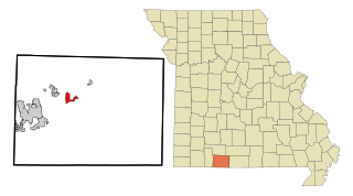
Lawrence County is located in the southwest portion of the U.S. state of Missouri, in the area of the Ozarks. As of the 2010 census, the population was 38,634. Its county seat is Mount Vernon. The county was organized in 1845 and named for James Lawrence, a naval officer from the War of 1812 known for his battle cry, "Don't give up the ship!"

<span class="mw-page-title-main">Coleraine, Minnesota</span> City in Minnesota, United States

Coleraine is a city in Itasca County, Minnesota, United States. The population was 1,970 at the 2010 census. The community was named after Thomas F. Cole, President of the Oliver Iron Mining Company.

<span class="mw-page-title-main">Lincoln, Missouri</span> City in Benton County, Missouri, United States

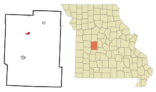
Lincoln is a city in Benton County, Missouri, United States. The population was 1,190 at the 2010 census.

<span class="mw-page-title-main">Fremont Hills, Missouri</span> City in Missouri, United States

Fremont Hills is a city in Christian County, Missouri, United States. The population was 1,049 at the 2020 census. It is part of the Springfield, Missouri Metropolitan Statistical Area.

<span class="mw-page-title-main">Highlandville, Missouri</span> City in Missouri, United States

Highlandville is a city in Christian County, Missouri, United States. The population was 963 at the 2020 census. It is part of the Springfield, Missouri Metropolitan Statistical Area.

<span class="mw-page-title-main">Oronogo, Missouri</span> City in Missouri, United States

Oronogo is a city in Jasper County, Missouri, United States. The population was 2,558 at the 2020 census. It is part of the Joplin, Missouri Metropolitan Statistical Area.

<span class="mw-page-title-main">Aurora, Missouri</span> City in Missouri, United States

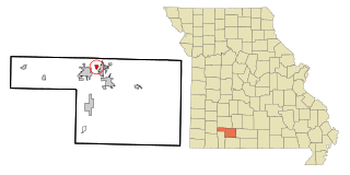
Aurora is a city in Lawrence County, Missouri, United States. As of the 2020 census, the population of the city was 7,432.

<span class="mw-page-title-main">Freistatt, Missouri</span> Village in Missouri, United States

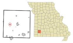
Freistatt is a village in Lawrence County, Missouri, United States. The population was 163 at the 2010 census.

<span class="mw-page-title-main">Halltown, Missouri</span> Village in Missouri, United States

Halltown is a village in Lawrence County, Missouri, United States. The population was 173 at the 2010 census.

<span class="mw-page-title-main">Hoberg, Missouri</span> Village in Missouri, United States

Hoberg is a village in Lawrence County, Missouri, United States. The population was 48 at the 2020 census.

<span class="mw-page-title-main">Miller, Missouri</span> City in Missouri, United States

Miller is a town in Lawrence County, Missouri, United States. As of the 2010 census, the city population was 699.

<span class="mw-page-title-main">Verona, Missouri</span> City in Missouri, United States

Verona is a city in Lawrence County, Missouri, United States. The population was 619 at the 2010 census, later estimated to be 826 as of July 1, 2020.

<span class="mw-page-title-main">Wheeling, Missouri</span> City in Missouri, United States

Wheeling is a city in eastern Livingston County, Missouri, United States. The population was 220 at the 2020 census.

<span class="mw-page-title-main">Wentworth, Missouri</span> Village in Missouri, United States

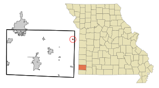
Wentworth is a village in northeastern Newton County, Missouri, United States. The population was 151 at the 2010 census. It is part of the Joplin, Missouri Metropolitan Statistical Area.

<span class="mw-page-title-main">Leadington, Missouri</span> City in Missouri, United States

Leadington is a city in St. Francois County, Missouri, United States. The population was 422 at the 2010 census.

<span class="mw-page-title-main">Mount Vernon, Missouri</span> City in Missouri, United States

Mount Vernon is a city in and the county seat of Lawrence County, Missouri, United States. The population was 4,575 as of the 2010 census. It was estimated to be 4,960 by the City of Mount Vernon on July 1, 2020.

<span class="mw-page-title-main">Reeds Spring, Missouri</span> City in Missouri, United States

Reeds Spring is a city in Stone County, Missouri, United States. The population was 1,136 at the 2020 census. It is part of the Branson, Missouri Micropolitan Statistical Area.

<span class="mw-page-title-main">Forsyth, Missouri</span> City in Missouri, United States

Forsyth is a city in Taney County, Missouri, United States. The population was 2,730 at the 2020 census. It is the county seat of Taney County. The town is part of the Branson, Missouri Micropolitan Statistical Area. Forsyth is located on Lake Taneycomo on U.S. Route 160.

<span class="mw-page-title-main">Central City, South Dakota</span> City in South Dakota, United States

Central City is a city in Lawrence County, South Dakota, United States. The population was 93 at the 2020 census.

<span class="mw-page-title-main">Abbotsford, Wisconsin</span> City in Wisconsin, United States

Abbotsford is a city in Clark (mostly) and Marathon counties in the U.S. state of Wisconsin. The population was 2,275 at the 2020 census. Of this, 1,665 were in Clark County, and 610 were in Marathon County. Abbotsford is nicknamed "Wisconsin's First City" due to its alphabetical place on a list of Wisconsin cities.

References

  1. "ArcGIS REST Services Directory". United States Census Bureau. Retrieved August 28, 2022.
  2. 1 2 "U.S. Census website". United States Census Bureau . Retrieved 2008-01-31.
  3. "US Board on Geographic Names". United States Geological Survey. 2007-10-25. Retrieved 2008-01-31.
  4. Bureau, US Census. "Population and Housing Unit Estimates Tables". The United States Census Bureau. Retrieved 2020-07-22.
  5. "US Gazetteer files: 2010, 2000, and 1990". United States Census Bureau. 2011-02-12. Retrieved 2011-04-23.
  6. "US Gazetteer files 2010". United States Census Bureau. Archived from the original on 2012-01-25. Retrieved 2012-07-08.
  7. "Census of Population and Housing". Census.gov. Retrieved June 4, 2015.
  8. "U.S. Census website". United States Census Bureau . Retrieved 2012-07-08.
  9. Missouri Newspapers on Microfilm - State Historical Society of Missouri , retrieved July 11, 2010
  10. Bill K. Stotts, Family History Report for Captain Green C. Stotts , retrieved July 11, 2010