Sylvan Grove, Kansas

Last updated

Sylvan Grove, Kansas
Sylvan Grove, Kansas UP depot from SW 1.JPG
Former rail depot (2014)
Lincoln County Kansas Incorporated and Unincorporated areas Sylvan Grove Highlighted.svg
Location within Lincoln County and Kansas
Map of Lincoln Co, Ks, USA.png
Coordinates: 39°0′46″N98°23′33″W / 39.01278°N 98.39250°W / 39.01278; -98.39250 [1]
Country United States
State Kansas
County Lincoln
Founded1877
Incorporated 1899
Named for sylvan groves
Area
[2]
  Total0.39 sq mi (1.00 km2)
  Land0.39 sq mi (1.00 km2)
  Water0.00 sq mi (0.00 km2)
Elevation
[1]
1,444 ft (440 m)
Population
 (2020) [3]
  Total291
  Density750/sq mi (290/km2)
Time zone UTC-6 (CST)
  Summer (DST) UTC-5 (CDT)
ZIP code
67481
Area code 785
FIPS code 20-69775
GNIS ID 472542 [1]

Sylvan Grove is a city in Lincoln County, Kansas, United States. [1] As of the 2020 census, the population of the city was 291. [3]

Contents

History

Sylvan Grove was founded in 1877, at the site where a mill had been built in 1875. [4] The city was named for twin sylvan groves near the original town site. [5]

The Evangelical Lutheran School (at 38 N. Indiana St) and the Sylvan Grove Union Pacific Depot (131 S. Main St) are listed on the National Register of Historic Places.

Geography

According to the United States Census Bureau, the city has a total area of 0.37 square miles (0.96 km2), all of it land. [6]

Climate

The climate in this area is characterized by hot, humid summers and generally mild to cool winters. According to the Köppen Climate Classification system, Sylvan Grove has a humid subtropical climate, abbreviated "Cfa" on climate maps. [7]

Demographics

Historical population
CensusPop.Note
1880 25
1900 319
1910 46445.5%
1920 450−3.0%
1930 53017.8%
1940 5401.9%
1950 506−6.3%
1960 400−20.9%
1970 4030.8%
1980 376−6.7%
1990 321−14.6%
2000 3240.9%
2010 279−13.9%
2020 2914.3%
U.S. Decennial Census

2010 census

As of the census [8] of 2010, there were 279 people, 138 households, and 88 families living in the city. The population density was 754.1 inhabitants per square mile (291.2/km2). There were 192 housing units at an average density of 518.9 per square mile (200.3/km2). The racial makeup of the city was 98.6% White, 0.7% Native American, and 0.7% from two or more races. Hispanic or Latino of any race were 1.1% of the population.

There were 138 households, of which 22.5% had children under the age of 18 living with them, 46.4% were married couples living together, 12.3% had a female householder with no husband present, 5.1% had a male householder with no wife present, and 36.2% were non-families. 35.5% of all households were made up of individuals, and 14.5% had someone living alone who was 65 years of age or older. The average household size was 2.02 and the average family size was 2.58.

The median age in the city was 46.9 years. 22.2% of residents were under the age of 18; 3.6% were between the ages of 18 and 24; 18.7% were from 25 to 44; 35.1% were from 45 to 64; and 20.4% were 65 years of age or older. The gender makeup of the city was 51.6% male and 48.4% female.

2000 census

As of the census [9] of 2000, there were 324 people, 157 households, and 88 families living in the city. The population density was 876.5 inhabitants per square mile (338.4/km2). There were 195 housing units at an average density of 527.6 per square mile (203.7/km2). The racial makeup of the city was 96.91% White, 1.85% Native American, 0.93% from other races, and 0.31% from two or more races. Hispanic or Latino of any race were 1.54% of the population.

There were 157 households, out of which 21.7% had children under the age of 18 living with them, 48.4% were married couples living together, 3.8% had a female householder with no husband present, and 43.9% were non-families. 40.8% of all households were made up of individuals, and 24.8% had someone living alone who was 65 years of age or older. The average household size was 2.06 and the average family size was 2.82.

In the city, the population was spread out, with 21.0% under the age of 18, 4.9% from 18 to 24, 23.1% from 25 to 44, 23.5% from 45 to 64, and 27.5% who were 65 years of age or older. The median age was 46 years. For every 100 females, there were 98.8 males. For every 100 females age 18 and over, there were 98.4 males.

The median income for a household in the city was $27,188, and the median income for a family was $36,375. Males had a median income of $20,962 versus $16,250 for females. The per capita income for the city was $14,684. About 13.5% of families and 17.6% of the population were below the poverty line, including 27.4% of those under age 18 and 6.3% of those age 65 or over.

Education

The community is served by Sylvan–Lucas USD 299 public school district.

School unification consolidated Sylvan Grove schools with Hunter and Vesper schools to form Sylvan Unified schools in 1966. In 2010, school unification combined Sylvan Unified with Lucas-Luray schools to form USD 299, Sylvan-Lucas Unified schools. Sylvan-Lucas Unified is located in Sylvan Grove.

The Sylvan Grove High School mascot was the Jayhawks. Sylvan Unified and Sylvan-Lucas Unified mascot has been the Mustangs since unification. [10]

Libraries

The Sylvan Grove Public Library was organized in the fall of 1925 by the Tuesday Club. The first library was housed in a central room above the Sylvan State Bank. In 1938, the city took over the library and it was moved to a southeast corner room of the bank. In 1949, a fund-raiser was held to purchase several hundred books. On December 1, 1956, the library was moved to its present location in City Hall.

See also

Related Research Articles

<span class="mw-page-title-main">Russell County, Kansas</span> County in Kansas, United States

Russell County is a county in the U.S. state of Kansas. Its county seat and largest city is Russell. As of the 2020 census, the population was 6,691. The county was named for Avra Russell. The city of Russell was the home of former U.S. Senate Majority leader and 1996 GOP presidential nominee Bob Dole for many years.

<span class="mw-page-title-main">Lincoln County, Kansas</span> County in Kansas, United States

Lincoln County is a county located in the U.S. state of Kansas. Its county seat and largest city is Lincoln Center. As of the 2020 census, the county population was 2,939. The county was named after Abraham Lincoln, the 16th president of the United States.

<span class="mw-page-title-main">Garnett, Kansas</span> City in Anderson County, Kansas

Garnett is a city in and the county seat of Anderson County, Kansas, United States. As of the 2020 census, the population of the city was 3,242.

<span class="mw-page-title-main">Coldwater, Kansas</span> City in Comanche County, Kansas

Coldwater is a city and county seat of Comanche County, Kansas, United States. As of the 2020 census, the population of the city was 687.

<span class="mw-page-title-main">Gove City, Kansas</span> City in Gove County, Kansas

Gove City, more commonly known as Gove, is a city in and the county seat of Gove County, Kansas, United States. As of the 2020 census, the population of the city was 80.

<span class="mw-page-title-main">Tribune, Kansas</span> City in Greeley County, Kansas

Tribune is a city in and the county seat of Greeley County, Kansas, United States. As of the 2020 census, the population of the city was 772.

<span class="mw-page-title-main">Zenda, Kansas</span> City in Kingman County, Kansas

Zenda is a city in Kingman County, Kansas, United States. As of the 2020 census, the population of the city was 72.

<span class="mw-page-title-main">Mound City, Kansas</span> City and County seat in Kansas, United States

Mound City is a city in and the county seat of Linn County, Kansas, United States. As of the 2020 census, the population of the city was 647.

<span class="mw-page-title-main">Fowler, Kansas</span> City in Meade County, Kansas

Fowler is a city in Meade County, Kansas, United States. As of the 2020 census, the population of the city was 534.

<span class="mw-page-title-main">Meade, Kansas</span> City in Meade County, Kansas

Meade is a city in and the county seat of Meade County, Kansas, United States. As of the 2020 census, the population of the city was 1,505.

<span class="mw-page-title-main">Glen Elder, Kansas</span> City in Mitchell County, Kansas

Glen Elder is a city in Mitchell County, Kansas, United States. As of the 2020 census, the population of the city was 362.

<span class="mw-page-title-main">Hunter, Kansas</span> City in Mitchell County, Kansas

Hunter is a city in Mitchell County, Kansas, United States. As of the 2020 census, the population of the city was 51.

<span class="mw-page-title-main">Council Grove, Kansas</span> City in Morris County, Kansas

Council Grove is a city and county seat in Morris County, Kansas, United States. As of the 2020 census, the population of the city was 2,140. It was named after an agreement between American settlers and the Osage Nation allowing settlers' wagon trains to pass westward through the area on the Santa Fe Trail. Pioneers gathered at a grove of trees so that wagons could band together for their trip west.

<span class="mw-page-title-main">Wilsey, Kansas</span> City in Morris County, Kansas

Wilsey is a city in Morris County, Kansas, United States. As of the 2020 census, the population of the city was 139.

<span class="mw-page-title-main">Utica, Kansas</span> City in Ness County, Kansas

Utica is a city in Ness County, Kansas, United States. As of the 2020 census, the population of the city was 99.

<span class="mw-page-title-main">Damar, Kansas</span> City in Rooks County, Kansas

Damar is a city in Rooks County, Kansas, United States. As of the 2020 census, the population of the city was 112.

<span class="mw-page-title-main">Lucas, Kansas</span> City in Russell County, Kansas

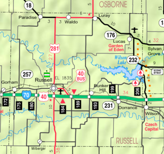
Lucas is a city in Russell County, Kansas, United States. As of the 2020 census, the population of the city was 332.

<span class="mw-page-title-main">Luray, Kansas</span> City in Kansas, United States

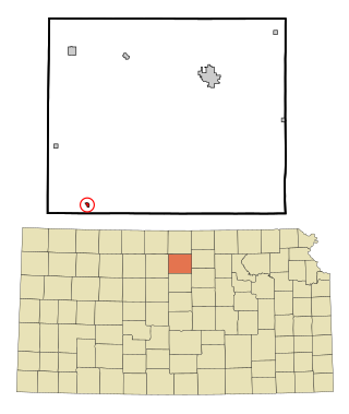
Luray is a city in Russell County, Kansas, United States. As of the 2020 census, the population of the city was 166.

<span class="mw-page-title-main">Benedict, Kansas</span> City in Wilson County, Kansas

Benedict is a city in Wilson County, Kansas, United States, along the Verdigris River. As of the 2020 census, the population of the city was 69.

<span class="mw-page-title-main">Sylvan Lake, Michigan</span> City in Michigan, United States

Sylvan Lake is a city in Oakland County in the U.S. state of Michigan. The population was 1,720 at the 2010 census. As a northern suburb of Metro Detroit, Sylvan Lake is about 20 miles (32 km) northwest of the city of Detroit. The city also shares a northeastern border with the city of Pontiac.

References

  1. 1 2 3 4 "Sylvan Grove, Kansas", Geographic Names Information System , United States Geological Survey, United States Department of the Interior
  2. "2019 U.S. Gazetteer Files". United States Census Bureau. Retrieved July 24, 2020.
  3. 1 2 "Profile of Sylvan Grove, Kansas in 2020". United States Census Bureau. Archived from the original on March 30, 2022. Retrieved March 30, 2022.
  4. Blackmar, Frank Wilson (1912). Kansas: A Cyclopedia of State History, Volume 2. Standard Publishing Company. pp.  794.
  5. Kansas State Historical Society (1916). Biennial Report of the Board of Directors of the Kansas State Historical Society. Kansas State Printing Plant. pp.  225.
  6. "US Gazetteer files 2010". United States Census Bureau. Archived from the original on January 25, 2012. Retrieved July 6, 2012.
  7. Climate Summary for Sylvan Grove, Kansas
  8. "U.S. Census website". United States Census Bureau . Retrieved July 6, 2012.
  9. "U.S. Census website". United States Census Bureau . Retrieved January 31, 2008.
  10. "Lebanon Overtime Win Over Sylvan", The Belleville Telescope, 7 December 1978, p.6.

Further reading