Thathri | |
---|---|
Town / Tehsil | |
Coordinates: 33°08′43″N75°47′28″E / 33.14528°N 75.79111°E | |
Country | India |
Union Territory | Jammu and Kashmir |
Division | Jammu |
Region | Chenab Valley |
District | Doda |
Founded by | Waaz Khan [1] |
Area | |
• Total | 1.50 km2 (0.58 sq mi) |
Elevation | 662 m (2,172 ft) |
Population (2011). [2] | |
• Total | 59,955 |
• Density | 40,000/km2 (100,000/sq mi) |
• Male | 31,627 |
• Female | 28,328 |
Demonym | Thathrian [3] |
Languages | |
• Official Language | Hindi-Urdu |
• Spoken | Bhadarwahi, Kashmiri, Gujari, Urdu |
Time zone | UTC+5:30 (IST) |
PIN | 182203 |
Vehicle registration | JK06 |
Sub-divisional magistrate (SDM) | Er. Masood Ahmed Bichoo (JKAS) [4] |
BDC Chairperson [5] | Vacant |
DDC Member | Sandeep Singh Manhas (BJP) [6] |
Website | www |
Thathri is a town and a notified area committee in Doda district in the Jammu division of the Indian union territory of Jammu and Kashmir. [7] [8]
Thathri valley is located in the foothills of the Himalayan mountains, about 85 km from Batote. Apart from having ample forests, the town contains many small streams flowing through its various parts. It is located on the banks of the Chenab River and the town area is spread over 1.50 sq. Km². [9]
The word Thathri is derived from the Kashmiri word "Thath" (ٹہاٹھ).
The word thathri is derived from 'thath', which locally means a heap of wood or timber collected on the bank of the river Chenab in earlier times. The activities of collection of wood and timber were performed by local people of ancient Thathri (now called Upper Thathri) and from other villages like Tipri, Badanoo, Barshalla, Jangalwar, and Phagsoo. The locals earned their living by working as labourers in the collection of wood in the form of huge heaps of wood and timber, which were later on transported to Jammu by different agencies, both government and private. So the name thathri has its origin from the word 'thath', which could still be narrated today from the records of forest departments and revenue departments. So far as the transportation of wood or timber through Chenab water to the last stop at the bank of the Chenab river at Thathri continued till the construction of the Dool Hasti power project dam. After that, this tradition was discontinued and wood and timber were directly transported through trucks and other vehicles from the source of timber in the present day district of Kishtwar to other parts of Jammu and Kashmir. [10]
In ancient times, it was filled with the paddy fields of nearby villagers. As more and more people built their houses in place of these fields and finally it became a village. Over time, the population increased by people coming and settling here from nearby villages and also from places as far as Tral, Baramulla in Kashmir and the people who now settled in Thathri made it a center of business. The reasons for Kashmiri population settling here in the past in 17th or 18th century is matter of ambiguity between historians. However Sumantra Bose says it was repression by feudal class that drew people to the district of Doda. [11] In 2011 the population census reported that Thathri contained at least 93 villages. Thathri was formerly a part of Tehsil Bhadarwah, until it separated as a new Tehsil in 1981. In 2011 Thathri was upgraded to a town. On 23 July 2014 it was upgraded to Subdivision, and is now divided into five Tehsils as Thathri, Phagsoo, Kahara , Chiralla and Bhela. The first municipal elections of Thathri town were held in October 2018.
On 22 July 2017, a flash flood affected Thathri, killing 6 people and washing away 6 homes. [12]
Thathri town, the headquarters of Thathri tehsil, is an underdeveloping town in Doda district of Jammu and Kashmir as of 2019. [13]
Thathri is a historical and commercially important town in the Thathri subdivision. It is located along the left bank of Chenab river and National Highway 244 passes through the town.[ citation needed ]
As of 2020, demand for district status in Thathri subdivision is increasing with number of arguments with the present district. [14] On 1 February 2023, Thathri suffered from land subsidence that resulted in 300 people being displaced and 23 homes being declared unsafe; eight days later, another landslide blocked the highway that passes through the town. [15] [16]
Thathri town is located in the foothills of the Lesser Himalayas, 34 km far from Doda city and 30 km from Kishtwar and Batote-Kishtwar National Highway 244 passes through the town.
Climate data for Thathri, Jammu and Kashmir, India | |||||||||||||
---|---|---|---|---|---|---|---|---|---|---|---|---|---|
Month | Jan | Feb | Mar | Apr | May | Jun | Jul | Aug | Sep | Oct | Nov | Dec | Year |
Mean daily maximum °C (°F) | 7.6 (45.7) | 10.7 (51.3) | 16.1 (61.0) | 21.4 (70.5) | 25.5 (77.9) | 29.3 (84.7) | 30.4 (86.7) | 29.8 (85.6) | 27.8 (82.0) | 22.9 (73.2) | 16.3 (61.3) | 9.9 (49.8) | 20.6 (69.1) |
Mean daily minimum °C (°F) | −1.9 (28.6) | 0.7 (33.3) | 4.1 (39.4) | 7.8 (46.0) | 11.1 (52.0) | 15.2 (59.4) | 18.5 (65.3) | 17.6 (63.7) | 12.9 (55.2) | 6.1 (43.0) | 1 (34) | −1.3 (29.7) | 7.7 (45.8) |
Average precipitation mm (inches) | 11.8 (0.46) | 28.5 (1.12) | 39.6 (1.56) | 23.3 (0.92) | 21 (0.8) | 27.3 (1.07) | 29.3 (1.15) | 29.8 (1.17) | 2.5 (0.10) | 10.7 (0.42) | 9.4 (0.37) | 13.4 (0.53) | 246.6 (9.67) |
Source: World Weather Online [17] |
The population of Thathri tehsil as of the 2011 census is 59,955, of which 31,627 are men and 28,328 are women, living in 6,797 households spread across a total of 93 villages and 33 panchayats. [2]
According to the 2011 census, the list of villages in Thathri along with their population is shown in the table below:
S. No. | Village | Administrative Division | Population |
---|---|---|---|
1 | Agrika | Thathri | 100. |
2 | Amrit Garh | Thathri | 266. |
3 | Bachhra | Thathri | 205. |
4 | Badanoo | Thathri | 450. |
5 | Bajah | Thathri | 567. |
6 | Banola | Thathri | 530. |
7 | Barshala | Thathri | 1,403. |
8 | Bathri | Thathri | 2,548 |
9 | Bhalara | Thathri | 708 |
10 | Bhatola | Kahara (Thathri) | 917 |
11 | Bhatoli | Thathri | 504 |
12 | Bhella | Thathri | 1,657 |
13 | Bolian | Thathri | 1,011 |
14 | Botagra | Thathri | 1,063 |
15 | Budhi | Thathri | 323 |
16 | Chagnu | Thathri | 269 |
17 | Chegsu | Thathri | 647 |
18 | Chira | Thathri | 542 |
19 | Chuteri | Thathri | 152 |
20 | Dadian | Thathri | 240 |
21 | DaronKerani | Thathri | 344 |
22 | Daronjamani | Thathri | 287 |
23 | Darori | Thathri | 101 |
24 | Dehra | Thathri | 200 |
25 | Deyoki | Thathri | 567 |
26 | Dhaliah | Thathri | 284 |
27 | DharYotha | Thathri | 2,096 |
28 | Dichhal | Thathri | 608 |
29 | Fagsu(Phagsoo) | Thathri | 2,709 |
30 | Galoo | Thathri | 399 |
31 | Ghaba | Thathri | 704 |
32 | Goela | Kahara (Thathri) | 803 |
33 | Gosti | Thathri | 1,017 |
34 | Grondra | Thathri | 261 |
35 | Gugara | Thathri | 731 |
36 | Gurekra | Thathri | 385 |
37 | Hagona | Thathri | 220 |
38 | Halaran | Kahara (Thathri) | 194 |
39 | Hanejo | Thathri | 196 |
40 | Herani | Thathri | 273 |
41 | HojaBola | Thathri | 673 |
42 | Indlu | Thathri | 411 |
43 | Indrala | Thathri | 868 |
44 | Jagota | Thathri | 406 |
45 | Jhandani | Thathri | 271 |
46 | Jangalwar | Thathri | 623 |
47 | Jasolah | Thathri | 122 |
48 | Jhajka | Thathri | 161 |
49 | Jia | Kahara (Thathri) | 190 |
50 | Joura Kalan | Thathri | 939 |
51 | Joura Khurd | Thathri | 1,108 |
52 | Kahi Trankal | Thathri | 1,049 |
53 | Kahla | Thathri | 333 |
54 | Kandote | Thathri | 990 |
55 | Kanso | Thathri | 475 |
56 | Kathawa | Thathri | 687 |
57 | Kawani | Thathri | 284 |
58 | Kemega | Thathri | 165 |
59 | Kencha | Kahara (Thathri) | 754 |
60 | Kolai | Thathri | 144 |
61 | KothiBala | Thathri | 173 |
62 | KothiPain | Thathri | 127 |
63 | Kundi | Thathri | 279 |
64 | Kuthiara | Thathri | 729 |
65 | Madren | Thathri | 75 |
66 | Mahri | Thathri | 272 |
67 | Malanu | Kahara (Thathri) | 553 |
68 | Malota | Thathri | 766 |
69 | Nagni | Thathri | 337 |
70 | Nai | Thathri | 230 |
71 | Nanadna | Thathri | 1,052 |
72 | Natwas | Thathri | 94 |
73 | Panthan | Thathri | 277 |
74 | Parnot | Thathri | 783 |
75 | Pemasa | Thathri | 562 |
76 | Piykal | Thathri | 448 |
77 | Puneja | Thathri | 1,167 |
78 | Ranote | Kahara (Thathri) | 371 |
79 | Renkha | Thathri | 350 |
80 | RukaliKalan | Thathri | 480 |
81 | RukaliKhurd | Thathri | 195 |
82 | Sahan | Thathri | 288 |
83 | Seesol | Thathri | 130 |
84 | Shahrote | Thathri | 598 |
85 | Shakla | Thathri | 81 |
86 | ShamDalain | Thathri | 328 |
87 | Sharni | Thathri | 357 |
88 | Shibnote | Thathri | 243 |
89 | Sichal | Kahara (Thathri) | 1,340 |
90 | Sunarthawa | Thathri | 938 |
91 | Suranga | Thathri | 502 |
92 | Tanta | Thathri | 2,324 |
93 | Thalela | Thathri | 2,014 |
94 | Thatri | Thathri | 4,938 |
95 | Garh | Thathri | 61 |
Thathri is the single town in Thathri subdivision of Doda district in the union territory of Jammu and Kashmir in India. It is the main town for the Thathri subdivision and also the Tehsil headquarters. Thathri village promoted as town in 2010. It is approximately 36 km from the district headquarters at Doda. Nearby villages include Zea Abad (0.05 km) Barshala (1.2 km),Sharote (2.5 km), Bagh(0.1 km). Drabshala (5.2 km), Tanta (10.5 km), Premnagar (12 km), and Bhatyass (15 km). The nearest towns are Doda (36 km), Bhaderwah (60 km), Bhalessa (Gandoh) (30.5 km) and Kishtwar (30.3 km).
Noon chai in kashmiri (commonly known in Hindi/Urdu as Namkeen Chai) or Pink Tea is a famous beverage of the people of Thathri. Villagers often start their workdays by sipping a cup of tea at their homes or hotels. Noon Chai (noon means salt, 'chai means tea) is eaten with traditional Kashmiri breads and pastries like lavasa, sheermaal, kandir chot, bakarkhani and kulcha. It is traditionally made from special tea leaves, milk, salt, and cooked in a samavar. A pinch of baking soda is added to help give it more of a pronounced pink color. A recent variant preparation of this tea also includes sugar but it is not traditionally consumed in Thathri. [18]
Doda district is an administrative district of the Jammu division of Indian-administered Jammu and Kashmir in the disputed Kashmir region.
Bhaderwah or Bhadarwah is a town, tehsil, and sub-district in the Doda district of Jammu Division of Jammu and Kashmir, India.
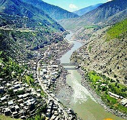
Ramban district is an administrative district in the Jammu division of Indian-administered Jammu and Kashmir in the disputed Kashmir region. It is located in a valley surrounded the Pir Panjal range. It was carved out as a separate district from erstwhile Doda district in 2007. It is located in the Jammu division. The district headquarters are at Ramban town, which is located midway between Jammu and Srinagar along the Chenab river in the Chenab valley on National Highway-44, approximately 151 km from Jammu and Srinagar.
Kishtwar district is an administrative district of the Jammu division of Indian-administered Jammu and Kashmir in the Jammu Division. As of 2011, it is the largest and the least populous district of Jammu and Kashmir.
The Chenab Valley is a river valley formed by the Chenab River. The term is also used collectively for Doda, Kishtwar and Ramban districts of Jammu Division in the Indian-administered Jammu and Kashmir. These districts were formerly part of a single district, called Doda.
Gandoh is a town and tehsil in the Doda district of Jammu division in the Indian union territory of Jammu and Kashmir. The village is located on Thathri-Gandoh National Highway.
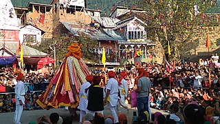
Jantroon Dhar or Jantroon Top is a location in the Doda district, in Jammu and Kashmir, India. It is a local hill station and a meadow in the Forest Block area, 15 kilometers away from Thathri. The place is surrounded by lush green meadows, snow in winters and covered with dense vegetation. Thousands of local tourists visit every year for spectating three days dangal-cum-wrestling match.
Ababeel (ابابیل), also known as Ababeel NGO, is a charitable trust that provides emergency assistance, disaster relief, food kits, and blood donations for the needy, poor, orphans, widows, and also in emergencies in the Chenab Valley's Doda, Kishtwar, Thathri, Bhaderwah, Gandoh, and also in the Jammu area. The organization assists people irrespective of caste and religion. It is registered with the Sub Registrar Court Doda.
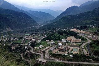
Zea Abad, is a village in Thathri sub division of Doda district. It is the part of panchayat Jangalwar located on the Batote-Kishtwar National Highway.
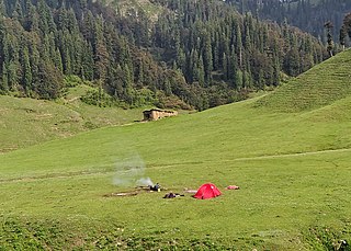
Jai Valley is an enchanting valley located 32 kilometres (20 mi) northeast of Bhaderwah town in Jammu and Kashmir, India. The Bhaderwah-Jai road, which passes through the corniferous deodar forests of Nakshri, Balote, Bhalara and Chinta Valley connects the valley with the Bhaderwah town. The valley has green meadows which act as the attraction for tourists in summers and the snow-covered landscape during winters. Jai valley has about 9 kilometres (5.6 mi) long meadows, bisected by a stream called Jai Nallah which merges with a tributary of river Chenab at Kahara in tehsil Thathri. It is also known by the names Jai Garh and Jai Top. The valley is also connected through a 37 kilometres (23 mi) long road with Gandoh. There is no Mobile Network in this valley.
Bhal Padri is a hill station situated above a group of small valleys covered with a dense forest located in the Changa, Bhalessa. area of Doda district. It borders Padri Pass, Bhaderwah at a distance of 4 kilometres (2.5 mi) northeast. Rivulets and streams flow through this valley.
Bhalessa is a geographical area within Doda district in the Jammu region of India-administered Kashmir. It consists of the Bunjwah and Bhalessa Valleys, and comprises the three Tehsils of Kahara, Chilly Pingal and Gandoh.
Kahara is a village and tehsil in the Doda district of the Jammu division of the Indian union territory of Jammu and Kashmir. It is situated between mountainous cliffs 13 kilometres (8.1 mi) from Thathri on the Thathri-Gandoh road.
Donadi is a village in Kahara tehsil of Doda district in the Indian union territory of Jammu and Kashmir. It is famous for a hydroelectric power project called Lower Kalnie Power Project Donadi.
Bunjwah is a region and tehsil located in the Kishtwar district of Jammu and Kashmir, India. It comprises nine panchayat and two nayabats; it became a tehsil in 2014.
Phagsoo is a village and tehsil in the Doda district of the Jammu division of Jammu and Kashmir, India. It was previously part of the Thathri tehsil. Also, the biggest village in Doda
Badanoo is a village in Thathri tehsil of Doda district in Jammu and Kashmir. It is located at least 36 kilometres from its district headquarters. This village is the part of Patwar Halqa Jangalwar.
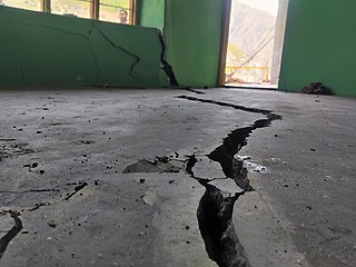
On 1 February 2023, a land subsidence event developed in the town of Thathri in the Doda district of Jammu and Kashmir, India, resulting in 23 structures being declared unsafe and approximately 300 people being displaced. The event has been described by geological experts as a multifactor landsliding. Buildings impacted include several houses, a mosque, a religious school for girls, and a cricket academy. As of 9 February 2023, a massive landsliding was reported at Nayi Basti which blocked National Highway 244 for hours. As of 23 March 2023, the incident spot is declared as "not habitable" by Geological Survey of India report.
The Kalnai River is a tributary of the Chenab River in the Bunjwah region bordering Kishtwar and Doda districts in Jammu and Kashmir. An under construction 48MW Lower Kalnai hydroelectric project is located at Donadi on this river.