
Udhampur (ˌʊd̪ʱəmpur) is a city and a municipal council in Udhampur district in the Indian union territory of Jammu and Kashmir. It is the headquarters of Udhampur District. Named after Raja Udham Singh, it serves as the district capital and the Northern Command headquarters of the Indian Army. A Forward Base Support Unit (FBSU) of the Indian Air Force is also stationed here. Udhampur is used by the Armed Forces as a transit point between Jammu and Srinagar when travelling by road on National Highway 1A, which has since been renamed as National Highway 44.
Bilaspur is a town and a municipal council in Bilaspur district in the Indian state of Himachal Pradesh.

Udhampur is an administrative district in the Jammu division of Indian-administered Jammu and Kashmir in the disputed Kashmir region. Covering an area of 4,550 square kilometres (1,760 sq mi) in the Himalayan mountains, the district has its headquarters in the town of Udhampur. The Northern Command headquarters of the Indian Army is located in the district.

Zangla is a village in Zanskar tehsil of Kargil district, in the Indian union territory of Ladakh. It is located 262 km (163 mi) southeast of Kargil city, the district headquarters, and 32 km (20 mi) northeast of Padum, the headquarters of Zanskar. An ancient ruined palace, known as Zangla Fort or Zangla Khar is located on a hilltop 1 km (0.62 mi) outside the village, believed to be 11th-century. The Buddhist nunnery in Zangla contains some impressive paintings.

Banihal is a town and a notified area committee, near Ramban town in Ramban district in the Indian union territory of Jammu and Kashmir. It is a rural and hilly area with Kamirwah being one of the most prominent hills. It is located about 35 km (22 mi) away from Qazigund of Anantnag district on NH 44. However, the distance between Banihal and Qazigund is only 18 km by train on the new railway line which is much shorter than the road. The most common language spoken in the region is Kashmiri; Urdu, Hindi, Gujjari, Pahari and English are other familiar languages.
Batote is a town and a notified area committee, near Ramban town in Ramban district of Indian union territory of Jammu and Kashmir on NH 44 just beyond Ramban, Patnitop while going towards Srinagar.

Kishtwar is a town, municipality and administrative headquarter of the Kishtwar district in the Indian-administered Jammu and Kashmir. The district was carved out of the Doda district in 2007. and is located in the Jammu division. The town of Kishtwar is situated at a distance of 209.5 km (130.2 mi) from the summer capital of Srinagar, and 211.5 km (131.4 mi) from the winter capital of Jammu. A large ground locally called as Chowgan ground is located in the heart of the town.
Kud is a town and a notified area committee in Udhampur district in the Indian union territory of Jammu and Kashmir. It is about 10 km from the popular tourist place Patnitop and is famous for a local sweet known as "Desi Ghee Patisa" another name of the sweet made up of milk products. Desi Ghee is a milk product and patisa is known as Papdi.

Qazigund, also known as Gateway Of Kashmir, is a town and in the union territory of Jammu and Kashmir, India. Qazigund is located at 33.59°N 75.16°E. It has an average elevation of 1670 m (5478 feet) above mean sea level.

Rajouri or Rajauri is a city in the Rajouri district in the Jammu division of the Indian union territory of Jammu and Kashmir. It is located about 155 kilometres (96 mi) from Srinagar and 150 km (93 mi) from Jammu city on the Poonch Highway.

Reasi is a town and a notified area committee and tehsil in Reasi district of the Indian union territory of Jammu and Kashmir. Situated on the bank of River Chenab, It is the headquarters of the Reasi district. In the eighth century, Reasi was a part of the Bhimgarh state established by Rajput king Bhim Dev Rasyal. The name Reasi is derived from the town's old name, "Rasyal".

Thanamandi is a town and a municipal committee in the Rajouri district in the Indian union territory of Jammu and Kashmir. Thanamandi lies on the Mughal Road between Rajouri and Bufliaz.

Patnitop is a hill station, located, between Ramban Town and Udhampur city in the Udhampur district of Jammu and Kashmir, India. It is in located on the Jammu-Srinagar National Highway, 112 km (70 mi) from Jammu, on the way from Udhampur to Srinagar. Situated on a plateau in the Shivalik belt of the Himalayas, Patnitop sits at an altitude of 2,024 m (6,640 ft). The river Chenab flows in close proximity to this location. Patnitop lies in District Udhampur of Jammu And Kashmir

Poonch, is a town and the administrative headquarters of the Poonch district, of the Indian-administered union territory of Jammu and Kashmir, which is part of the larger disputed territory of Kashmir. It is located near the Line of Control – the de facto border in the disputed region. Poonch shares a de facto border with the Poonch district of the Pakistan-administered, self-governing territory of Azad Kashmir.
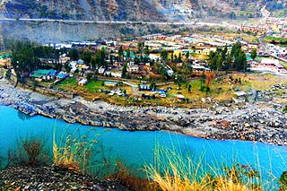
Ramban is a town in Ramban district of Jammu and Kashmir, India, which is the district headquarters of Ramban district. It lies on the banks of the Chenab river in Chenab Valley on the National Highway-1A at about 120 km from Jammu and about 130 km from Srinagar, making it almost the central point on the Jammu-Srinagar National Highway.

The Jammu–Srinagar National Highway is the northernmost segment of NH 44. It runs from Srinagar in the Kashmir Valley southward to the city of Jammu.
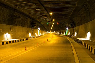
Chenani-Nashri Tunnel, Officially known as Dr. Syama Prasad Mookerjee Tunnel, is a road tunnel in Jammu and Kashmir, India. It is located in the Lower Himalayas, on National Highway 44. Construction started in 2011 and was completed by 2017.
Dudu is a village and municipality in Udhampur district of the Indian union territory of Jammu and Kashmir. The town is located 100 kilometres from the district headquarters Udhampur.
Pouni is a village and municipality in Reasi district of the Indian union territory of Jammu and Kashmir. The town is located 25 km from the district headquarters Reasi Town.
Chanderkot is a village panchayat located in Ramban district in the Indian state of Jammu-Kashmir.

