Reasi district

Last updated

Reasi district
District of Jammu and Kashmir administered by India
Mata vaishno devi hill.jpg
Mountains near Vaishno Devi Temple
Reasi district
Interactive map of Reasi district
Kashmir region. LOC 2003626427 - showing Jammu division administered by India in neon blue.jpg
Reasi district is in the Jammu division (shown with neon blue boundary) of Indian-administered Jammu and Kashmir (shaded in tan in the disputed Kashmir region [1]
Coordinates(Reasi): 33°05′N74°50′E / 33.09°N 74.84°E / 33.09; 74.84
Administering country India
Union territory Jammu and Kashmir
Division Jammu Division
Headquarters Reasi
Tehsils 1. Reasi, 2. Pouni, 3. Katra, 4. Bhamag, 5. Arnas, 6. Throo, 7. Chassana, 8. Thakrakote, 9. Mahore
Area
  Total1,719 km2 (664 sq mi)
Population
 (2011)
  Total314,667
  Density180/km2 (470/sq mi)
   Urban
8.6%
Demographics
   Literacy 58.15%
  Sex ratio890
Time zone UTC+05:30 (IST)
Vehicle registration JK-20
Website http://reasi.nic.in

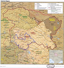
Reasi district is an administrative district in the Jammu division of Indian-administered Jammu and Kashmir in the disputed Kashmir region. [1] The Reasi district is bordered by Udhampur district and Ramban district in the east, Jammu district in the south, Rajouri district in the west and by Kulgam district on the north. The Reasi and Rajouri tehsils formed a joint district called the "Reasi district" at the time of the princely state's accession to India in 1947. As part of the reorganisation, the two tehsils were separated and Reasi was merged with the Udhampur district. It again became a separate district in 2006. [2]

Contents

Reasi is one of the oldest towns of the Jammu and Kashmir State. It was the seat of the erstwhile Bhimgarh State, said to have been established by Raja Bhim Dev sometime in the 8th century. It remained an independent principality till 1822, when Raja Gulab Singh the then Raja of Jammu hill region, under the Sikh empire, consolidated the small states.

Geography

Reasi is located at a distance of 64 km from Jammu and is bounded by Tehsil Gool-Gulabgarh in the north, Tehsil Sunderbani and Kalakote of District Rajouri in the west, Tehsil Udhampur in the east, Tehsils Jammu and Akhnoor of District Jammu on the south. Climatically a major part of this Sub-Division falls in the sub-tropical zone and the rest in temperate zone. Summers are generally warm and winters cold with snowfall on the high ridges.

Hindu sites

Major Hindu pilgrimage sites like Vaishno Devi, Shiv Khori, Baba Dhansar and Siyad Baba Waterfall are located in this district.

Access

Being far away from Jammu–Udhampur–Srinagar Highway 1-A and somewhat inaccessible due to the hilly area, economic progress in the mostly hilly region of Reasi has been rather slow. With the commissioning of Salal Hydroelectric Project at Dhyangarh near Reasi, the economic activity of the area has picked up considerably. Construction work for this project was started in 1970 by the National Hydro-Electric Power Corporation (NHPC) and the project was commissioned in 1987 when the first stage of 345 Megawatt power station was completed and balance/the second stage of the project with 345 MW was commissioned in 1995 making the total generation to 690 MW. Power from this project flows to the Northern Grid from where it is distributed to the states of J&K, Punjab, Haryana, Delhi, Himachal Pradesh, Rajasthan, Uttar Pradesh and Chandigarh.

The Jammu–Srinagar–Baramulla Railway line which is under construction passes through the Reasi district. The Railway line to Katra was inaugurated on 4 July 2014, by the Indian Prime Minister Narendra Modi at Shri Mata Vaishno Devi Katra railway station. From Katra, the Railway line traverses to Reasi-Banihal area with stations at Reasi, Salal A–Salal B, Surukot, Barala, Sangaldan, Kohli and Laole. The 1315 meters long railway bridge under construction over the river Chenab near Salal with a height of 383.10 meters from the river surface.

Demographics

Historical populations
YearPop.±%
1901 57,195    
1911 61,506+7.5%
1921 64,243+4.4%
1931 68,335+6.4%
1941 74,224+8.6%
1951 81,852+10.3%
1961 89,481+9.3%
1971 116,387+30.1%
1981 160,091+37.6%
1991 200,059+25.0%
2001 247,694+23.8%
2011 314,667+27.0%
source: [3]
† 1951 and 1991 populations are estimated
Religion in Reasi district (2011) [4]
ReligionPercent
Islam
49.66%
Hinduism
48.91%
Sikhism
0.99%
Other or not stated
0.44%

According to the 2011 census Reasi district has a population of 314,667, [5] [6] roughly equal to the nation of The Bahamas. [7] This gives it a ranking of 570th in India (out of a total of 640). [6] The district has a population density of 184 inhabitants per square kilometre (480/sq mi). [6] Its population growth rate over the decade 2001-2011 was 27.06%. [6] Reasi has a sex ratio of 890 females for every 1000 males [6] (which varies with religion), and a literacy rate of 59.42%. [6] The Scheduled Castes and Scheduled Tribes account for 12% and 28.1% of the population of the district. [8]

Reasi has a population which is nearly evenly split between Muslims and Hindus. Reasi's population stands at 314,667 (2011), of whom 49.67% are Muslims and 48.90% are Hindus.

Sex Ratio in Reasi District in 2011 Census. [4]
(no. females per 1,000 males)
Religion (and population)Sex Ratio
Muslim (pop 156,275)
915
Hindu (pop 153,898)
869
Sikh (pop 3,107)
924
Other (pop 1,387)
558
Total (pop 314,667)
890

Languages of Reasi district (2011) [9]

   Dogri (43.76%)
   Gojri (25.60%)
   Kashmiri (18.33%)
   Pahari (6.64%)
   Hindi (1.62%)
  Others (4.05%)
Reasi district: religion, gender ratio, and % urban of population, according to the 2011 Census. [4]
HinduMuslimChristianSikhBuddhistJainOtherNot statedTotal
Total153,898156,2751,2083,1071573154314,667
48.91%49.66%0.38%0.99%0.00%0.00%0.00%0.05%100.00%
Male82,35881,5987821,615114390166,461
Female71,54074,6774261,49243064148,206
Gender ratio (% female)46.5%47.8%35.3%48.0%26.7%42.9%0.0%41.6%47.1%
Sex ratio
(no. of females per 1,000 males)
869915545924890
Urban23,2453,0764611943001726,996
Rural130,653153,1997472,9131273137287,671
 % Urban15.1%2.0%38.2%6.2%20.0%0.0%0.0%11.0%8.6%

The main languages spoken in Reasi are Dogri, Gojri, Kashmiri, Pahari, Hindi and Punjabi.

History

Bhimgarh Fort

A historical fort named Bhimgarh Fort, but generally also known as ‘Reasi Fort’ is located in the town of Reasi on a hillock approximately 150 meters high. As per local lore initially, the fort was made of clay which later on was reconstructed with stone masonry and was generally used by the royal family for taking shelter during emergencies. Presently the fort is in the charge of the Department of Archaeology, J&K Government since 1989. Today the fort stands out as one of the important landmarks in the town. During that time this was damaged several times due to its age and natural violence. Over time the government understanding the importance of this fort has tried its best to reconstruct it. It's due to this fact that this fort is still standing in Reasi and it adds shine to the Reasi city.

Inside India

After the accession of the princely state of Jammu and Kashmir to India in 1947, the Rajouri and Reasi tehsils of the former "Reasi district" were separated. Rajouri was merged with the Indian-administered Poonch district, India and Reasi was merged with the Udhampur district.

The people of this hilly area have long agitated for restoring the district status for Reasi. The Wazir Commission report, among other recommendations, proposed that it be upgraded to a district. Rishi Kumar Koushal, a prominent leader of the erstwhile Jan Sangh, now Bharatiya Janata Party, led the agitation to restore the district status in the late nineties.

Reasi was upgraded to district level in the year 2007 due to the constant efforts made by the people.

Director and actor Sumit Raina is also a resident of Reasi district.

Mineral Deposits

Lithium deposits have been discovered in Reasi, the first such discovery in India. The Geological Survey of India estimated that there are 5.9 million tonnes of lithium deposits in the Salal-Haimama region in the district as confirmed by India's Ministry of Mines. [10] [11]

Lithium is a key component in rechargeable batteries that power numerous gadgets like smartphones and laptops, as well as electric cars

Administration

Reasi district is one of the 10 districts in the J&K, which came into existence on 1 April 2007. It is predominantly a hill district, which enjoys variable climatic conditions, ranging from sub-tropical to semi-temperate. The district can be divided into 'hilly' and 'low-lying hilly' regions.

The district is divided into nine tehsils and 22 niabats. There are 12 development blocks with 147 panchayat halquas.

Tehsils

  1. Reasi
  2. Pouni
  3. Katra
  4. Bhomag
  5. Arnas
  6. Throo
  7. Chassana
  8. Thakrakote
  9. Mahore

Blocks

  1. Reasi
  2. Gulabgarh
  3. Pouni
  4. Katra
  5. Bhomag
  6. Arnas
  7. Thuroo
  8. Chassana
  9. Thakrakote
  10. Mahore
  11. Panthal
  12. Jij

Villages

  1. Domaldi

Places of interest

Related Research Articles

<span class="mw-page-title-main">Kathua</span> City administered by India in Jammu and Kashmir

Kathua is a city and municipal council of the Jammu division of Indian-administered Jammu and Kashmir in the disputed Kashmir region. The city is the headquarters of Kathua district and is divided into 27 wards which constitute the Kathua Municipal Council. It is situated along NH-44 The city has a bustling industrial area and an army cantonment adjoining it. Being a transit hub for industrial activity in the state, the city has a large industrial base with textile park, Biotechnology and Pharma industrial and research park, Cement industry and many medium scale MSMEs.

<span class="mw-page-title-main">Bagh District</span> District of Azad Kashmir administered by Pakistan

Bagh District is a district of Pakistan-administered Azad Kashmir in the disputed Kashmir region. It is one of the ten districts of Azad Jammu and Kashmir. Previously part of Poonch District, Bagh was established as a separate district in 1988.

<span class="mw-page-title-main">Bhimber District</span> District in Azad Jammu and Kashmir, Pakistan

Bhimber District is a district of Pakistan-administered Azad Kashmir in the disputed Kashmir region. It is the southernmost of the 10 districts of Pakistan's territory of Azad Kashmir. It has an area of 1,516 km², and the district headquarter is the town of Bhimber.

<span class="mw-page-title-main">Kotli District</span> District in Azad Kashmir, Pakistan

Kotli District is a district of Pakistan-administered Azad Kashmir in the Azad Kashmir region. It is one of the 10 districts of Pakistan's dependent territory of Azad Kashmir. It is bounded on the north by the Sudhanoti District and the Poonch District, on the north-east by the Poonch District of Indian-administered Jammu and Kashmir, on the south by the Mirpur and Bhimber districts, and on the west by the Rawalpindi District on Pakistan's Punjab Province. Kotli is the biggest district of Azad Kashmir by population and the second biggest by land area, after the Neelum District. The district headquarters is the city of Kotli. The main native languages are Pahari, and Gujari.

<span class="mw-page-title-main">Muzaffarabad District</span> District of Azad Kashmir administered by Pakistan

The Muzaffarabad District is a district of Pakistan-administered Azad Kashmir in the disputed Kashmir region. It is one of the 10 districts of this dependent territory. The district is located on the banks of the Jhelum and Neelum rivers and is very hilly. The total area of the Muzaffarabad District is 1,642 square kilometres (634 sq mi). The district is part of the Muzaffarabad Division, and the city of Muzaffarabad serves as the capital of Azad Kashmir. The district is bounded on the north-east by the Neelum District and the Kupwara District of Indian-administered Jammu and Kashmir region, on the south-east by the Hattian Bala District, on the south by the Bagh District, and on the west by the Mansehra and Abbottabad districts of Pakistan's Khyber Pakhtunkhwa Province.

<span class="mw-page-title-main">Poonch District, Pakistan</span> District of Azad Kashmir administered by Pakistan

Poonch District is a district of Pakistan-administered Azad Kashmir in the disputed Kashmir region. It is one of the 10 districts of this Pakistan-administered territory. It is bounded on the north by Bagh District, on the north-east by Haveli District, on the south-east by the Poonch District of Indian-administered Kashmir, on the south by Azad Kashmir's Sudhanoti and Kotli districts, and on the west by Rawalpindi District of Pakistan's Punjab Province. The Poonch District is part of the greater Kashmir dispute between India and Pakistan. The district headquarters is the city of Rawalakot. It is the third most populous district of Azad Kashmir.

<span class="mw-page-title-main">Mirpur District</span> District of Azad Jammu and Kashmir, Pakistan

Mirpur District is a district of Pakistan-administered Azad Kashmir in the disputed Kashmir region. It is one of the 10 districts of Pakistan's territory of Azad Kashmir. The Mirpur District is bounded on the north by the Kotli District, on the east by the Bhimber District, on the south by the Gujrat District of Punjab, Pakistan, on the south-west by the Jhelum District of Punjab, Pakistan, and on the west by its Rawalpindi District. The district is named after its main city, Mirpur. The Mirpur District has a population of 456,200 and covers an area of 1,010 km2 (390 sq mi). The district is mainly mountainous with some plains. The Mirpur District has a humid subtropical climate which closely resembles that of the Gujrat District and the Jhelum District, the adjoining districts of Pakistan's Punjab Province.

<span class="mw-page-title-main">Doda district</span> District in Jammu and Kashmir

Doda district is an administrative district of the Jammu division of Indian-administered Jammu and Kashmir in the disputed Kashmir region.

<span class="mw-page-title-main">Udhampur district</span> District of Jammu and Kashmir administered by India

Udhampur is an administrative district in the Jammu division of Indian-administered Jammu and Kashmir in the disputed Kashmir region. Covering an area of 4,550 square kilometres (1,760 sq mi) in the Himalayan mountains, the district has its headquarters in the town of Udhampur. The Northern Command headquarters of the Indian Army is located in the district.

<span class="mw-page-title-main">Jammu district</span> District of Jammu and Kashmir administered by India

Jammudistrict is an administrative district of the Jammu division of Indian-administered Jammu and Kashmir in the disputed Kashmir region. It is the most populous district in the Jammu division.

<span class="mw-page-title-main">Poonch district, India</span> District of Jammu and Kashmir administered by India in Jammu & Kashmir

Poonch or Punch is a district of the Jammu division of Indian-administered Jammu and Kashmir in the disputed Kashmir region. With headquarters in the town of Poonch, it is bounded by the Line of Control on three sides. The 1947-48 war between India and Pakistan divided the earlier district into two parts. One went to Pakistan and the other became part of the then-Indian state of Jammu and Kashmir.

<span class="mw-page-title-main">Rajouri district</span> District of Jammu and Kashmir administered by India.

Rajouri is a district in the Jammu division of Indian-administered Jammu and Kashmir in the disputed Kashmir region. The Line of Control, between the Indian- and Pakistani-administered Jammu and Kashmir, lies to its west, Poonch to its north, the Reasi district to the east and the Jammu district to its south. Rajouri is famous for its "Kalari". Representing an ancient principality, Rajouri was a joint district, along with Reasi, at the time of princely state's accession to India in 1947. The two tehsils were separated and Rajouri was merged with the Poonch district. Rajouri again became a separate district along with Reasi in 1968 till 2006 when both were separated again. The Rajouri district comprises 13 tehsils (boroughs). The land is mostly fertile and mountainous. Maize, wheat and rice are the main crops of the area and the main source of the irrigation is the river Tawi that originates from the mountains of Pir Panjal.

<span class="mw-page-title-main">Reasi</span> Town in Jammu and Kashmir, India

Reasi is a town and a notified area committee and tehsil in Reasi district of the Indian union territory of Jammu and Kashmir. Situated on the bank of River Chenab, It is the headquarters of the Reasi district. In the eighth century, Reasi was a part of the Bhimgarh state established by Rajput king Bhim Dev Rasyal. The name Reasi is derived from the town's old name, "Rasyal".

<span class="mw-page-title-main">Samba, Jammu and Kashmir</span> Town administered by India in Jammu & Kashmir

Samba is a town, municipal committee, and administrative headquarter of Samba district of the Indian-administered Jammu and Kashmir in the disputed Kashmir region. Samba has his own railway station are Samba railway station on Jammu-Delhi railway line.

<span class="mw-page-title-main">Samba district</span> District of Jammu and Kashmir administered by India

Samba district is an administrative district in the Jammu division of Indian-administered Jammu and Kashmir in the disputed Kashmir region. It was formed in 2006. Before its formation, this area was part of Jammu district and Kathua district.

<span class="mw-page-title-main">Ramban district</span> District of Jammu and Kashmir administered by India

Ramban district is an administrative district in the Jammu division of Indian-administered Jammu and Kashmir in the disputed Kashmir region. It is located in a valley surrounded the Pir Panjal range. It was carved out as a separate district from erstwhile Doda district in 2007. It is located in the Jammu division. The district headquarters are at Ramban town, which is located midway between Jammu and Srinagar along the Chenab river in the Chenab valley on National Highway-44, approximately 151 km from Jammu and Srinagar.

<span class="mw-page-title-main">Kishtwar district</span> District of Jammu and Kashmir, India

Kishtwar district is an administrative district of the Jammu division of Indian-administered Jammu and Kashmir in the disputed Kashmir region. As of 2011, it is the largest and the least populous district of Jammu and Kashmir.

<span class="mw-page-title-main">Haveli District</span> District in Azad Jammu and Kashmir

The Haveli District is a district of Pakistan-administered Azad Kashmir in the disputed Kashmir region. It is one of the 10 districts of the Pakistan-administered territory of Azad Kashmir. It was previously a tehsil of the Bagh District but was elevated to the district status on 1 July 2009.

<span class="mw-page-title-main">Hattian Bala District</span> District of Azad Kashmir, administered by Pakistan

Hattian Bala District is a district of Pakistan-administered Azad Kashmir in the disputed Kashmir region. The town of Hattian Bala is where the district headquarters are located. The Hattian Bala District was a part of the Muzaffarabad District until 2009 when it was made a separate district.

<span class="mw-page-title-main">Jammu division</span> Administrative division in Jammu and Kashmir, India

The Jammu division is a revenue and administrative division of the Indian-administered Jammu and Kashmir in the disputed Kashmir region. It is bordered by the Kashmir division to the north. It consists of the districts of Jammu, Doda, Kathua, Ramban, Reasi, Kishtwar, Poonch, Rajouri, Udhampur and Samba. Most of the land is hilly or mountainous, including the Pir Panjal Range which separates it from the Kashmir Valley and part of the Great Himalayas in the eastern districts of Doda and Kishtwar. Its principal river is the Chenab.

References

  1. 1 2 The application of the term "administered" to the various regions of Kashmir and a mention of the Kashmir dispute is supported by the tertiary sources (a) through (d), reflecting due weight in the coverage. Although "controlled" and "held" are also applied neutrally to the names of the disputants or to the regions administered by them, as evidenced in sources (f) through (h) below, "held" is also considered politicized usage, as is the term "occupied," (see (i) below).
    (a) Kashmir, region Indian subcontinent, Encyclopaedia Britannica, retrieved 15 August 2019 (subscription required) Quote: "Kashmir, region of the northwestern Indian subcontinent ... has been the subject of dispute between India and Pakistan since the partition of the Indian subcontinent in 1947. The northern and western portions are administered by Pakistan and comprise three areas: Azad Kashmir, Gilgit, and Baltistan, the last two being part of a territory called the Northern Areas. Administered by India are the southern and southeastern portions, which constitute the state of Jammu and Kashmir but are slated to be split into two union territories.";
    (b) Pletcher, Kenneth, Aksai Chin, Plateau Region, Asia, Encyclopaedia Britannica, retrieved 16 August 2019 (subscription required) Quote: "Aksai Chin, Chinese (Pinyin) Aksayqin, portion of the Kashmir region, at the northernmost extent of the Indian subcontinent in south-central Asia. It constitutes nearly all the territory of the Chinese-administered sector of Kashmir that is claimed by India to be part of the Ladakh area of Jammu and Kashmir state.";
    (c) "Kashmir", Encyclopedia Americana, Scholastic Library Publishing, 2006, p. 328, ISBN   978-0-7172-0139-6 C. E Bosworth, University of Manchester Quote: "KASHMIR, kash'mer, the northernmost region of the Indian subcontinent, administered partlv by India, partly by Pakistan, and partly by China. The region has been the subject of a bitter dispute between India and Pakistan since they became independent in 1947";
    (d) Osmańczyk, Edmund Jan (2003), Encyclopedia of the United Nations and International Agreements: G to M, Taylor & Francis, pp. 1191–, ISBN   978-0-415-93922-5 Quote: "Jammu and Kashmir: Territory in northwestern India, subject to a dispute betw een India and Pakistan. It has borders with Pakistan and China."
    (e) Talbot, Ian (2016), A History of Modern South Asia: Politics, States, Diasporas, Yale University Press, pp. 28–29, ISBN   978-0-300-19694-8 Quote: "We move from a disputed international border to a dotted line on the map that represents a military border not recognized in international law. The line of control separates the Indian and Pakistani administered areas of the former Princely State of Jammu and Kashmir.";
    (f) Kashmir, region Indian subcontinent, Encyclopaedia Britannica, retrieved 15 August 2019 (subscription required) Quote: "... China became active in the eastern area of Kashmir in the 1950s and has controlled the northeastern part of Ladakh (the easternmost portion of the region) since 1962.";
    (g) Bose, Sumantra (2009), Kashmir: Roots of Conflict, Paths to Peace, Harvard University Press, pp. 294, 291, 293, ISBN   978-0-674-02855-5 Quote: "J&K: Jammu and Kashmir. The former princely state that is the subject of the Kashmir dispute. Besides IJK (Indian-controlled Jammu and Kashmir. The larger and more populous part of the former princely state. It has a population of slightly over 10 million, and comprises three regions: Kashmir Valley, Jammu, and Ladakh.) and AJK ('Azad" (Free) Jammu and Kashmir. The more populous part of Pakistani-controlled J&K, with a population of approximately 2.5 million. AJK has six districts: Muzaffarabad, Mirpur, Bagh, Kodi, Rawalakot, and Poonch. Its capital is the town of Muzaffarabad. AJK has its own institutions, but its political life is heavily controlled by Pakistani authorities, especially the military), it includes the sparsely populated "Northern Areas" of Gilgit and Baltistan, remote mountainous regions which are directly administered, unlike AJK, by the Pakistani central authorities, and some high-altitude uninhabitable tracts under Chinese control."
    (h) Fisher, Michael H. (2018), An Environmental History of India: From Earliest Times to the Twenty-First Century, Cambridge University Press, p. 166, ISBN   978-1-107-11162-2 Quote: "Kashmir’s identity remains hotly disputed with a UN-supervised “Line of Control” still separating Pakistani-held Azad (“Free”) Kashmir from Indian-held Kashmir.";
    (i) Snedden, Christopher (2015), Understanding Kashmir and Kashmiris, Oxford University Press, p. 10, ISBN   978-1-84904-621-3 Quote:"Some politicised terms also are used to describe parts of J&K. These terms include the words 'occupied' and 'held'."
  2. Jammu and Kashmir to have eight new districts, Indo-Asian News Service, 6 July 2006.
  3. "A-2 Decadal Variation In Population Since 1901". Censusindia.gov.in. Retrieved 9 August 2019.
  4. 1 2 3 C-1 Population By Religious Community – Jammu & Kashmir (Report). Office of the Registrar General & Census Commissioner, India. Retrieved 28 July 2020.
  5. "Census of India: Primary Census Abstract". Archived from the original on 9 October 2015. Retrieved 29 August 2013.
  6. 1 2 3 4 5 6 "District Census 2011". Census2011.co.in. 2011. Retrieved 30 September 2011.
  7. US Directorate of Intelligence. "Country Comparison:Population". Archived from the original on 13 June 2007. Retrieved 1 October 2011. Bahamas, The 313,312
  8. "Reasi Tehsil Population, Religion, Caste Reasi district, Jammu and Kashmir - Census India". www.censusindia.co.in. Retrieved 10 June 2023.
  9. C-16 Population By Mother Tongue – Jammu & Kashmir (Report). Office of the Registrar General & Census Commissioner, India. Retrieved 18 July 2020.
  10. "India finds Lithium deposits for first time in country". No. 10 February 2023. Reuters. Retrieved 10 February 2023.
  11. "India discovers lithium inferred resources in Jammu and Kashmir". The Hindu Businessline. 10 February 2023. Retrieved 10 February 2023.

http://reasi.gov.in/about.html