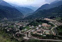
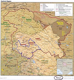
Ramban district is an administrative district in the Jammu division of Indian-administered Jammu and Kashmir in the disputedKashmir region.[1] It is located in a valley surrounded the Pir Panjal range. It was carved out as a separate district from erstwhile Doda district in 2007.[6] It is located in the Jammu division. The district headquarters are at Ramban town, which is located midway between Jammu and Srinagar on the banks of the Chenab river on National Highway-44, approximately 151km from Jammu and Srinagar.[7]
Each tehsil has its tehsildar, who is the administrative head. The district consisted of 116 census villages and 127 revenue villages in 2001. The total number of panchayat Halqas in the district was 124.
District Development Council Ramban
In the elections for Ramban's District Development Council, Shamshad Begum was elected chairman and Rabiya Beigh was elected vice-chairman.[9]
Geography
Ramban district is 1,156 metres (3,792 feet) above sea level (on average). The boundary lines of Ramban district encompass hill station Patnitop as its southernmost point, Assar on its eastern edge, Gool to the west, and Banihal to the north. The terrain of district Ramban is tough and hilly. District Ramban shares its boundary with Reasi, Udhampur, Doda, Anantnag and Kulgam districts.[6]
Climate
The climate of the district varies according to altitude. The temperature rises as high as 42°C in the low-lying areas like Ramban town located in between steep mountains on the banks of Chenab River and drops to sub-zero in high-altitude areas like Sangaldan, Gool, Dhagantop, Asthanmarg, Lalagundi, Budhan, Pogal, Paristan, Neel. The working season in most of the district is about eight months because of weather conditions in the district.
Politics
Ramban district has two assembly constituencies: Ramban and Banihal.[10]
On 21 January 2021, Ramban district was declared a 'terrorist free' district in Jammu and Kashmir.[11]
Demographics
Historical populations
Year
Pop.
±%
1901
46,580
—
1911
50,305
+8.0%
1921
51,062
+1.5%
1931
57,361
+12.3%
1941
61,720
+7.6%
1951
71,242
+15.4%
1961
80,764
+13.4%
1971
105,767
+31.0%
1981
130,569
+23.4%
1991
168,962
+29.4%
2001
214,944
+27.2%
2011
283,713
+32.0%
source:[12] † 1951 and 1991 populations are estimated
According to the 2011 census, Ramban district has a population of 283,713.[14] roughly equal to the nation of Barbados.[15] This gives it a ranking of 573rd in India (out of a total of 640).[14] The district has a population density of 213 inhabitants per square kilometre (550/sqmi) .[14] Its population growth rate over the decade 2001-2011 was 31.81%.[14] Ramban has a sex ratio of 902 females for every 1000 males,[14] and a literacy rate of 54.27%. 4.16% of the population lives in urban areas. Scheduled Castes and Scheduled Tribes make up 4.91% and 14.02% of the population respectively.[14]
Ramban district: religion, gender ratio, and% urban of population, according to the 2011 Census.[13]
Hindu
Muslim
Christian
Sikh
Buddhist
Jain
Other
Not stated
Total
Total
81,026
200,516
414
753
43
3
252
706
283,713
28.56%
70.68%
0.15%
0.27%
0.02%
0.00%
0.09%
0.25%
100.00%
Male
43,844
104,078
253
427
24
2
132
372
149,132
Female
37,182
96,438
161
326
19
1
120
334
134,581
Gender ratio (% female)
45.9%
48.1%
38.9%
43.3%
44.2%
33.3%
47.6%
47.3%
47.4%
Sex ratio (no. of females per 1,000 males)
848
927
–
763
–
–
–
898
902
Urban
5,087
6,224
70
405
1
1
1
22
11,811
Rural
75,939
194,292
344
348
42
2
251
684
271,902
% Urban
6.3%
3.1%
16.9%
53.8%
2.3%
33.3%
0.4%
3.1%
4.2%
Sex Ratio in Ramban District in 2011 Census.[13] (no. females per 1,000 males)
Kashmiri is the largest language in the district, spoken by Muslims predominantly, making up nearly half of the Banihal tehsil. Poguli is also spoken in the Pogal Paristan area of Banihal which is named as Poguli, a very distinct language placed under the dardic group as classified by Sir Grierson in Linguistic Survey of India 1918 contributes nearly 17% of the population. In Ramban tehsil is spoken Dogri and Pahadi languages. Nepali and Pahadi are the main languages of Hindus in Banihal, while Dogri is a major language in Ramban.[16]
12 The application of the term "administered" to the various regions of Kashmir and a mention of the Kashmir dispute is supported by the tertiary sources (a) through (d), reflecting due weight in the coverage. Although "controlled" and "held" are also applied neutrally to the names of the disputants or to the regions administered by them, as evidenced in sources (f) through (h) below, "held" is also considered politicized usage, as is the term "occupied," (see (i) below). (a) Kashmir, region Indian subcontinent, Encyclopaedia Britannica, retrieved 15 August 2019 (subscription required) Quote: "Kashmir, region of the northwestern Indian subcontinent ... has been the subject of dispute between India and Pakistan since the partition of the Indian subcontinent in 1947. The northern and western portions are administered by Pakistan and comprise three areas: Azad Kashmir, Gilgit, and Baltistan, the last two being part of a territory called the Northern Areas. Administered by India are the southern and southeastern portions, which constitute the state of Jammu and Kashmir but are slated to be split into two union territories."; (b) Pletcher, Kenneth, Aksai Chin, Plateau Region, Asia, Encyclopaedia Britannica, retrieved 16 August 2019 (subscription required) Quote: "Aksai Chin, Chinese (Pinyin) Aksayqin, portion of the Kashmir region, at the northernmost extent of the Indian subcontinent in south-central Asia. It constitutes nearly all the territory of the Chinese-administered sector of Kashmir that is claimed by India to be part of the Ladakh area of Jammu and Kashmir state."; (c) "Kashmir", Encyclopedia Americana, Scholastic Library Publishing, 2006, p.328, ISBN978-0-7172-0139-6 C. E Bosworth, University of Manchester Quote: "KASHMIR, kash'mer, the northernmost region of the Indian subcontinent, administered partlv by India, partly by Pakistan, and partly by China. The region has been the subject of a bitter dispute between India and Pakistan since they became independent in 1947"; (d) Osmańczyk, Edmund Jan (2003), Encyclopedia of the United Nations and International Agreements: G to M, Taylor & Francis, pp.1191–, ISBN978-0-415-93922-5 Quote: "Jammu and Kashmir: Territory in northwestern India, subject to a dispute betw een India and Pakistan. It has borders with Pakistan and China." (e) Talbot, Ian (2016), A History of Modern South Asia: Politics, States, Diasporas, Yale University Press, pp.28–29, ISBN978-0-300-19694-8 Quote: "We move from a disputed international border to a dotted line on the map that represents a military border not recognized in international law. The line of control separates the Indian and Pakistani administered areas of the former Princely State of Jammu and Kashmir."; (f) Kashmir, region Indian subcontinent, Encyclopaedia Britannica, retrieved 15 August 2019 (subscription required) Quote: "... China became active in the eastern area of Kashmir in the 1950s and has controlled the northeastern part of Ladakh (the easternmost portion of the region) since 1962."; (g) Bose, Sumantra (2009), Kashmir: Roots of Conflict, Paths to Peace, Harvard University Press, pp.294, 291, 293, ISBN978-0-674-02855-5 Quote: "J&K: Jammu and Kashmir. The former princely state that is the subject of the Kashmir dispute. Besides IJK (Indian-controlled Jammu and Kashmir. The larger and more populous part of the former princely state. It has a population of slightly over 10 million, and comprises three regions: Kashmir Valley, Jammu, and Ladakh.) and AJK ('Azad" (Free) Jammu and Kashmir. The more populous part of Pakistani-controlled J&K, with a population of approximately 2.5 million. AJK has six districts: Muzaffarabad, Mirpur, Bagh, Kodi, Rawalakot, and Poonch. Its capital is the town of Muzaffarabad. AJK has its own institutions, but its political life is heavily controlled by Pakistani authorities, especially the military), it includes the sparsely populated "Northern Areas" of Gilgit and Baltistan, remote mountainous regions which are directly administered, unlike AJK, by the Pakistani central authorities, and some high-altitude uninhabitable tracts under Chinese control." (h) Fisher, Michael H. (2018), An Environmental History of India: From Earliest Times to the Twenty-First Century, Cambridge University Press, p.166, ISBN978-1-107-11162-2 Quote: "Kashmir’s identity remains hotly disputed with a UN-supervised “Line of Control” still separating Pakistani-held Azad (“Free”) Kashmir from Indian-held Kashmir."; (i) Snedden, Christopher (2015), Understanding Kashmir and Kashmiris, Oxford University Press, p.10, ISBN978-1-84904-621-3 Quote:"Some politicised terms also are used to describe parts of J&K. These terms include the words 'occupied' and 'held'."
This page is based on this Wikipedia article Text is available under the CC BY-SA 4.0 license; additional terms may apply. Images, videos and audio are available under their respective licenses.