
Newlyn is a seaside town and fishing port in south-west Cornwall, England, United Kingdom. It is the largest fishing port in England.

Advent is a civil parish on the north-western edge of Bodmin Moor in north Cornwall, England, United Kingdom. The English name St Adwenna derives from the Cornish Adhwynn and lies in the Registration District of Camelford.
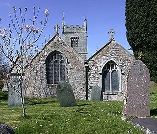
Colan is a village and civil parish in mid-Cornwall, England, United Kingdom. It is situated approximately three miles (5 km) east of Newquay. The electoral ward is called Colan and Mawgan. The population of this ward at the 2011 census was 4,256 The hamlets of Bosoughan, Chapel, Gwills, Kestle Mill, Lane, Mountjoy, Quintrell Downs, Trebarber and Trencreek are in the parish. The Fir Hill, and Firhill Woods near Nanswhyden, contains the ruins of Fir Hill Manor. Colan Church dates back to the thirteenth century.
St Newlyn East is a civil parish and village in Cornwall, England, United Kingdom. The village is approximately three miles (5 km) south of Newquay. The name St Newlyn East is locally abbreviated to Newlyn East and according to an anonymous historian writing in The Cornishman in 1880 it was only in recent years that Saint had been added to the parish name.

Cubert is a village in Cornwall, England, United Kingdom. It is three miles (5 km) south-southwest of Newquay and is in the civil parish of Cubert.

New Mill is a small settlement in west Cornwall, England. It is approximately 2 miles (3.2 km) north of Penzance on the road to Gurnard's Head.
Borlase is a surname and masculine given name.
Ball is a hamlet on the outskirts of Wadebridge in north Cornwall, England, United Kingdom.

Barcelona is a hamlet in the parish of Pelynt in southeast Cornwall, England, UK.

Carland Cross is a location in Cornwall, England, United Kingdom, about six miles north of Truro at OS grid reference OS grid ref SW846539. At Carland Cross there are a hamlet, a road junction and a large wind farm. The road junction is in the civil parish of St Erme, very close to the boundary with St Newlyn East.

Merther is a small hamlet and former civil parish, now in the parish of St Michael Penkevil, in the Cornwall district, in the ceremonial county of Cornwall, England. It lies 2 miles (3 km) east of Truro, on the eastern side of the Tresillian River. In 1931 the parish had a population of 150. It was formerly the churchtown of the small parish of Merther, and also the site of a manor house and medieval chapel dedicated to St Cohan. The former parish church is now in ruins.

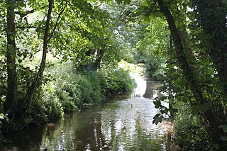
The De Lank River is a small river in north Cornwall, England. It is a tributary of the River Camel and is approximately nine miles (14.5 km) long from its source on Bodmin Moor to its confluence with the Camel two miles (3 km) south of St Breward.

New Mills is a hamlet in Cornwall, England, United Kingdom. It is situated in a wooded valley north of Ladock approximately seven miles (11 km) northeast of Truro at OS grid reference SW899523.

Carloggas is a hamlet in the parish of Mawgan-in-Pydar, Cornwall, England.

Gummow's Shop is a hamlet in the civil parish of St Newlyn East in mid Cornwall, England, UK. It is on the A3058 road southeast of Kestle Mill. Before 1938, there was a blacksmith in the building now known as "The Old Smithy". It is in the civil parish of Cubert
Gwills is a hamlet in the parish of Colan, Cornwall, England. According to the Post Office the population at the 2011 census was included in the civil parish of Gunwalloe

Hendra is the name of eight hamlets in Cornwall, England, United Kingdom.
Higher Tolcarne is a hamlet in Cornwall, England]. It is near St Mawgan; Tolcarne was one of the two Cornish manors of this name recorded in the Domesday Book, 1086. It is in the civil parish of Mawgan in Pydar

Rose is a hamlet in mid-Cornwall, UK. Rose is to the north-west of Goonhavern and east of Perranporth.
Perran Round is an amphitheatre in the hamlet of Rose, midway between the villages of Goonhavern and Perranporth, Cornwall, UK. It is described as the best surviving example of a plen-an-gwary, a medieval amphitheatre used for performing the Ordinalia, or Cornish miracle plays, and Cornish wrestling tournaments.
