Townships in Montgomeryshire

Last updated
The County of Montgomery WalesMontgomeryshireTrad.png
The County of Montgomery
Montgomery Town Hall - A Meeting Place of the Montgomeryshire Court of Great Sessions Montgomery Town Hall - geograph.org.uk - 98025.jpg
Montgomery Town Hall - A Meeting Place of the Montgomeryshire Court of Great Sessions

Townships in Montgomeryshire are divisions of the ancient parishes of the county of Montgomery. In 1539 townships were grouped together in Hundreds. [1] [2] The Townships which were recognised were based on the older Welsh divisions of Tref, or plural Trefi, which had formed the Welsh administrative districts of the Commote. Not all of the former Tref were recognised and some smaller trefi were amalgamated into larger townships. A township was allocated to a particular parish—that is, one of the [civil] parishes of Wales (analogous to civil parishes of England), the predecessors to today's communities of Wales. The townships were recognised as administrative districts, rather than the parishes.

Contents

Townships in Montgomeryshire

The Townships have been mapped by Murray Chapman. [3] The Townships were grouped into Hundreds, and this formed the basis for the Montgomeryshire Court of Great Sessions. The Court met for the first time in 1541, and established the civil and criminal administration of the new County of Montgomeryshire and also arranged for the election of the Member of Parliament for Montgomeryshire. A Mr Sulyard was appointed as surveyor to define the new counties and presumably agree the new townships. [4] The number of Trefi were reduced and many were grouped together. An example is the township named Trefor and Ffin in Kerry. In the large township of Rhandir in Llandyssil parish, the trefi of Coed-wig, Trefganol and Cefn-y-coed were all merged. Many names of Trefi were lost, but some are noted in Melville Richards study of administrative units. [5] The exact extent of many townships can be recovered from many of the Enclosure Awards, but for some Montgomeryshire parishes such as Llangynog the information appears to be missing.

Townships have been studied in Wales and the Marches by Dorothy Sylvester. She has shown that in Montgomeryshire and North West Wales Parishes were normally larger in the Medieval period and would contain many townships, while in Southern and Western Wales, parishes would be smaller and often the extent of the Township will coincide with that of the parish. [6] Sylvester notes that in 1811 there were 53 parishes in Montgomeryshire, with an average size of 15.8 square miles, making them larger than most parishes in other Welsh counties. There were about 239 townships, with an average of 4.5 per parish. [7] Some Montgomeryshire township were within ecclesiastical parishes which were outside County. This is particularly the case along the Montgomeryshire Shroshire border and Sylvester’s figures may have to be modified. The pattern of local government for Montgomeryshire based on the Township, Hundred and the Court of Great Sessions survived until 1830, when the Court of Great Sessions was abolished [8] while the Assises and Quarter Sessions remained. The responsibilities of Townships further declined with the establishment of the Poor Law Unions in 1834, which were organised on a parish basis. Townships in Montgomeryshire finally disappeared as a recognised administrative unit with the establishment of the Montgomeryshire County Council in 1886 and the Rural District Councils in 1894. [9]

Administration of Townships

As the pattern of administration evolved in Elizabethan and later times, the Welsh Township was expected to have its own Court House (sometimes called a Plas), and to provide a pinfold, stocks and butts for archery. They were also responsible for Vagabonds and Paupers. Two Parish Constables were appointed each year for the administration of Justice. The maintenance of roads and bridges was also a responsibility of the Township, [10] but this was reduced in 1819, when Thomas Penson was appointed as the first County Surveyor for Montgomeryshire. The Militia in the earlier period would be raised by the Hundred with the townships contributing. The Court House would normally be the main residence in the Township and the occupier of the house was likely to be a Justice of the Peace. With the establishment of the National Census in 1801, the population counts were on a township rather than parish basis.

Hundreds in Montgomeryshire

Montgomeryshire was initially split into 10 Hundreds, but Clun Hundred was removed by an Act of Parliament in 1546 and included in Shropshire. The following Hundreds were established in 1541

Literature

Listing of Montgomeryshire Townships (after 1541)

Parishes (In1800) by Diocese in Montgomeryshire with their respective Townships. [11] 57 Parishes in total-some Montgomeryshire Townships may be part of parishes in other counties such as Shropshire

Diocese of Bangor

Diocese of Hereford

Diocese of St Asaph

Diocese of St Davids

Related Research Articles

<span class="mw-page-title-main">Montgomeryshire</span> Historic county of Wales

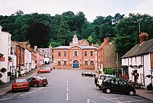
Montgomeryshire, also known as Maldwyn, is one of thirteen historic counties and a former administrative county of Wales. It is named after its county town, Montgomery, which in turn is named after one of William the Conqueror's main counsellors, Roger de Montgomerie, who was the 1st Earl of Shrewsbury.

<span class="mw-page-title-main">Ruabon</span> Village in Wales

Ruabon is a village and community in Wrexham County Borough, Wales. The name comes from Rhiw Fabon, rhiw being the Welsh word for "slope" or "hillside" and Fabon being a mutation from St Mabon, the original church name, of earlier, Celtic origin. An older English spelling, Rhuabon, can sometimes be seen.

<span class="mw-page-title-main">Commote</span> Welsh medieval land division

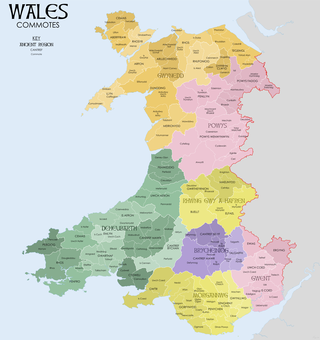
A commote was a secular division of land in Medieval Wales. The word derives from the prefix cym- and the noun bod. The English word "commote" is derived from the Middle Welsh cymwt.

<span class="mw-page-title-main">Pontrobert</span> Parish in the county of Powys, Wales

Pontrobert is an ecclesiastical parish that was formed in September 1854. It comprises the townships of Teirtref and part of Nantymeichiaid in the parish Meifod, a portion of Cynhinfa which was in the parish of Llangynyw and portions of the townships of Fachwel, Llaethbwlch and Cadwnfa which were in the parish of Llanfihangel. The total area of this parish is 5,000 acres. As a result of this arrangement, Pont Robert is now divided between the present day Community Councils of Meifod, Llangyniew and Mawddwy. Pontrobert was within the historic county of Montgomeryshire, now forming part of Powys. The name Pontrobert is derived from Robert ap Oliver of Cyhinfa, who built the original bridge over the River Vyrnwy around 1700. An alternative Welsh name for Pontrobert is Pont y ddolfeiniog.

<span class="mw-page-title-main">Abenbury</span> Community in Wrexham County Borough, Wales

Abenbury is a community in Wrexham County Borough, Wales. It is situated south-east of Wrexham city and includes the village of Pentre Maelor and part of the Wrexham Industrial Estate.

<span class="mw-page-title-main">Cilcain</span> Human settlement in Wales

Cilcain is a village and community, near Mold in Flintshire, north-east Wales. The village has an industrial history and includes the Millennium Woods, a post office, a public house, a parish church, a primary school and a village hall.

<span class="mw-page-title-main">Llanafan Fawr</span> Human settlement in Wales

Llanafan Fawr is a village and community and ecclesiastical parish in the former cantref of Buellt (Builth) and historic county of Brecknockshire in Wales. It is now part of Powys. The community includes the former parish of Llanfihangel Bryn Pabuan.

<span class="mw-page-title-main">Saint Afan</span>

Saint Afan of Builth was an early 6th-century Welsh bishop, martyr, and saint. His feast day is generally placed on 17 November, although the Demetian Calendar formerly used in southern Wales placed it on the 16th; it is no longer observed by either the Anglican or Catholic church in Wales.

<span class="mw-page-title-main">Bacheldre</span> Human settlement in Wales

Bacheldre is a small settlement in Powys, Wales. It is near the A489 road and is 5 kilometres (3 mi) southeast of the town of Montgomery.

Llan and its variants are a common element of Celtic placenames in the British Isles and Brittany, especially of Welsh toponymy. In Welsh an name of a local saint or a geomorphological description follows the Llan morpheme to form a single word: for example Llanfair is the parish or settlement around the church of St. Mair. Goidelic toponyms end in -lann.

<span class="mw-page-title-main">Grwyne Fawr</span> River in south Wales

The Grwyne Fawr is a river in the Brecon Beacons National Park in south Wales. A section of it forms the administrative border between Powys and Monmouthshire and also of the historic counties of Brecon and Monmouth. The river and its major tributary the Grwyne Fechan flow into the River Usk at Glangrwyney.

<span class="mw-page-title-main">Llanfynydd, Flintshire</span> Village in Flintshire, Wales

Llanfynydd is a village, local government community and electoral ward in Flintshire, Wales. Its name is derived from the Welsh words llan, and mynydd ("mountain").

<span class="mw-page-title-main">Forden</span> Human settlement in Wales

Forden is a village near Welshpool in Powys, Wales, formerly in the historic county of Montgomeryshire. It forms part of the community of Forden, Leighton and Trelystan with the neighbouring settlements of Trelystan, Leighton and Kingswood.

Llandyssil is a village in Powys, Wales, about two miles from the town of Montgomery.

<span class="mw-page-title-main">Manafon</span> Human settlement in Wales

Manafon is a small rural community located in the hills of Montgomeryshire, the Northern part of the Welsh county of Powys. The Parish focuses on the valley of the River Rhiew that runs west to east into the River Severn". The community of Manafon consists of "two main villages within about a mile of one another, Manafon and New Mills. The remainder of the population lives in scattered farms and dwellings and in the small rural settlement of The Green."

<span class="mw-page-title-main">Llanfechan</span> Human settlement in Wales

Llanfechan is a small church settlement in the community of Treflys, consisting of a church and a farm, and the surrounding area, it is beside the A483 on the north side of the Irfon Valley near Cilmeri, about 7 kilometers (4.3 mi) west of Builth Wells, Powys, Wales.

References

  1. ”Chapman” (1999), 48-9
  2. ”Chapman” (2012), 48-9
  3. (Chapman M) Map of Montgomeryshire and Western Shropshire showing Townships, Printed map published by the Powysland Club, c1990
  4. "Chapman", 2010, 138.
  5. "Richards", 1969
  6. Sylvester D., (1969), The Rural Landscape of the Welsh Borderland: A Study in Historical Geography, Macmillan, London pp 166-175, fig 22.
  7. "Sylvester", pg. 168, Table VII
  8. "Chapman", (2010), 141
  9. Morris E R in “Jenkins’’, pp. 65-6
  10. "Montgomeryshire collections relating to Montgomeryshire and its borders. | Vol. 69 | 1981 | Welsh Journals - the National Library of Wales".
  11. Parish and Diocese listing based on T W Pritchard in “Jenkins” (1999), 73, Map
  12. It is uncertain which townships were in this parish and which were in Pennant Melangell