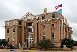
Logan County is a county located in the U.S. state of Oklahoma. As of the 2020 census, the population was 49,555. Its county seat is Guthrie.

Cimarron County is the westernmost county in the U.S. state of Oklahoma. Its county seat is Boise City. As of the 2020 census, its population was 2,296, making it the least-populous county in Oklahoma; and indeed, throughout most of its history, it has had both the smallest population and the lowest population density of any county in Oklahoma. Located in the Oklahoma Panhandle, Cimarron County contains the only community in the state (Kenton) that observes the Mountain Time Zone. Black Mesa, the highest point in the state, is in the northwest corner of the county. The Cimarron County community of Regnier has the distinction of being the driest spot in Oklahoma ranked by lowest annual average precipitation, at just 15.62 inches; at the same time, Boise City is the snowiest location in Oklahoma ranked by highest annual average snowfall, at 31.6 inches.

Cimarron Hills is an unincorporated community and a census-designated place (CDP) located in and governed by El Paso County, Colorado, United States. Cimarron Hills is an enclave of the City of Colorado Springs. The CDP is a part of the Colorado Springs, CO Metropolitan Statistical Area. The population of the Cimarron Hills CDP was 19,311 at the United States Census 2020. The Colorado Springs post office serves the area.

Felt is a small unincorporated community and census-designated place (CDP) in Cimarron County, Oklahoma, United States. As of the 2020 census, the town’s population was 77. It was named for C.F.W. Felt of the Santa Fe Railroad. Nearby is the Cedar Breaks Archeological District, included on the National Register of Historic Places listings in Cimarron County, Oklahoma. The community is served by a post office and a school. During the Great Depression in 1936 a farm in Felt was the site of the iconic Dust Bowl photograph known as Dust Bowl Cimarron County, Oklahoma.

Kenton is a town in Cimarron County, Oklahoma, United States. As of the 2020 census, the community had 31 residents.

Twin Lakes is a pair of glacier-carved alpine lakes about 15 miles (24 km) south of historic Leadville, Colorado. They are downstream along the Arkansas River, whose headwaters are by Leadville. The lakes, however, are on a tributary, Lake Creek, which joins the Arkansas just below the lakes. After dredging, the lakes now have a surface area of 2,700 acres (11 km2), and they serve as a reservoir to store water for use in the Front Range. Both east and west lakes are recreation areas for boating and fishing.
Verdunville is an unincorporated community and census-designated place (CDP) in Logan County, West Virginia, United States. It is 3.5 miles (5.6 km) west of Logan, the county seat. Verdunville has a post office with ZIP code 25649. The Verdunville CDP includes the neighboring community of Shegon. As of the 2010 census, the total CDP population was 687.
Stollings is an unincorporated community and census-designated place (CDP) in central Logan County, West Virginia, United States. As of the 2010 census, it had a population of 316.

Chippewa Park is a census-designated place in Stokes Township, Logan County, Ohio, United States. As of the 2020 census, the population was 819.
Lake City is an unincorporated community and census-designated place (CDP) in Moultrie County, Illinois, United States. As of the 2020 United States census, it had a population of 69.

Beaver Dam Lake is a census-designated place (CDP) in the towns of New Windsor, Blooming Grove, and Cornwall in Orange County, New York, United States. As of the 2020 census, it had a population of 2,609.
Twin Lakes is an unincorporated community and census-designated place (CDP) in Twin Lakes and Sherman townships in Calhoun County, Iowa, United States. As of the 2010 census it had a population of 334.
Shorehaven is a census-designated place (CDP) in the town of Pawling in Dutchess County, New York, United States. It was first listed as a CDP prior to the 2020 census.
Cedar Lake is an unincorporated community and census-designated place (CDP) in Canadian County, Oklahoma, United States. It was first listed as a CDP prior to the 2020 census.
Barber is an unincorporated community and census-designated place (CDP) in Cherokee County, Oklahoma, United States, in the Cherokee Nation. It was first listed as a CDP prior to the 2020 census.
Lovell is a census-designated place (CDP) in Logan County, Oklahoma, United States. It was first determined by the United States Census Bureau prior to the 2020 census. It is named after the village of Lovell, which is incorporated in its boundaries.
Crescent Springs is an unincorporated community and census-designated place (CDP) in Logan County, Oklahoma, United States. It was first listed as a CDP prior to the 2020 census.
Mehan is an unincorporated community and census-designated place (CDP) in Payne County, Oklahoma, United States. It was first listed as a CDP prior to the 2020 census.
Canadian Shores is an unincorporated community and census-designated place (CDP) in Pittsburg County, Oklahoma, United States. It was first listed as a CDP prior to the 2020 census.
Mill Run is an unincorporated community and census-designated place (CDP) in Blair County, Pennsylvania, United States. It was first listed as a CDP prior to the 2020 census.


