
The San Francisco Peninsula is a peninsula in the San Francisco Bay Area that separates San Francisco Bay from the Pacific Ocean. On its northern tip is the City and County of San Francisco. Its southern base is Mountain View, south of Palo Alto and north of Sunnyvale and Los Altos. Most of the Peninsula is occupied by San Mateo County, between San Francisco and Santa Clara counties, and including the cities and towns of Atherton, Belmont, Brisbane, Burlingame, Colma, Daly City, East Palo Alto, El Granada, Foster City, Hillsborough, Half Moon Bay, La Honda, Loma Mar, Los Altos, Menlo Park, Millbrae, Pacifica, Palo Alto, Pescadero, Portola Valley, Redwood City, San Bruno, San Carlos, San Mateo, South San Francisco, and Woodside.

Menlo Park is a city at the eastern edge of San Mateo County within the San Francisco Bay Area of California in the United States. It is bordered by San Francisco Bay on the north and east; East Palo Alto, Palo Alto, and Stanford to the south; and Atherton, North Fair Oaks, and Redwood City to the west. It had 33,780 residents at the 2020 United States census. It is home to the corporate headquarters of Meta, and is where Google, Roblox Corporation and Round Table Pizza were founded. The train station holds the record as the oldest continually operating train station in California. It is one of the most educated cities in California and the United States; nearly 70% of residents over 25 have earned a bachelor's degree or higher.

East Palo Alto is a city in San Mateo County, California, United States. As of the 2020 census, the population of East Palo Alto was 30,034. It is situated on the San Francisco Peninsula, roughly halfway between the cities of San Francisco and San Jose. To the north and east is the San Francisco Bay, to the west is the city of Menlo Park, and to the south the city of Palo Alto. Despite being called "East" Palo Alto, the city is directly north of Palo Alto. While often incorrectly assumed to be part of the city of Palo Alto, East Palo Alto has always been a separate entity since its founding as an unincorporated community and its incorporation in July 1983. It is also in San Mateo County, while Palo Alto is in Santa Clara County. The two cities are separated only by San Francisquito Creek and, largely, the Bayshore Freeway. The revitalization projects in 2000, and high income high-tech professionals moving into new developments, including employees from Google and Facebook, have begun to slowly eliminate the historically wide cultural and economic differences between the two cities. East Palo Alto and Palo Alto share both telephone area codes and postal ZIP codes.

Redwood City is a city on the San Francisco Peninsula in Northern California's Bay Area, approximately 27 miles (43 km) south of San Francisco, and 24 miles (39 km) northwest of San Jose. Redwood City's history spans its earliest inhabitation by the Ohlone people to being a port for lumber and other goods. The county seat of San Mateo County in the heart of Silicon Valley, Redwood City is home to several global technology companies including Oracle, Electronic Arts, Evernote, Box, and Informatica. The city's population was 84,292 according to the 2020 census. The Port of Redwood City is the only deepwater port on San Francisco Bay south of San Francisco.
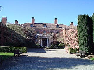
Filoli, also known as the Bourn-Roth Estate, is a country house set in 16 acres (6.5 ha) of formal gardens surrounded by a 654-acre (265 ha) estate, located in Woodside, California, about 25 miles (40 km) south of San Francisco, at the southern end of Crystal Springs Reservoir, on the eastern slope of the Santa Cruz Mountains. Now owned by the National Trust for Historic Preservation, Filoli is open to the public. The site is both a California Historical Landmark and listed on the National Register of Historic Places.

El Palo Alto is a coast redwood located on the banks of the San Francisquito Creek in Palo Alto, California, a city in the San Francisco Bay Area. The namesake of the city and a historical landmark, El Palo Alto is 1082–1083 years old and stands 110 feet (34 m) tall.

A California Historical Landmark (CHL) is a building, structure, site, or place in the U.S. state of California that has been determined to have statewide historical landmark significance.
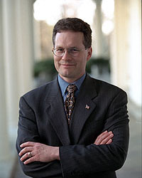
Ruben Barrales is the former Deputy Assistant to President George W. Bush, and was also the Director of the Office of Intergovernmental Affairs. He then served as the CEO of the San Diego Regional Chamber of Commerce. He is currently the President and CEO of GROW Elect, a political action committee that recruits, endorses, trains, and funds Latino Republican candidates for public office. He also serves on the board of directors for the Public Policy Institute of California. Barrales has also run as a candidate for the state government post of California State Controller.
Ravenswood High School was a public high school located in East Palo Alto, California, United States. Opened in 1958, it served the East Palo Alto area of San Mateo County until its closure in 1976. In 1958 its enrollment was 629 students. During the existence of Ravenswood, East Palo Alto was the low-income area in the shadow of its more affluent neighbors Menlo Park, Atherton and Palo Alto. The city of Palo Alto, while adjacent and sharing the same zip code, is a completely different city in Santa Clara County. Ravenswood was part of the Sequoia Union High School District, which also serves the southern San Mateo County cities of Belmont, Redwood City, San Carlos, and Woodside.

Adobe Creek, historically San Antonio Creek, is a 14.2-mile-long (22.9 km) northward-flowing stream originating on Black Mountain in the Santa Cruz Mountains. It courses through the cities of Los Altos Hills, Los Altos, and Palo Alto on its way to the Palo Alto Flood Basin and thence to southwestern San Francisco Bay in Santa Clara County, California, United States. Historically, Adobe Creek was a perennial stream and hosted runs of steelhead trout entering from the Bay, but these salmonids are now blocked by numerous flood control structures, including a tidal gate at the creek's mouth and a long concretized rectangular channel culminating in an impassable drop structure at El Camino Real. The co-founders of Adobe Systems both lived on Adobe Creek.
In the United States, Canada, Australia, and elsewhere, a pioneer cemetery is a cemetery that is the burial place for pioneers. American pioneers founded such cemeteries during territorial expansion of the United States, with founding dates spanning, at least, from the late 18th to early 20th centuries.

The San Mateo County History Museum is located in downtown Redwood City, California. Housed inside the former courthouse built in 1910 for the San Mateo County Superior Court, the museum showcases the rich history of San Mateo County and the surrounding area. Operations and funding for the museum are by the San Mateo County Historical Association (SMCHA).
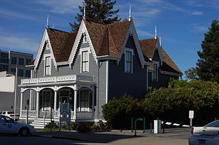
The Lathrop House, also known as the Lathrop-Connor-Mansfield House, was built in Redwood City, California and is one of the San Francisco Peninsula's oldest mansions. Mary C. Lathrop, wife of Benjamin G. Lathrop, bought the land for the 11 room house in 1858 and construction was completed in 1863. The museum has historically existed in three locations, within a few blocks radius in Redwood City.
Sarah Wallis, also known as Sarah Armstrong Montgomery Green Wallis (1825–1905) was an early Anglophone settler in California and first President of the California Woman Suffrage Educational Association.
John Howell Sears (1823–1907) was an early pioneer of Searsville and La Honda, two cities in San Mateo County, California. He directly influenced the development of these cities.

The Woodside Store also called Tripp Store, sits at 3300 Tripp Road at Kings Mountain Road, Woodside, San Mateo County, California. This building has been listed on the National Register of Historic Places since 1985 and is listed as a California Historical Landmark in San Mateo County since 1949. It was preserved through the efforts of the San Mateo Historical Association in the 1940s. After being taken under the wing of the Association in 1979, it was subject to a substantial restoration during the mid-1980s, which was completed by 1994.
The Peninsula Times Tribune was a daily newspaper serving Palo Alto, Redwood City, and neighboring cities in the San Francisco Peninsula of California. It was published by the Tribune Newspaper Company from 1979 to 1993.

The Redwood City Historic Commercial Buildings is an historic district in Redwood City, California that comprises four buildings constructed from 1859-1912. These buildings include the Pioneer Store, the Bank of San Mateo County building, the Sequoia Hotel, and the Alhambra Theater.


