
Petit Jean State Park is a 3,471-acre (1,405 ha) park in Conway County, Arkansas managed by the Arkansas Department of Parks and Tourism. It is located atop Petit Jean Mountain adjacent to the Arkansas River in the area between the Ouachita Mountains and Ozark Plateaus.

Multnomah Falls is a waterfall located on Multnomah Creek in the Columbia River Gorge, east of Troutdale, between Corbett and Dodson, Oregon, United States. The waterfall is accessible from the Historic Columbia River Highway and Interstate 84. Spanning two tiers on basalt cliffs, it is the tallest waterfall in the state of Oregon at 620 ft (189 m) in height. The Multnomah Creek Bridge, built in 1914, crosses below the falls, and is listed on the National Register of Historic Places.

The Rogue River in southwestern Oregon in the United States flows about 215 miles (346 km) in a generally westward direction from the Cascade Range to the Pacific Ocean. Known for its salmon runs, whitewater rafting, and rugged scenery, it was one of the original eight rivers named in the Wild and Scenic Rivers Act of 1968. Beginning near Crater Lake, which occupies the caldera left by the explosive volcanic eruption and collapse of Mount Mazama, the river flows through the geologically young High Cascades and the older Western Cascades, another volcanic province. Further west, the river passes through multiple exotic terranes of the more ancient Klamath Mountains. In the Kalmiopsis Wilderness section of the Rogue basin are some of the world's best examples of rocks that form the Earth's mantle. Near the mouth of the river, the only dinosaur fragments ever discovered in Oregon were found in the Otter Point Formation, along the coast of Curry County.

The South Umpqua River is a tributary of the Umpqua River, approximately 115 miles (185 km) long, in southwestern Oregon in the United States. It drains part of the Cascade Range east of Roseburg. The river passes through a remote canyon in its upper reaches then emerges in the populated South Umpqua Valley east of Canyonville.
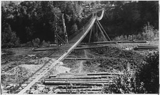
The Rogue River Wars were an armed conflict in 1855–1856 between the U.S. Army, local militias and volunteers, and the Native American tribes commonly grouped under the designation of Rogue River Indians, in the Rogue River Valley area of what today is southern Oregon. The conflict designation usually includes only the hostilities that took place during 1855–1856, but there had been numerous previous skirmishes, as early as the 1830s, between European American settlers and the Native Americans, over territory and resources.
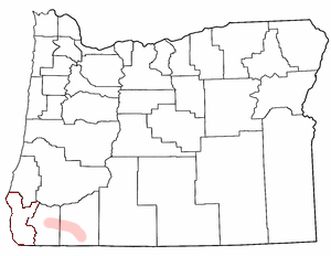
Agness is an unincorporated community in Curry County, Oregon, United States. It is near the confluence of two Wild and Scenic rivers—the Lower Rogue and the Illinois. Agness post office was established October 16, 1897. It was named after Agnes, the daughter of the first postmaster, and subsequently misspelled. The Agness area is popular for fishing and hiking. Agness is in the Rogue River–Siskiyou National Forest and was threatened by the Biscuit Fire in 2002.

Belknap Springs is an unincorporated community and private hot springs resort in Lane County, Oregon, United States, near the McKenzie River. The springs were located and initially developed by R. S. Belknap in 1869. A post office named "Salt Springs" was established in the location in 1874, and the name changed to "Belknap Springs" in 1875. The post office closed in 1877 and reopened in 1891, operating intermittently until 1953. Today the location uses a McKenzie Bridge mailing address.

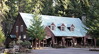
National Park Service rustic – sometimes colloquially called Parkitecture – is a style of architecture that developed in the early and middle 20th century in the United States National Park Service (NPS) through its efforts to create buildings that harmonized with the natural environment. Since its founding in 1916, the NPS sought to design and build visitor facilities without visually interrupting the natural or historic surroundings. The early results were characterized by intensive use of hand labor and a rejection of the regularity and symmetry of the industrial world, reflecting connections with the Arts and Crafts movement and American Picturesque architecture.
Breitenbush is an unincorporated community in Marion County, Oregon, United States, located approximately 10 miles NE of Detroit, Oregon, and 10 miles NW of Mt. Jefferson. The community is situated on private land, encompassed entirely by the Willamette National Forest, and is notable for having several hot springs, both nearby and on the property. It is said to have been originally homesteaded in 1888, and its hot springs have seen varied degrees of development and use since that time. In its heyday as a resort, the community was served by a post office, which operated between 1928 and 1953.

Odell Lake is located near Willamette Pass in the northwest corner of Klamath County, Oregon, United States. It is one of several lakes in the Cascade Range in Central Oregon, and lies within the Deschutes National Forest. It was named for Oregon Surveyor General William Holman Odell by Byron J. Pengra, in July 1865, while they were making a preliminary survey for the Oregon Central Military Road, which would later become Oregon Route 58. The lake fills a basin carved by a glacier, and the resulting terminal moraine confines the water along the lake's southeast shore.

The Rogue River Ranch is a pioneer farm complex in Curry County in southwest Oregon, United States. The ranch is located on the north shore of the Rogue River just outside the Rogue River-Siskiyou National Forest. The original ranch buildings were constructed by George Billings. Later, the ranch was sold to Stanley Anderson, who increased the size of the property and built additional farm buildings. The Bureau of Land Management bought the ranch in 1970. Today, the main ranch house is a museum. The Bureau of Land Management also maintains a campground on the property. The Rogue River Ranch is listed on the National Register of Historic Places.
Union Creek is an unincorporated community in Jackson County in the U.S. state of Oregon. It is located along Union Creek and Oregon Route 62, about 15 miles (24 km) from Crater Lake National Park. The community is home to the Union Creek Historic District, which has been listed on the National Register of Historic Places since 1980.

The Rogue River in the U.S. state of Oregon begins at Boundary Springs on the border between Klamath and Douglas counties near the northern edge of Crater Lake National Park. The Rogue River flows generally west for 215 miles (346 km) from the Cascade Range through the Rogue River – Siskiyou National Forest and the Klamath Mountains to the Pacific Ocean at Gold Beach. Communities along its course include Union Creek, Prospect, Trail, Shady Cove, Gold Hill, and Rogue River, all in Jackson County; Grants Pass, and Galice in Josephine County, and Agness, Wedderburn and Gold Beach in Curry County. Significant tributaries include the South Fork Rogue River, Elk Creek, Bear Creek, the Applegate River, and the Illinois River. Arising at 5,320 feet (1,622 m) above sea level, the river loses more than 1 mile (1.6 km) in elevation by the time it reaches the Pacific.
Marial is an unincorporated community and the site of a former post office in Curry County, Oregon, United States. Located along the Rogue River about 48 miles (77 km) from its mouth on the Pacific Ocean, the area was home to Takelma Indians, then to white and Karok settlers, before becoming part of a designated wilderness. Buildings preserved at the Rogue River Ranch pioneer farm complex, listed on the National Register of Historic Places, represent the former center of Marial. Nearby are the Tucker Flat Campground and a riverside lodge named Marial.

McCredie Springs are hot springs and a former resort in Lane County, Oregon, United States. It is located near Oregon Route 58, 10.7 miles (17.2 km) east of Oakridge, and 50.7 miles (81.6 km) east of Eugene, within the Willamette National Forest. It is known for the nearby natural hot springs along Salt Creek.

Rocky Point is an unincorporated community in Klamath County, Oregon, United States. It is on Pelican Bay on the west shore of Upper Klamath Lake, about 29 miles (47 km) northwest of Klamath Falls and about 3 miles (5 km) north of Oregon Route 140 on Forest Highway 34. It is within the Winema National Forest.

Union Creek is a 15-mile (24 km) long tributary of the Rogue River in the U.S. state of Oregon. Beginning west of Union Peak in the Cascade Range, it flows through the Rogue River – Siskiyou National Forest to meet the Rogue at Union Creek and the Union Creek Historic District.
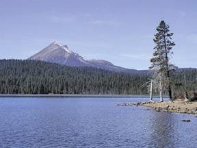
Lake of the Woods is a natural lake near the crest of the Cascade Range in the Fremont–Winema National Forest in southern Oregon in the United States. The lake covers 1,146 acres (4.64 km2). It was named by Oliver C. Applegate in 1870. Today, the Oregon Department of Fish and Wildlife manages the lake's fishery. The small unincorporated community of Lake of the Woods is located on the east shore of the lake. Lake of the Woods is one of southern Oregon's most popular outdoor recreation sites.
Architects of the National Park Service are the architects and landscape architects who were employed by the National Park Service (NPS) starting in 1918 to design buildings, structures, roads, trails and other features in the United States National Parks. Many of their works are listed on the National Register of Historic Places, and a number have also been designated as National Historic Landmarks.
Table Rock is an unincorporated community in Jackson County, Oregon, United States. It lies near the Rogue River along Table Rock Road between White City and Sams Valley. The topographic features known as Upper and Lower Table Rock are slightly west of the community. Between 1853 and 1856, the Table Rock Indian Reservation lay between Upper Table Rock and Evans Creek, a Rogue River tributary to the west.

