
The New Orleans metropolitan area, designated the New Orleans–Metairie metropolitan statistical area by the U.S. Office of Management and Budget, or simply Greater New Orleans, is a metropolitan statistical area designated by the United States Census Bureau encompassing seven Louisiana parishes—the equivalent of counties in other U.S. states—centered on the city of New Orleans. The population of Greater New Orleans was 1,271,845 in 2020, up from 1,189,166 at the 2010 United States census. Greater New Orleans is the most populous metropolitan area in Louisiana, and the 45th most populous in the United States. According to 2017 census estimates, the broader New Orleans–Metairie–Slidell combined statistical area (CSA) had a population of 1,510,562.

The Lynchburg Metropolitan Statistical Area is a United States Metropolitan Statistical Area (MSA) in the state of Virginia, as defined by the Office of Management and Budget (OMB) as of June 2003. As of the 2000 census, the MSA had a population of 228,616. In 2009 this was estimated to have risen to 247,447; as of 2016, the Lynchburg MSA was estimated to have a population of 260,320, making it the fifth-largest metro area in the state.

The Roanoke Metropolitan Statistical Area is a Metropolitan Statistical Area (MSA) in Virginia as defined by the United States Office of Management and Budget (OMB). The Roanoke MSA is sometimes referred to as the Roanoke Valley, even though the Roanoke MSA occupies a larger area than the Roanoke Valley. It is geographically similar to the area known as the Roanoke Region of Virginia, but while the latter includes Alleghany County, the former does not. As of the 2020 census, the MSA had a population of 315,251.

The Clarksville Metropolitan Statistical Area is defined by the United States Census Bureau as an area consisting of four counties – two in Tennessee and two in Kentucky – anchored by the city of Clarksville, Tennessee. The 2021 estimate placed the population at 329,864. As of 2020, the Clarksville Metropolitan Statistical Area was the 159th largest MSA in the United States.

The Houma–Bayou Cane–Thibodaux metropolitan area, officially the Houma–Bayou Cane–Thibodaux metropolitan statistical area, is a Metropolitan Statistical Area in the Acadiana region of southern Louisiana, United States that covers two parishes—Lafourche and Terrebonne. The metropolis had a 2020 census-tabulated population of 207,137.

The Lake Charles metropolitan statistical area is a metropolitan area in the Acadiana region of southwest Louisiana that covers three parishes—Calcasieu, Cameron, and Jefferson Davis. According to a 2023 census estimate, the MSA had a population of 240,082. It is also part of the larger Lake Charles–DeRidder combined statistical area which had a population of 276,909 in 2023. The Lake Charles MSA also shares borders with the Beaumont–Port Arthur metropolitan area to the west. Metropolitan Lake Charles, the principal city, is commonly referred to as the Lake Area.

The Hattiesburg Metropolitan Statistical Area is a metropolitan statistical area (MSA) in southeastern Mississippi that covers three counties - Forrest, Lamar, and Perry. The MSA's principal city is Hattiesburg. The 2010 census placed the Hattiesburg MSA's population at 162,410, though estimates as of 2019 indicate the population has increased to 168,849. The area is part of the geographical region known as the Pine Belt, famous for its abundance of longleaf pine trees. The Hattiesburg MSA is part of the larger Hattiesburg-Laurel Combined Statistical Area.

The Gulfport–Biloxi Metropolitan Statistical Area is a metropolitan statistical area (MSA) in the Mississippi Gulf Coast region that includes four counties – Hancock, Harrison, Jackson and Stone. The principal cities are Gulfport and Biloxi. The 2010 census placed the Gulfport-Biloxi MSA population at 388,488, though as of 2019, it was estimated to have increased to 417,665. The area was significantly impacted by Hurricane Katrina on August 29, 2005, and prior to the hurricane, had experienced steady to moderate population growth. However, growth has since rebounded, with the population steadily increasing every year throughout the 2010s.

The Kalamazoo–Portage Metropolitan Area comprises a region surrounding Kalamazoo. 2015 estimates placed it as the 151st largest among similarly designated areas in the United States. 2015 estimates place the combined statistical area 85th among similarly designated areas.

The Wichita Falls metropolitan statistical area is a metropolitan area in North Texas that covers three counties – Archer, Clay, and Wichita. As of the 2010 census, the MSA had a population of 151,306.

The Corpus Christi metropolitan statistical area is a metropolitan area in South Texas that covers three counties–Aransas, Nueces, and San Patricio. As of the 2000 census, the MSA had a population of 413,280.
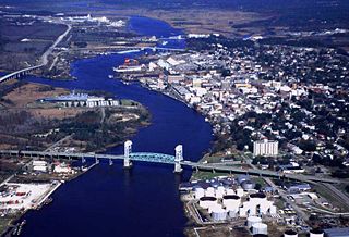
Cape Fear is a coastal plain and Tidewater region of North Carolina centered about the city of Wilmington. The region takes its name from the adjacent Cape Fear headland, as does the Cape Fear River which flows through the region and empties into the Atlantic Ocean near the cape. Much of the region's populated areas are found along the Atlantic beaches and the Atlantic Intracoastal Waterway, while the rural areas are dominated by farms and swampland like that of the Green Swamp. The general area can be also identified by the titles "Lower Cape Fear", "Wilmington, NC Metropolitan Statistical Area", "Southeastern North Carolina", and "Azalea Coast". The latter name is derived from the North Carolina Azalea Festival held annually in Wilmington. Municipalities in the area belong to the Cape Fear Council of Governments.
College Station–Bryan is a metropolitan area centering on the twin cities of Bryan and College Station, Texas, in the Brazos Valley region of Texas. The 2010 census placed the population of the three-county metropolitan area at 255,519. The 2019 population estimate was 273,101.

The Lubbock metropolitan area is a metropolitan statistical area (MSA) in the South Plains region of West Texas, United States, that covers three counties – Crosby, Lubbock, and Lynn. As of the 2010 census, the Lubbock MSA had a population of 290,805, though a 2019 estimate placed the population at 322,257, which ranks it the 157th-most populated MSA in the United States. It is also part of the larger Lubbock–Plainview combined statistical area.

The Brunswick metropolitan area is the Coastal Georgian metropolitan statistical area centered on the principal city of Brunswick, Georgia. The U.S. Office of Management and Budget, Census Bureau and other entities define Brunswick's metropolitan statistical area as comprising Glynn, Brantley, and McIntosh counties, including the cities of Brunswick and Darien. According to the 2020 census, the metropolitan area had a population of 113,495.

The Hinesville metropolitan area, officially the Hinesville metropolitan statistical area and previously the Hinesville–Ft. Stewart metropolitan statistical area, is defined by the U.S. Office of Management and Budget as a metropolitan statistical area consisting of two counties, Liberty and Long, in the U.S. state of Georgia. It is anchored by the city of Hinesville and encompasses all of Fort Stewart, one of the largest U.S. Army installations in the United States.

As defined by the U.S. Office of Management and Budget and used by the U.S. Census Bureau for statistical purposes only, the Florence Metropolitan Statistical Area, is an area consisting of two counties in the Pee Dee region of northeastern South Carolina, anchored by the city of Florence. As of the 2000 census, the MSA had a population of 193,155.

The Columbus metropolitan area, officially the Columbus metropolitan statistical area, and colloquially known as the Chattahoochee Valley, is a metropolitan statistical area consisting of six counties in the U.S. state of Georgia and one county in Alabama, anchored by the city of Columbus.

The Savannah metropolitan area, officially named the Savannah metropolitan statistical area by the U.S. Office of Management and Budget, is a metropolitan statistical area in the U.S. state of Georgia. It is centered on the city of Savannah and encompasses three counties: Bryan, Chatham, and Effingham.

The Hilton Head Island metropolitan area, officially the Hilton Head Island–Bluffton–Port Royal, SC Metropolitan Statistical Area as defined by the United States Census Bureau, is a metropolitan statistical area consisting of the two southernmost counties in the Lowcountry region of South Carolina, centered on the resort town of Hilton Head Island. As of the 2020 census, the MSA had a population of 215,908. Prior to March 2013, the region was considered a micropolitan statistical area.

