
The Bluebell Railway is an 11 mi (17.7 km) heritage line almost entirely in West Sussex in England, except for Sheffield Park which is in East Sussex. It is managed by the Bluebell Railway Preservation Society. It uses steam trains which operate between Sheffield Park and East Grinstead, with intermediate stations at Horsted Keynes and Kingscote.

Central is a heritage-listed railway station located in the centre of Sydney, New South Wales, Australia. The station is the largest and busiest railway station in Australia and serves as a major transport interchange for NSW TrainLink inter-city rail services, Sydney Trains commuter rail services, Sydney light rail services, bus services, and private coach transport services. The station is also known as Sydney Terminal. The property was added to the New South Wales State Heritage Register on 2 April 1999. It recorded 85.4 million passenger movements in 2018.

Severn Tunnel Junction railway station is a minor station on the western side of the Severn Tunnel in the village of Rogiet, Monmouthshire, Wales. It is 123.5 miles (198.8 km) from London Paddington and lies at the junction of the South Wales Main Line from London and the Gloucester to Newport Line.

The East Coastway line is a railway line along the south coast of Sussex to the east of Brighton, England. Trains to the west of Brighton operate on the West Coastway line. Together with the West Coastway and the Marshlink line to the east, the line forms part of a continuous route from Havant to Ashford. The Brighton Main Line route to Eastbourne and Hastings, via Plumpton and Cooksbridge, shares the East Coastway line east of Lewes station.

Chesterfield railway station serves the town of Chesterfield in Derbyshire, England. It lies on the Midland Main Line. Four tracks pass through the station which has three platforms. It is currently operated by East Midlands Railway.

Penarth railway station is the railway station serving the town of Penarth in the Vale of Glamorgan, South Wales. It is the terminus of Network Rail's Penarth branch running from Cogan Junction to Penarth station, 1 mile 12 chains from the junction and 2 miles 67 chains south of Cardiff Central station. The Penarth branch ran from Cogan Junction to Biglis Junction, a rail mileage of 5 miles 65 chains and was officially closed beyond Penarth after the last passenger train ran on Saturday 4 May 1968.

Leicester Central was a railway station in Leicester, England. It was situated to the west of the city centre, on Great Central Street which is today just off the inner ring road. It was closed in 1969.

The 8.38 miles (13.49 km) Tawa Flat deviation is a double-track section of the Kapiti Line just north of Wellington, New Zealand with two tunnels; the southernmost section of the North Island Main Trunk railway (NIMT) between Wellington and Auckland. It was built to bypass a limited capacity single track section of the original Wellington and Manawatu Railway (WMR) line which ascended from Wellington to Johnsonville and then descended to Tawa Flat. The original name of Tawa Flat was changed to Tawa in 1959.
The Didcot, Newbury and Southampton Railway (DN&SR) was a cross-country railway running north–south between Didcot, Newbury and Winchester. Its promoters intended an independent route to Southampton and envisaged heavy traffic from the Midlands and North of England to the port, but they ran out of funds to complete the line to Southampton. The intended heavy through traffic never materialised, and the line was dependent on larger railways—the Great Western Railway and the London and South Western Railway—for support, which was not freely given. The line opened in two stages, in 1882 and 1885.

The Devon and Somerset Railway (D&SR) was a cross-country line that connected Barnstaple in Devon, England, to the network of the Bristol and Exeter Railway (B&ER) near Taunton. It was opened in stages between 1871 and 1873 and closed in 1966. It served a mostly rural area although it carried some through services from east of Taunton to the seaside resort of Ilfracombe.

There are eleven disused railway stations between Exeter St Davids and Plymouth Millbay, Devon, England. At eight of these there are visible remains. Of the eleven stations, South Brent and Plympton are subject of campaigns for reopening while Ivybridge station was replaced by another station on a different site.
The Meon Valley Railway was a cross-country railway in Hampshire, England, that ran for 22 miles between Alton and Fareham, closely following the course of the River Meon. At its northern (Alton) end, it joined with the Alton Line from London. It was conceived as an additional main line to the area around Gosport, and it was opened in 1903. It never fulfilled its planned potential, and remained a local line through sparsely populated agricultural areas, and it closed to passenger services in 1955; some local goods services continued until total closure in 1968.
The Queensbury lines was the name given to a number of railway lines in West Yorkshire, England, that linked Bradford, Halifax and Keighley via Queensbury. All the lines were either solely owned by the Great Northern Railway (GNR) or jointly by the GNR and the Lancashire and Yorkshire Railway (L&YR). The terrain was extremely challenging for railway construction, and the lines were very expensive to build. The lines were

Privett station was an intermediate station on the Meon Valley line which ran from Alton to Fareham during the first half of the 20th century. Named after the hamlet of Privett, the station was in fact over half a mile from its namesake and was built in largely uninhabited countryside.
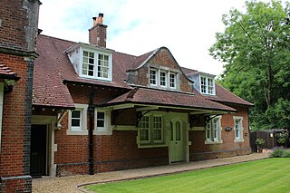
Droxford railway station was an intermediate station on the Meon Valley Railway, built to a design by T. P. Figgis and opened in 1903. It served the villages of Droxford, Soberton and Hambledon in Hampshire, England. The railway served a relatively lightly populated area, but was built to main line specifications in anticipation of it becoming a major route to Gosport. Consequently, although the station was built in an area with only five houses, it was designed with the capacity to handle 10-carriage trains. It initially proved successful both for the transport of goods and passengers, but services were reduced during the First World War and the subsequent recession, and the route suffered owing to competition from road transport.
The Hainault Loop, originally opened as the Fairlop Loop, is a 6.5-mile (10.5 km) branch line of the Great Eastern Railway (GER). It once connected Woodford on the Ongar branch to Ilford on the Main Line, with an eastward connection for goods, excursions and stock transfers to Seven Kings. The loop opened to freight on 20 April 1903 and to passengers on 1 May 1903. In 1923, the GER was "grouped" into the London & North Eastern Railway (LNER), who provided passenger services until December 1947. After this date, the route was electrified for London Underground services from both the Woodford and Leytonstone directions, the link to Ilford closed, and today it forms the greater part of the Hainault Loop on the Central line, having been served by Tube trains since 1948.
Great Horton railway station was a railway station on the Queensbury-Bradford section of the Queensbury Lines which ran between Bradford, Keighley and Halifax via Queensbury. The station opened for passengers in 1878 and closed on 23 May 1955 but remained open to goods with full staff until 28 June 1965 before it was closed, then demolished and the branch line tracks ripped up.

Spofforth railway station was a station on the Harrogate–Church Fenton line in Spofforth, North Yorkshire.


