
Allens West is a railway station on the Tees Valley Line, which runs between Bishop Auckland and Saltburn via Darlington. The station, situated 8 miles 9 chains east of Darlington, serves the village of Eaglescliffe, Borough of Stockton-on-Tees in County Durham, England. It is owned by Network Rail and managed by Northern Trains.

Penrhyndeudraeth railway station is a railway station serving the small town of Penrhyndeudraeth on the Dwyryd Estuary in Gwynedd, Wales. It is a station on the Cambrian Coast Railway with services between Shrewsbury and Pwllheli via Machynlleth.
Llanwnda railway station served the village of Llanwnda, Gwynedd, Wales.
Uralite Halt was a halt between Milton Range Halt and Cliffe station on the Hundred of Hoo Railway. Built to serve the British Uralite works, it opened in July 1906 and closed on 4 December 1961. The halt was demolished soon after closure.
Albert Road Halt was a railway station in Plymouth in the English county of Devon. It was located between Ford and Devonport Park tunnels.

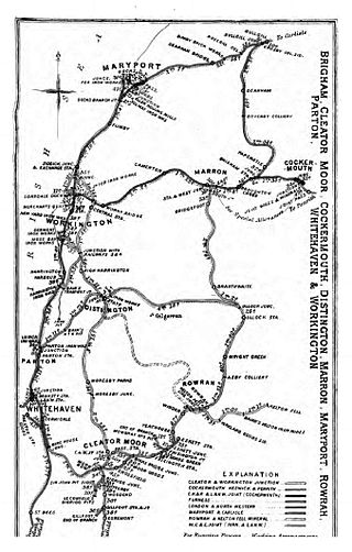
Great Broughton railway station briefly served the village of Great Broughton, near Cockermouth in Cumberland, England.

Shakespeare Cliff Halt is a private halt station on the South Eastern Main Line. It is located to the western end of the dual-bore Shakespeare Cliff tunnel on the South Eastern Main Line to Folkestone, England. It never appeared in any public timetable and has been used successively by railway staff, coal miners, the military and Channel Tunnel workers.

Killingholme Admiralty Platform railway station, known locally as Admiralty Platform, was near North Killingholme Haven, Lincolnshire, England.

Island Road railway station was a railway station at the centre of Barrow Island, Barrow-in-Furness, England which operated between 1899 and 1967. It was built by the Furness Railway near the junction of the Ramsden Branch Line and a line which ran through the industrial areas of the town.
Gillfoot railway station was on the Whitehaven, Cleator and Egremont Railway line half a mile north of Egremont station, in Cumbria, England.
St Thomas Cross Platform was a railway station used by workmen's trains on the Moor Row to Sellafield line on what is now the southeastern, Cringlethwaite, edge of Egremont, Cumbria, England.
Beckermet Mines railway station was situated at Pit No.1 of the mine of the same name. It was used by workmen's trains which travelled along a branch which curved eastwards off the Moor Row to Sellafield line, primarily to handle the iron ore lifted at the site.

Harrington railway station, or Church Road halt, was a railway station in Harrington, Cumbria, England. It was opened by the Cleator and Workington Junction Railway (C&WJR) on the company's Harrington Branch which connected with the Lowca Light Railway at Rosehill to provide a through route from Lowca to Workington Central and beyond.
Camerton Colliery Halt railway station was an unadvertised halt for workers at one or both of the collieries at Camerton, near Cockermouth in Cumberland, England.
Buckhill Colliery Halt railway station was an unadvertised halt for workers at Buckhill Colliery north east of Camerton, near Cockermouth in Cumberland, England.

Parton Halt railway station was opened by the LNWR and FR Joint Railway in January 1915 and closed by the LMSR fourteen years later in 1929.
Dovenby Lodge railway station was on the single track Derwent Branch of the Maryport and Carlisle Railway (M&CR) in the then county of Cumberland, now Cumbria, England.
Allhallows Colliery railway station was in the former county of Cumberland, now Cumbria, England. It was a stop on the Bolton Loop of the Maryport and Carlisle Railway.

Cumberland and Westmorland Convalescent Institution railway station was a terminus off the short Blitterlees Branch off the Carlisle and Silloth Bay Railway, within Silloth itself. The larger railway ran from Carlisle, England. The station does not appear on standard railway maps, but it can be discerned with a magnifying glass on at least two published maps and clearest of all on the 1914 25" OS map.

Holland Road Halt was a railway station in Hove, East Sussex, which opened in 1905 and closed in 1956. It lay to the west of the original Hove station (1840–1880) and to the east of the current station of that name (1865–present) as well as the Cliftonville Curve. It was mainly used during rush hours by stopping trains to Worthing.
