Hampshire is a ceremonial and non-metropolitan county in western South East England on the coast of the English Channel. Home to two major English cities on its south coast, Southampton and Portsmouth, Hampshire is the 9th-most populous county in England. The county town of Hampshire is Winchester, located in the north of the county. The county is bordered by Dorset to the south-west, Wiltshire to the north-west, Berkshire to the north, Surrey to the north-east, and West Sussex to the south east. The county is geographically diverse, with upland rising to 286 m (938 ft) and mostly south-flowing rivers. There are areas of downland and marsh, and two national parks: the New Forest and part of the South Downs, which together cover 45 per cent of Hampshire.

Christchurch is a town and civil parish in Dorset on the south coast of England. The town had a population of 31,372 in 2021. For the borough the population was 48,368. It adjoins Bournemouth to the west, with the New Forest to the east. Part of the historic county of Hampshire, Christchurch was a borough within the administrative county of Dorset from 1974 until 2019, when it became part of the new Bournemouth, Christchurch and Poole unitary authority.

Lymington is a port town on the west bank of the Lymington River on the Solent, in the New Forest district of Hampshire, England. It faces Yarmouth, Isle of Wight, to which there is a car ferry service operated by Wightlink. It is within the civil parish of Lymington and Pennington. The town has a large tourist industry, based on proximity to the New Forest and its harbour. It is a major yachting centre with three marinas. As of 2015, the parish of Lymington and Pennington had a population of 15,726.

Brockenhurst is the largest village by population within the New Forest in Hampshire, England. The nearest city is Southampton some 13 miles (21 km) to the North East, while Bournemouth is also nearby, 15 miles (24 km) South West. Surrounding towns and villages include Beaulieu, Lymington, Lyndhurst, and Sway.
The A31 is a major trunk road in southern England that runs from Guildford in Surrey to Bere Regis in Dorset.

The A35 is a major road in southern England, connecting Honiton in Devon and Southampton in Hampshire. It is a trunk road for some of its length. Most of its route passes through Dorset and the New Forest. It originally connected Exeter and Southampton, the original A35 ran along what is now the A3052 joining the present road at Charmouth.

Lyndhurst is a large village and civil parish situated in the New Forest National Park in Hampshire, England. Serving as the administrative capital of the New Forest, it is a popular tourist attraction, with many independent shops, art galleries, cafés, museums, pubs and hotels. The nearest city is Southampton, about nine miles (14 km) to the north-east. As of 2001 Lyndhurst had a population of 2,973, increasing to 3,029 at the 2011 Census. The name derives from an Old English name, comprising the words lind and hyrst.
Cadnam is a village situated in Hampshire, England, within the boundaries of the New Forest National Park. The village has existed since the medieval period, when it was an important crossroads between Southampton and the towns of Dorset.
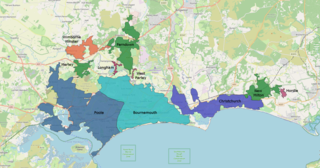
The South East Dorset conurbation is a multi-centred conurbation on the south coast of Dorset in England.

Highcliffe-on-Sea is a seaside town in Dorset in England, administered since April 2019 as part of the unitary authority of Bournemouth, Christchurch and Poole. It forms part of the South East Dorset conurbation along the English Channel coast. The town lies on a picturesque stretch of Solent coastline with views of the Isle of Wight and its 'Needles' rocks. It is part of the historic county of Hampshire.
The Bournemouth Coast Path is a 20-mile-long footpath through Dorset and Hampshire, England from Sandbanks to Milford-on-Sea.

The A338 is a major primary route in southern England, that runs from the junction with the A35 at Poole in Dorset to the junction with the A420 at Besselsleigh in Oxfordshire, a distance of 84 miles (135 km).
Pennington is a ward in the New Forest district of Hampshire, England, which is defined based on the boundaries of the earlier manor. Pennington Village is at the centre of the ward, with Upper Pennington to the north and Lower Pennington to the south. The population taken at the 2011 census was 6,060. It is in the southernmost part of the New Forest on the Solent coastline near to the town of Lymington, with which it shares the civil parish of Lymington and Pennington.

Dorset is a county in South West England. The county is largely rural and therefore does not have a dense transport network, and is one of the few English counties without a motorway. Due to its position on the English Channel coast, and its natural sheltered harbours, it has a maritime history, though lack of inland transport routes have led to the decline of its ports.

The Southampton and Dorchester Railway was an English railway company formed to join Southampton in Hampshire with Dorchester in Dorset, with hopes of forming part of a route from London to Exeter. It received Parliamentary authority in 1845 and opened in 1847. It was promoted by Charles Castleman of Wimborne Minster, and became known as Castleman's Corkscrew because of the meandering route it followed.
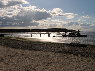
Mudeford is a harbourside and beachside parish based on a former fishing village in the east of Christchurch, Dorset, England, fronting water on two sides: Christchurch Harbour and the sands of Avon Beach.
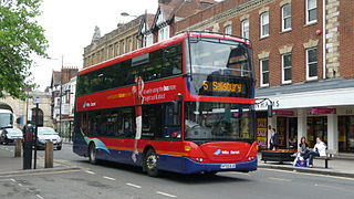
Wilts & Dorset is a bus and coach operator providing services in East Dorset, South Wiltshire, and West Hampshire. It operates services under the morebus brand around Bournemouth and Poole, and under the Salisbury Reds brand around Salisbury and Amesbury. It is part of Go South Coast, a subsidiary of the Go-Ahead Group.

Christchurch is a town and former borough in the county of Dorset on the English Channel coast, adjoining Bournemouth in the west, with the New Forest to the east. Historically in Hampshire, it joined Dorset with the reorganisation of local government in 1974 and is the most easterly borough in the county. Its close proximity to the Cotentin Peninsula made it an important trading port and a potential target for invasion during the Napoleonic and Second World Wars.
Somerford is a district in the unitary authority of Bournemouth, Christchurch and Poole. It lies in the historic county of Dorset. It borders with Mudeford and is intersected by the Somerford Road (B3059). On the north side is an area of residential housing, originally developed as a council estate in the 1950s. The district has three schools: Somerford Infants, Somerford Junior and The Grange School. The present day biggest employer is BAE Systems. Historically, the biggest employers were Airspeed, de Havilland and Gardner's.