Lambeth Road

Last updated

Lambeth Palace's gatehouse on Lambeth Road. LambethPalacebyLambethBridge.jpg
Lambeth Palace's gatehouse on Lambeth Road.
St George's Cathedral main entrance, on the corner of Lambeth Road and St George's Road. St georges roman catholic cathedral southwark.jpg
St George's Cathedral main entrance, on the corner of Lambeth Road and St George's Road.
Imperial War Museum on Lambeth Road. Imperial War Museum Front.JPG
Imperial War Museum on Lambeth Road.

Lambeth Road is a road in Lambeth (to the west) and Southwark (to the east), London running between Lambeth Bridge over the River Thames at the western end and St George's Circus at the eastern end. The road is designated the A3203. The borough boundary runs along it from the intersection with King Edward's Walk to Kennington Road.

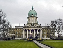
Lambeth Palace, the London base of the Archbishop of Canterbury and the Museum of Garden History are to the north towards the west by the river. St George's Cathedral Southwark is on the north side. Opposite on the south side is the Imperial War Museum, originally the site of the notorious Dog and Duck tavern and later the Bethlem Royal Hospital, the world's oldest psychiatric hospital.

Lambeth Walk adjoins to the south in the middle. Other adjoining roads include the Albert Embankment and Lambeth Palace Road by the river, Kennington Road and St George's Road.

The remains of Saint John Jones were displayed on what is now Lambeth Road after his execution in 1598.

Famous residents

See also notable patients of Bethlem hospital, including the artist Richard Dadd.


Related Research Articles

<span class="mw-page-title-main">London Borough of Southwark</span> Borough in United Kingdom

The London Borough of Southwark in South London forms part of Inner London and is connected by bridges across the River Thames to the City of London and London Borough of Tower Hamlets. It was created in 1965 when three smaller council areas amalgamated under the London Government Act 1963. All districts of the area are within the London postal district. It is governed by Southwark London Borough Council.

<span class="mw-page-title-main">Kennington</span> Area of London, mostly within the London Borough of Lambeth

Kennington is a district in south London, England. It is mainly within the London Borough of Lambeth, running along the boundary with the London Borough of Southwark, a boundary which can be discerned from the early medieval period between the Lambeth and St George's parishes of those boroughs respectively. It is located 1.4 miles (2.3 km) south of Charing Cross in Inner London and is identified as a local centre in the London Plan. It was a royal manor in the parish of St Mary, Lambeth in the county of Surrey and was the administrative centre of the parish from 1853. Proximity to central London was key to the development of the area as a residential suburb and it was incorporated into the metropolitan area of London in 1855.

<span class="mw-page-title-main">Newington, London</span> Human settlement in England

Newington is a district of South London, just south of the River Thames, and part of the London Borough of Southwark. It was an ancient parish and the site of the early administration of the county of Surrey. It was the location of the County of London Sessions House from 1917, in a building now occupied by the Inner London Crown Court.

<span class="mw-page-title-main">London Borough of Lambeth</span> Borough in United Kingdom

Lambeth is a London borough in South London, England, which forms part of Inner London. Its name was recorded in 1062 as Lambehitha and in 1255 as Lambeth. The geographical centre of London is at Frazier Street near Lambeth North tube station, though nearby Charing Cross on the other side of the Thames in the City of Westminster is traditionally considered the centre of London.

<span class="mw-page-title-main">South Bank</span> Human settlement in England

The South Bank is an entertainment and commercial district in central London, England on the south bank of the River Thames opposite the City of Westminster. It forms a narrow strip of riverside land within the London Borough of Lambeth and the London Borough of Southwark,. As such, the South Bank may be regarded as somewhat akin to the riverside part of an area known previously as Lambeth Marsh and North Lambeth.

<span class="mw-page-title-main">Lambeth</span> Human settlement in England

Lambeth is a district in South London, England, in the London Borough of Lambeth. Lambeth was an ancient parish in the county of Surrey. It is situated 1 mile south of Charing Cross. The population of the London Borough of Lambeth was 303,086 in 2011. The area experienced some slight growth in the medieval period as part of the manor of Lambeth Palace. By the Victorian era the area had seen significant development as London expanded, with dense industrial, commercial and residential buildings located adjacent to one another. The changes brought by World War II altered much of the fabric of Lambeth. Subsequent development in the late 20th and early 21st centuries has seen an increase in the number of high-rise buildings. The area is home to the International Maritime Organization. Lambeth is home to one of the largest Portuguese-speaking communities in the UK, and is the second most commonly spoken language in Lambeth after English.

<span class="mw-page-title-main">Lambeth Palace</span> Official London residence of the Archbishop of Canterbury

Lambeth Palace is the official London residence of the archbishop of Canterbury. It is situated in north Lambeth, London, on the south bank of the River Thames, 400 yards south-east of the Palace of Westminster, which houses Parliament, on the opposite bank.

<span class="mw-page-title-main">Metropolitan Borough of Lambeth</span> Metropolitan borough of England

Lambeth was a civil parish and metropolitan borough in south London, England. It was an ancient parish in the county of Surrey. The parish was included in the area of responsibility of the Metropolitan Board of Works in 1855 and became part of the County of London in 1889. The parish of Lambeth became a metropolitan borough in 1900, following the London Government Act 1899, with the parish vestry replaced by a borough council.

<span class="mw-page-title-main">St Thomas' Hospital</span> Hospital in London, England

St Thomas' Hospital is a large NHS teaching hospital in Central London, England. It is one of the institutions that compose the King's Health Partners, an academic health science centre. Administratively part of the Guy's and St Thomas' NHS Foundation Trust, together with Guy's Hospital, King's College Hospital, University Hospital Lewisham, and Queen Elizabeth Hospital, it provides the location of the King's College London GKT School of Medical Education.

<span class="mw-page-title-main">St George's Fields</span>

St George's Fields was an area of Southwark in south London, England.

<span class="mw-page-title-main">Westminster Bridge Road</span>

Westminster Bridge Road is a road in London, England. It runs on an east–west axis and passes through the boroughs of Lambeth and Southwark.

<span class="mw-page-title-main">Kennington Road</span>

Kennington Road is a long straight road, approximately a mile in length, in the London Borough of Lambeth in London, England, running south from Westminster Bridge Road to Kennington Park Road.

<span class="mw-page-title-main">St George's Road</span>

St George's Road is a one-way road in Southwark, London running between Westminster Bridge Road to the northwest and Elephant and Castle to the southeast. The direction of the vehicular traffic is from Elephant and Castle to Westminster Bridge Road. Its name derives from its crossing of St George's Fields, being an open rural area of the parish of St George the Martyr, Southwark. The road was laid out as part of the communications improvements for Westminster Bridge, from the 1740s, connecting the Bridge to the Elephant and Castle junctions with New Kent Road, Walworth Road and Kennington Park Road.

<span class="mw-page-title-main">West Square</span>

West Square is a historic square in south London, England, just south from St George's Road. The square is within the London Borough of Southwark, but as it is located in postcode SE11, it is commonly said to be in Lambeth.

Waterloo is a district in Central London, and part of the Bishops ward of the London Borough of Lambeth. It is situated 1 mile (1.6 km) east of Charing Cross. The area is part of a business improvement district which includes The Cut and the Old Vic and Young Vic theatres. It includes some sections of the London Borough of Southwark.

<span class="mw-page-title-main">Geraldine Mary Harmsworth Park</span>

Geraldine Mary Harmsworth Park is a public park in Kennington, South London. Maintained by the London Borough of Southwark, it is bounded by Lambeth Road, Kennington Road, St George's Road and Brook Drive. It covers an area of 5.9 hectares. The grounds of the park surround its central feature, the Imperial War Museum London.

This is a list of the toponymy of street names in the London district of Vauxhall. The area has no formally defined boundaries – those utilised here are Black Prince Road to the north, Kennington Road to the north-east, Kennington Park Road/Clapham Road to the south-east, Miles Street/Fentiman Road to the south, and Wandsworth Road/Nine Elms Lane/river Thames to the west.

This is a list of the etymology of street names in the London district of Waterloo. The area has no formally defined boundaries – those utilised here are the river Thames to the north and west, Blackfriars Road to the east, and Westminster Bridge Road to the south.

This is a list of the etymology of street names in the London districts of Kennington and Lambeth. The areas have no formally defined boundaries – those utilised here are Westminster Bridge Road/St George's Circus/London Road to the north, Newington Butts/Kennington Park Road to the east, Kennington Road and Black Prince Road to the south and the river Thames to the west.