The M25 or London Orbital Motorway is a major road encircling most of Greater London. The 117-mile (188-kilometre) motorway is one of the most important roads in the UK and one of the busiest. Margaret Thatcher opened the final section in 1986, making the M25 the longest ring road in Europe upon opening. The Dartford Crossing completes the orbital route but is not classed as motorway; it is classed as a trunk road and designated as the A282. In some cases, including notable legal contexts such as the Communications Act 2003, the M25 is used as a de facto alternative boundary for Greater London.

Hounslow is a large suburban district of West London, 10+3⁄4 miles west-southwest of Charing Cross. It is the administrative centre of the London Borough of Hounslow, and is identified in the London Plan as one of the 12 metropolitan centres in Greater London.

The London Borough of Hounslow is a London borough in West London, England, forming part of Outer London. It was created in 1965 when three smaller borough councils amalgamated under the London Government Act 1963. It is governed by Hounslow London Borough Council.
Harlington is a district of Hayes the London Borough of Hillingdon and one of five historic parishes partly developed into London Heathrow Airport and associated businesses, the one most heavily developed being Harmondsworth. It is centred 13.6 miles (21.9 km) west of Charing Cross. The district adjoins Hayes to the north and shares a railway station with the larger district, which is its post town, on the Great Western Main Line. It is in the south-west corner of the historic county of Middlesex.

Harmondsworth is a village in the London Borough of Hillingdon in the historic county of Middlesex with a short border to the south onto London Heathrow Airport. The village has no railway stations, but adjoins the M4 motorway and the A4 road. Harmondsworth is an ancient parish that once included the large hamlets of Heathrow, Longford and Sipson. Longford and Sipson have modern signposts and facilities as separate villages, remaining to a degree interdependent such as for schooling. Its Great Barn and its church are well-repaired medieval buildings in the village. The largest proportion of land in commercial use is related to air transport and hospitality. The village includes public parkland with footpaths and abuts the River Colne and biodiverse land in its Regional Park to the west, once the grazing meadows and woodlands used for hogs of Colnbrook.
Heston is a suburban area and part of the Hounslow district in the London Borough of Hounslow. The residential settlement covers a slightly smaller area than its predecessor farming village, 10.8 miles (17.4 km) west south-west of Charing Cross and adjoins the M4 motorway but has no junction with it; Heston also adjoins the Great West Road, a dual carriageway, mostly west of the "Golden Mile" headquarters section of it. Heston was, historically, in Middlesex.

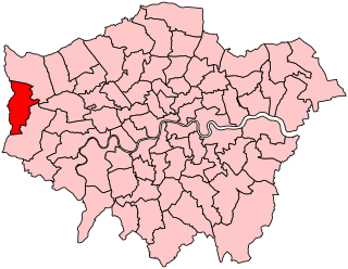
The London Borough of Hillingdon is the largest and westernmost borough in West London, England. It was formed from the districts of Hayes and Harlington, Ruislip-Northwood, Uxbridge, and Yiewsley and West Drayton in the ceremonial county of Middlesex. Today, Hillingdon is home to Heathrow Airport and Brunel University, and is the second largest of the 32 London boroughs by area.
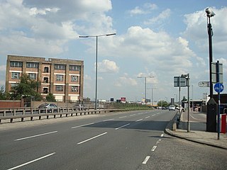
Western Avenue is part of the A40, a major road running in a north-westerly direction out of London. Western Avenue is approximately 10 miles (16 km) long from its junction with Old Oak Common Lane in East Acton.

Longford is a suburban village in the London borough of Hillingdon, England. It is immediately northwest of London Heathrow Airport, which is in the same borough. It is the westernmost settlement in Greater London, close to the borders of Berkshire and Surrey.
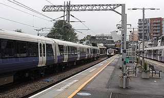
Hayes & Harlington is a railway station serving the west London districts Hayes and Harlington in the London Borough of Hillingdon. It is 10 miles 71 chains down the line from London Paddington and is situated between Southall and West Drayton.
Uxbridge was a seat returning one Member of Parliament (MP) of the House of Commons of the UK Parliament from 1885 to 2010. Its MPs elected were: Conservative Party candidates for 107 years and Labour Party candidates for 18 years. The closing 40 years of the seat's history saw Conservative victory — in 1997 on a very marginal majority in relative terms.

Hayes and Harlington is a constituency in the west of London represented in the House of Commons of the UK Parliament since 1997 by John McDonnell of the Labour Party, who also served as the Shadow Chancellor of the Exchequer from 2015 to 2020.

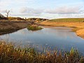
The River Crane, a tributary of the River Thames, runs 8.5 miles (13.6 km) in West London, England. It forms the lower course of Yeading Brook. It adjoins or passes through three London boroughs: Hillingdon, Hounslow and Richmond upon Thames, in the historic county of Middlesex. The drainage basin is heavily urbanised but many of the Hayes to Whitton flood-meadows have been conserved, forming a narrow, green vale, opening out to what remains of Hounslow Heath in the centre – a near-continuous belt of semi-natural habitat.
Hatton including Hatton Cross is a small settlement and locality in the historic County of Middlesex and the London boroughs of Hillingdon and Hounslow, on the south-eastern edge of London Heathrow Airport and straddling the A30 road.

The London Ringways were a series of four ring roads planned in the 1960s to circle London at various distances from the city centre. They were part of a comprehensive scheme developed by the Greater London Council (GLC) to alleviate traffic congestion on the city's road system by providing high speed motorway-standard roads within the capital, linking a series of radial roads taking traffic into and out of the city.

London Buses route 111 is a Transport for London contracted bus route in London, England, running between Heathrow Airport and Kingston. It is operated by Abellio London.

Yeading Brook is the dominant source of the River Crane, in outer North West then West London. The western branch flows 25.8 km (16.0 mi) south. It rises in the far south of suburban Pinner and drains all of the western suburbs of Harrow, insofar as they have not been by historical practice connected into sewers.

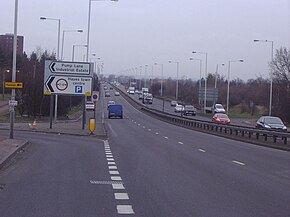
Minet Country Park is a 36-hectare park on Springfield Road, Hayes in the London Borough of Hillingdon; it is situated between the A312 and the Uxbridge Road.

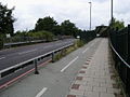
Cranford Countryside Park is a 144-acre public park in Cranford, in the London Borough of Hillingdon, England. Situated in close proximity to Heathrow Airport, it is bordered by the M4 Motorway to the north, the A312 trunk road to the east, and by the towns of Harlington and Cranford to the South West and South East respectively. Although its namesake Cranford is within the London Borough of Hounslow, the park itself is geographically in fact part of the London Borough of Hillingdon, as it straddles the southernmost point of this borough. Although the park is in an urban location, it is vehicle-accessible only by a small road before a motorway entrance slip, and as such it has been described as a 'hidden gem'.