
Carn Euny is an archaeological site near Sancreed, on the Penwith peninsula in Cornwall, United Kingdom with considerable evidence of both Iron Age and post-Iron Age settlement. Excavations on this site have shown that there was activity at Carn Euny as early as the Neolithic period. There is evidence that shows that the first timber huts there were built about 200 BC, but by the 1st century BC, these had been replaced by stone huts. The remains of these stone huts are still visible today.

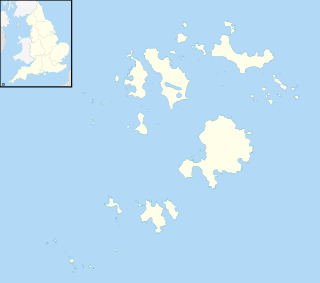
St Mary's is the largest and most populous island of the Isles of Scilly, an archipelago off the southwest coast of Cornwall in England.

Redruth is a town and civil parish in Cornwall, England. The population of Redruth was 14,018 at the 2011 census. In the same year the population of the Camborne-Redruth urban area, which also includes Carn Brea, Illogan and several satellite villages, stood at 55,400 making it the largest conurbation in Cornwall. Redruth lies approximately at the junction of the A393 and A3047 roads, on the route of the old London to Land's End trunk road, and is approximately 9 miles (14 km) west of Truro, 12 miles (19 km) east of St Ives, 18 miles (29 km) north east of Penzance and 11 miles (18 km) north west of Falmouth. Camborne and Redruth together form the largest urban area in Cornwall and before local government reorganisation were an urban district.
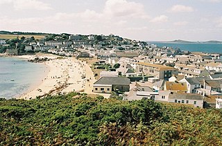
Hugh Town is the largest settlement on the Isles of Scilly and its administrative centre. The town is situated on the island of St Mary's, the largest and most populous island in the archipelago, and is located on a narrow isthmus which joins the peninsula known as the Garrison with the rest of the island.
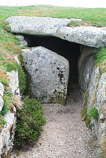
Entrance grave is a type of Neolithic and early Bronze Age chamber tomb found primarily in Great Britain. The burial monument typically consisted of a circular mound bordered by a stone curb, erected over a rectangular burial chamber and accessed by a narrow, stone lined entrance. Entrance graves have been discovered in the Isles of Scilly, west Cornwall, southeast Ireland, southwest Scotland, Brittany and the Channel Islands. They are often referred to as the Scillonian' Group, named for the Scillian Islands where the majority of entrance graves have been discovered.

Bant's Carn is a Bronze Age entrance grave located on a steep slope on the island of St Mary's in the Isles of Scilly, England. The tomb is one of the best examples of a Scillonian entrance grave. Below Bant's Carn, lies the remains of the Iron Age village of Halangy Down.

St Agnes is the southernmost populated island of the Isles of Scilly. Thus the island's Troy Town Farm is the southernmost settlement in the United Kingdom.

St Martin's is the northernmost populated island of the Isles of Scilly, England. It has an area of 237 hectares (0.92 sq mi).

Teän is an uninhabited island to the north of the Isles of Scilly archipelago between Tresco, 1.5 kilometres (0.9 mi) to the west and St Martin's 300 metres (330 yd) to the east. Approximately 16 hectares in area the island consists of a series of granite tors with the highest point, Great Hill, rising to 40 metres (130 ft) at its eastern end. The low-lying land is overlain with glacial till and outwash gravels with glacial erratics abundant on the north coast beaches which indicates the southern limit of outwash from an ice sheet for which it is designated a Geological Conservation Review site.

The Isles of Scilly is an archipelago off the southwestern tip of Cornwall. One of the islands, St Agnes, is the most southerly point in England, being over 4 miles (6.4 km) further south than the most southerly point of the British mainland at Lizard Point.

St Mary's Church, St Mary's is a parish church in the Church of England located in Hugh Town, St Mary's, Isles of Scilly, UK. The Church was consecrated on 7 September 1838 and replaced the church at Old Town which was inconvenient for the Hugh Town population and in need of repair.
The Five Islands Academy, formerly Five Islands School, is the first federated school in the United Kingdom, providing primary and secondary education for children from 3 to 16 at five sites in the Isles of Scilly.
Pelistry is a small settlement, situated east of Maypole and north of Normandy, in the east of the island of St Mary's in the Isles of Scilly, England. The name is first recorded in 1650 as Porthlistrye.

Old Town is a village on St Mary's in the Isles of Scilly located southeast of Hugh Town. It is thought to be the oldest settlement on the island. There is a church, a pub, two cafes, a small convenience shop and a day nursery.

Maypole is a dispersed settlement located on the island of St Mary's, the largest of the Isles of Scilly, England. It is a tourist and farming area, with the only horse riding school in the islands.

The Lower Moors is a wetland between Hugh Town and Old Town Bay on St Mary's, the largest island in the Isles of Scilly. The Isles of Scilly are an archipelago off the southwestern tip of the Cornish peninsula of Great Britain.
Normandy is a small settlement on the island of St Mary's, the largest of the Isles of Scilly, England. It is located in the east of the island, between Pelistry and Porth Hellick on the A3110 road.

Trenoweth is a small settlement, located in the north of the island of St Mary's in the Isles of Scilly, Cornwall, England.

Halangy Down is a prehistoric settlement located on the island of St Mary's, in the Isles of Scilly. The ancient site covers the lower slope of Halangy Down hill, overlooking the coastal inlet between the island of St. Mary's and Tresco Island. On the site are the remains of an Iron Age village, two entrance graves, prehistoric field systems, standing stones, post-medieval breastworks, and a Victorian kelp pit. The settlement was in continuous use for 500 years, from the late Iron Age until the end of the Roman occupation in Britain.

