A360 road

Last updated

UK road A360.svg
A360
The A360, Rollestone - geograph.org.uk - 522643.jpg
The A360 at Rollestone
Route information
Length24 mi (39 km)
Major junctions
North West end Devizes
51°21′13″N1°59′54″W / 51.3537°N 1.9982°W / 51.3537; -1.9982 (A360 road (northern end))
Major intersectionsUK road A342.svg A342
UK road A303.svg A303
UK road A36.svg A36
South East end Salisbury
51°04′21″N1°48′17″W / 51.0724°N 1.8047°W / 51.0724; -1.8047 (A360 road (southern end))
Location
Country United Kingdom
Constituent country England
Road network

The A360 is an A road in Wiltshire, England, running from Devizes to Salisbury, through the villages of Potterne, West Lavington, Tilshead, and Shrewton, and passing near the Stonehenge ancient monument.

Contents

Route

The road is 24 miles (39 km) long and starts at the junction of the A342 and A361 roads in the town of Devizes. It continues southwards towards Salisbury Plain, passing West Lavington via Potterne, then south-east to Shrewton via Tilshead. It turns right at Airman's Corner (a junction with an entrance to Stonehenge and the B3086), crosses the A303 and continues southwards into Salisbury, joining the A36 near the centre of the city. [1]

History

Original route

The A360 originally ran south from Shrewton, following the River Till via Winterbourne Stoke to join the A36 beyond Stapleford. [2] This section was re-routed sometime before 1958, [3] at first eastward for about 2 miles (3 km) along the A344 Amesbury road, then turning south near Stonehenge onto the former Devizes-Salisbury road; [4] a straighter route on higher ground which avoids the riverside villages and heads directly for Salisbury.

Longbarrow Roundabout

In November 2012, major work began on the Longbarrow Roundabout where the A360 crosses the A303, with the intention that the A360 would become the main visitors' route to Stonehenge. [5] In June 2013, the main road next to Stonehenge, the A344, was closed and drivers were advised to access the Stonehenge visitor centre via the A360 instead. [6]

Camp Hill upgrade

In 2019, work began on upgrading a junction with a minor road to a roundabout at Camp Hill near the north-west outskirts of Salisbury, as it is a notorious accident blackspot with several serious incidents. [7]

Features

One of several tank crossings on the A360 Tank crossing place, A360 - geograph.org.uk - 303043.jpg
One of several tank crossings on the A360

The central section of the A360 through Salisbury Plain passes through the centre of Salisbury Plain Training Area, a major Ministry of Defence site. The road crosses several tank trails, which see sporadic active use during training exercises. A number of warning signs are placed on the road advising motorists. [8] In 2018, live firing was stopped on the site after part of Salisbury Plain caught fire, which resulted in part of the A360 being closed. [9]

In addition to Stonehenge, the A360 passes several ancient monuments, including Camp Down, [10] a bowl barrow at Longbarrow. [11]

Related Research Articles

<span class="mw-page-title-main">Wiltshire</span> County of England

Wiltshire is a historic and ceremonial county in South West England with an area of 3,485 km2. It is landlocked and borders the counties of Dorset to the southwest, Somerset to the west, Hampshire to the southeast, Gloucestershire to the north, Oxfordshire to the northeast and Berkshire to the east. The county town was originally Wilton, after which the county is named, but Wiltshire Council is now based in the county town of Trowbridge. Within the county's boundary are two unitary authority areas, Wiltshire and Swindon, governed respectively by Wiltshire Council and Swindon Borough Council.

<span class="mw-page-title-main">A303 road</span> Trunk road in southern England

The A303 is a trunk road in southern England, running between Basingstoke in Hampshire and Honiton in Devon via Stonehenge. Connecting the M3 and the A30, it is part of one of the main routes from London to Devon and Cornwall. It is a primary A road throughout its length, passing through five counties.

<span class="mw-page-title-main">Stonehenge road tunnel</span> Proposed road tunnel

The Stonehenge road tunnel is a planned tunnel in Wiltshire, England, drawn up by Highways England to upgrade the A303 road. It would move the A303 into a tunnel under the Stonehenge World Heritage Site, completing the removal of traffic begun with the 2012 closure of the A344 road. The wider project was designed to improve the landscape around the monument and to improve safety on the A303, and was part of proposals to change the site in other ways including moving the visitors' centre. In 2020, the project was expected to cost £1.7 billion.

<span class="mw-page-title-main">A350 road</span>

The A350 is a north–south primary route in southern England, that runs from the M4 motorway in Wiltshire to Poole in Dorset.

<span class="mw-page-title-main">West Lavington, Wiltshire</span> Human settlement in England

West Lavington is a village and civil parish in Wiltshire, England, on the north edge of Salisbury Plain, on the A360 road between Devizes and Salisbury, about 5 miles (8 km) south of Devizes. The parish includes the hamlet of Littleton Panell.

<span class="mw-page-title-main">A344 road (England)</span> Former A road in Wiltshire, England

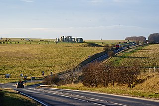
The A344 was an A road in the English county of Wiltshire. Until 2013 it ran from its junction with the A303 at Stonehenge, northwest to its junction with the A360, 2 miles (3 km) away.

<span class="mw-page-title-main">Camp Down</span>

Camp Down is a 7.3-hectare (18-acre) biological Site of Special Scientific Interest in Wiltshire in South West England. It was designated as such in 1965.

<span class="mw-page-title-main">Potterne</span> Human settlement in England

Potterne is a village and civil parish in the county of Wiltshire, England. The village is 2 miles (3.2 km) south of Devizes and lies on the A360 which links Devizes to Salisbury. The civil parish includes the hamlet of Potterne Wick.

<span class="mw-page-title-main">A342 road</span>

The A342 is an A road in England that runs from Pewsham near Chippenham, Wiltshire to Andover, Hampshire.

<span class="mw-page-title-main">A345 road</span>

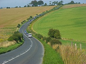
The A345 is a secondary A road in Wiltshire, England running from Salisbury to Marlborough and the A4. The road is a main south–north link across Salisbury Plain, which is renowned for its rich archaeology, and passes many ancient points of interest along its way.

<span class="mw-page-title-main">Urchfont</span> Village in Wiltshire, England

Urchfont is a rural village and civil parish in the southwest of the Vale of Pewsey and north of Salisbury Plain in Wiltshire, England, about 3+12 miles (6 km) southeast of the market town of Devizes. The hamlet of Cuckoo's Corner is in the northwest of the village; the parish includes the hamlets of Wedhampton and Lydeway. The population of the parish at the 2011 census was 1,075.

<span class="mw-page-title-main">Market Lavington</span> Human settlement in England

Market Lavington is a civil parish and large village with a population of about 2,200 on the northern edge of Salisbury Plain in Wiltshire, England, 5 miles (8.0 km) south of the market town of Devizes. The village lies on the B3098 Westbury–Urchfont road which skirts the edge of the Plain. The parish includes the hamlets of Northbrook, Lavington Sands and Fiddington Sands.

<span class="mw-page-title-main">Winterbourne Stoke</span> Human settlement in England

Winterbourne Stoke is a village and civil parish in Wiltshire, England, about 5 miles (8 km) west of Amesbury and 3 miles (4.8 km) west of the prehistoric monument of Stonehenge.

<span class="mw-page-title-main">Shrewton</span> Human settlement in England

Shrewton is a village and civil parish on Salisbury Plain in Wiltshire, England, around 6 miles (9.7 km) west of Amesbury and 14 miles (23 km) north of Salisbury. It lies on the A360 road between Stonehenge and Tilshead. It is close to the source of the River Till, which flows south to Stapleford.

<span class="mw-page-title-main">Tilshead</span> Village and civil parish in Wiltshire, England

Tilshead is a village and civil parish in the county of Wiltshire in Southern England, about 9 miles (14 km) northwest of the town of Amesbury. It is close to the geographical centre of Salisbury Plain, on the A360 road approximately midway between the villages of Shrewton and Market Lavington, and is near the source of the River Till. Its population in 2011 was 358, down from a peak of 989 inhabitants in 1951.

The Amesbury and Military Camp Light Railway was a branch line in Wiltshire, England, constructed under a light railway order dated 24 September 1898. It was opened for military traffic from Amesbury to the east-facing Newton Tony Junction on 1 October 1901. A west-facing junction, Amesbury Junction, where the branch burrowed under the main line, opened on 2 June 1902. The line closed in 1963.

<span class="mw-page-title-main">Roundway</span> Human settlement in England

Roundway is a hamlet and former civil parish adjacent to Devizes in the English county of Wiltshire. The hamlet lies about 1+14 miles (2.0 km) northeast of Devizes town centre.

<span class="mw-page-title-main">Rollestone</span> Human settlement in England

Rollestone is a small village and former civil parish on Salisbury Plain in Wiltshire, England. It is near the River Till. Its nearest town is Amesbury, about 5 miles (8.0 km) away to the east.

References

  1. "A360 : Devizes to Salisbury". Google Maps. Retrieved 10 March 2020.
  2. MOT Map 38 : Southampton, Portsmouth and Isle of Wight (Map). Ordnance Survey. 1923. Retrieved 10 March 2020.
  3. "Ordnance Survey 1:25,000 map, sheet SU04". National Library of Scotland. 1958. Retrieved 26 October 2021.
  4. Historic England. "Milestone, Devizes Road (1318705)". National Heritage List for England . Retrieved 26 October 2021.
  5. "Stonehenge work begins at Longbarrow A303 roundabout". BBC News. 5 November 2012. Retrieved 10 March 2020.
  6. "Stonehenge permanent road closure work begins". BBC News. Retrieved 10 March 2020.
  7. "Roundabout being installed at notorious A360 crossroads". Spire FM. 9 July 2019. Retrieved 10 March 2020.
  8. "Salisbury Plain Training Area" (PDF). Ministry of Defence. July 2017. Retrieved 10 March 2020.
  9. "MoD stop live firing exercise after setting fire to Salisbury Plain". The Daily Telegraph. London. 12 July 2018. Retrieved 10 March 2020.
  10. "Camp Down". Milestones Web. Retrieved 10 March 2020.
  11. "Bowl barrow 400m south east of Longbarrow Cross Roads, east of A360". Ancient Monuments. Retrieved 10 March 2020.
Map all coordinates using: OpenStreetMap  
Download coordinates as: KML

Coordinates: 51°12′31″N1°56′09″W / 51.2086°N 1.9358°W / 51.2086; -1.9358 (A360 road)