
Camp Down (grid reference SU120338 ) is a 7.3-hectare (18-acre) biological Site of Special Scientific Interest in Wiltshire in South West England. It was designated as such in 1965. [1]
Camp Down (grid reference SU120338 ) is a 7.3-hectare (18-acre) biological Site of Special Scientific Interest in Wiltshire in South West England. It was designated as such in 1965. [1]
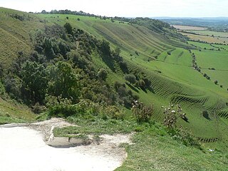
The area overlooks the valley of the River Avon, and is about 3 miles (5 km) northwest of Salisbury. [2] It lies east of the A360 road, which runs from Salisbury to Devizes via Stonehenge. [3]
The down has a chalk grassland that has been well grazed and contains numerous plants, as is typical of grass sites in South Wilshire. Over 20 types of grasses and sedges have been recorded at Camp Down, including red fescue, upright brome, quaking-grass, crested hair-grass and glaucous sedge. The turf contains a variety of herbs, including dwarf thistle and ox-eye daisy. There are a significant number of orchids, particularly Gymnadenia conopsea . [2]
There are a number of young sycamore trees on the site, alongside patches of scrub and scattered bushes. The environment of chalk grassland mixed with scattered scrub means Camp Down is frequented to a number of types of birds and insects. Historical records show there were several types of plant bug and beetle fauna on the site. [2]
Camp Down has seen problems with badgers who are a prominent carrier of tuberculosis. In 2019, Natural England reported that the government would grant a licence for badger culling on the site in the interests of preserving the environment. The action has been controversial, and criticised by the Badger Trust as unnecessarily cruel. [4]

Salisbury Plain is a chalk plateau in southern England covering 300 square miles (780 km2). It is part of a system of chalk downlands throughout eastern and southern England formed by the rocks of the Chalk Group and largely lies within the county of Wiltshire, but stretches into Hampshire.
Beacon Hill is near the village of Burghclere and Watership Down, in north Hampshire. The hill's name is derived from the fact that it was one of many Beacon Hills in England and beyond. This hill was once the site of the most famous beacon in Hampshire. It is 261 metres high and has one of England's most well known hill forts on its slopes, visible from the main A34 road which passes close by. From there, outstanding views of the surrounding area and much of Hampshire may be obtained. The site is open to the public and managed by Hampshire County Council. It is an 80.7-hectare (199-acre) biological Site of Special Scientific Interest called Burghclere Beacon and a Nature Conservation Review site, Grade I.

Bookham Commons are two commons, situated just to the north of the villages of Great Bookham and Little Bookham, in Surrey, England, 154.7 hectares in extent; the individual parts are named Great Bookham Common and Little Bookham Common. A group of dwellings known as the Isle of Wight is situated within the site, and a track, Common Road, leads to it from the northwest. Little Bookham Common lies south and west of this track, whereas Great Bookham Common lies to the east.
Bratton Downs is a 395.8 hectare biological and geological Site of Special Scientific Interest in Wiltshire, England, near the villages of Bratton and Edington, and about 3 miles (5 km) east of the town of Westbury. It was notified in 1971. The designated area consists mainly of chalk grassland, as well as some ancient woodland, and supports a diverse range of native flora and fauna. It overlays notable geological features—principally landforms created by glaciation in the Pleistocene.

Yarnbury Castle is the site of a multiphase, multivallate Iron Age hillfort near the village of Steeple Langford, Wiltshire, England. The site covers an area of 28.5 acres (11.5 ha), and was extensively surveyed and investigated by the Royal Commission on the Historical Monuments of England in 1991, with finds of Iron Age and Romano-British pottery, Iron Age and Roman coins, and burials of human remains. There is much evidence of prolonged and extensive settlement of the site, including evidence of around 130 structures of various sizes, most probably representing a mix of round houses, pits, and other features. It was designated as a scheduled monument in 1925.

Upton Cow Down is a 16.4 hectare biological Site of Special Scientific Interest in Wiltshire. The down is an area of chalk grassland on the western edge of Salisbury Plain. It lies one mile south of the town of Westbury, above the village of Upton Scudamore.
Throope Down is a 34.4 hectare biological Site of Special Scientific Interest in Wiltshire, England, on chalk grassland in Bishopstone parish south-east of Salisbury. The site was notified in 1971 and again in 1986.

Stratford Toney Down is a 23.1 hectare biological Site of Special Scientific Interest in Wiltshire, England, which was notified in 1987. The site lies in a shallow dry valled in the south of Stratford Tony parish, about 5 miles (7.5 km) south-west of Salisbury. It is important for the botanically rich chalk grassland – mainly sheep's fescue and meadow oat-grass – which supports several nationally rare plant and butterfly species.

Bowerchalke Downs, is a 134 hectares biological Site of Special Scientific Interest in southern Wiltshire, England, notified in 1971.

Gallows Hill SSSI is a Site of Special Scientific Interest on the north side of the Ebble Valley in south Wiltshire, England. Its chalk grassland and scrub contain a number of animal and plant species that are nationally rare. The 27.8 hectares site was notified in 1965.
Great Cheverell Hill is a 33.2 hectare biological Site of Special Scientific Interest at Great Cheverell in Wiltshire, notified in 1971.

Porton is a village in the Bourne valley, Wiltshire, England, about 5 miles (8 km) northeast of Salisbury. It is the largest settlement in Idmiston civil parish.

Cassop Vale is a Site of Special Scientific Interest in the Durham City district of County Durham, England. It lies between the villages of Bowburn and Cassop, 7 km south-east of the centre of Durham..

Scratchbury Camp is the site of an Iron Age univallate hillfort on Scratchbury Hill, overlooking the Wylye valley about 1 km northeast of the village of Norton Bavant in Wiltshire, England. The fort covers an area of 37 acres (15 ha) and occupies the summit of the hill on the edge of Salisbury Plain, with its four-sided shape largely following the natural contours of the hill.

Brassey is a 2.1-hectare (5.2-acre) biological Site of Special Scientific Interest in Gloucestershire, notified in 1954 and renotified in 1983. It is situated on the north side of the Windrush Valley, midway between Naunton and Upper Slaughter. The reserve comprises sloping, unimproved limestone pasture. There is a fast-flowing stream. This site is one of the few freshwater marshes in Gloucestershire. The stream joins the River Windrush.

Tudor Farm Bank is a 3.68-hectare (9.1-acre) biological Site of Special Scientific Interest in Gloucestershire, notified in 1999.

Debden Water SSSI is a 20.9-hectare (52-acre) biological Site of Special Scientific Interest which comprises two stretches of Debden Water, a small tributary of the River Cam, and surrounding land. The site is on the eastern outskirts of Newport in Essex, where the stream joins the Cam.

West Harting Down SSSI is a 13.9-hectare (34-acre) biological Site of Special Scientific Interest west of South Harting in West Sussex. It is part of the 317.9-hectare (786-acre) West Harting Down, which is managed by Forestry England.
Farnham Mires is a Site of Special Scientific Interest, or SSSI, to the west of the village of Farnham, North Yorkshire, England. It consists of a spring-fed marshy fen or mire with reeds and sedge, and drier calcareous grassland containing a diverse range of flora. It has a history of poaching and fox hunting, but since the late 19th century, the attention of botanists has been drawn to its large variety of flowering plants. It has received some consideration on this account since 1944, and from 1954 it was designated SSSI status. This site has no facilities, and is not open to the public.

Porton Down SSSI is a 1,559-hectare (3,850-acre) biological Site of Special Scientific Interest which spans the border between Hampshire and Wiltshire in England. It is adjacent to Porton Down science park near Porton, and much of it is Ministry of Defence property which is closed to the public. It is a Nature Conservation Review site, Grade I, a Special Area of Conservation and a Special Protection Area.