
Blackmoor Copse is a woodland in southeast Wiltshire, England, managed as a nature reserve by the Wiltshire Wildlife Trust. The copse lies within Pitton and Farley parish, about 5 1⁄2 miles (9 km) east of Salisbury.
Gripwood Quarry is a 2.9 hectare geological Site of Special Scientific Interest in Wiltshire, England, notified in 1951. The quarry is of Oolitic limestone and has a wall in the middle creating an upper and a lower quarry, last used for mushroom growing. The walls are whitewashed and there is a large wooden crane.
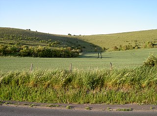
Scratchbury & Cotley Hills SSSI is a 53.5 hectare biological Site of Special Scientific Interest at Norton Bavant in Wiltshire, England, notified in 1951. The Iron Age hillfort of Scratchbury Camp occupies the summit of the hill.
Bradley Woods is an area of woodland in Wiltshire, south of Longleat Woods and north of Gare Hill.
Brickworth Down and Dean Hill is a 118.6 hectare biological Site of Special Scientific Interest in Wiltshire, notified in 1951.
Cockey Down is a 15.2 hectare biological Site of Special Scientific Interest in Wiltshire, notified in 1971.

White Sheet Hill, also known as Whitesheet Hill, is a hill in the English county of Wiltshire. As one of the most westerly areas of downland in Britain the area is noted for its chalky farmland which contains a rich variety of rare and protected fauna and flora. The hill is also the site of a neolithic causeway camp and barrows; and an Iron Age hill fort. The Roman road which runs along the hill was at one time the main route through the Selwood Forest. The hill is part of the Stourhead estate and has been in the ownership of the National Trust since 1946.
Upper Waterhay Meadow is a 2.8 hectare biological Site of Special Scientific Interest in Wiltshire, notified in 1971.

Pewsey Downs is a 305.3 hectare biological Site of Special Scientific Interest on the southern edge of the Marlborough Downs north of Pewsey in Wiltshire, notified in 1951. It includes the Pewsey Downs National Nature Reserve.
Cloatley Manor Farm Meadows is a 12.1 hectare biological Site of Special Scientific Interest in Wiltshire, notified in 1997.
Emmett Hill Meadows is a 5.1 hectare biological Site of Special Scientific Interest in Wiltshire, notified in 1987.
Stoke Common Meadows is a 10.2 hectare biological Site of Special Scientific Interest in Wiltshire, notified in 1994.
Heath Hill Farm is a 20.73 hectare biological Site of Special Scientific Interest near Stourton in Wiltshire, notified in 1997. Part of the Stourhead estate, it is also situated within the Cranborne Chase and West Wiltshire Downs Area of Outstanding Natural Beauty.
Rack Hill is a 10.6 hectare biological Site of Special Scientific Interest in Wiltshire, notified in 1975.

King's Play Hill is a 29.5 hectare biological Site of Special Scientific Interest near Heddington, Wiltshire, notified in 1971.
Great Cheverell Hill is a 33.2 hectare biological Site of Special Scientific Interest at Great Cheverell in Wiltshire, notified in 1971.

Danks Down and Truckle Hill is a 13.1 hectare biological Site of Special Scientific Interest in Wiltshire, notified in 1990.
Restrop Farm and Brockhurst Wood is a 56.5 hectare biological Site of Special Scientific Interest in Wiltshire, notified in 1992. The site contains the Iron Age hill fort of Ringsbury Camp.
Inwood, Warleigh is a 56.9 hectare biological Site of Special Scientific Interest in Wiltshire, notified in 1988.

Cley Hill is a prominent hill to the west of Warminster in Wiltshire, England. Its summit has a commanding view of the Wiltshire / Somerset county boundary, at 244 metres (801 ft) elevation. The land is in Corsley parish and is owned by the National Trust.
This page is based on this
Wikipedia article Text is available under the
CC BY-SA 4.0 license; additional terms may apply.
Images, videos and audio are available under their respective licenses.