Related Research Articles
The Gloucestershire Wildlife Trust is the Gloucestershire local partner in a conservation network of 46 Wildlife Trusts. The Wildlife Trusts are local charities with the specific aim of protecting the United Kingdom's natural heritage. The Gloucestershire Wildlife Trust is managed by a board of trustees elected from its membership who provide overall direction for the development of the trust and there are advisory committees. The work of the trust is carried out through staff and volunteers.

Blackmoor Copse is a woodland in southeast Wiltshire, England, managed as a nature reserve by the Wiltshire Wildlife Trust. The copse lies within Pitton and Farley parish, about 5+1⁄2 miles (9 km) east of Salisbury.

Stratford Toney Down is a 23.1 hectare biological Site of Special Scientific Interest in Wiltshire, England, which was notified in 1987. The site lies in a shallow dry valled in the south of Stratford Tony parish, about 5 miles (7.5 km) south-west of Salisbury. It is important for the botanically rich chalk grassland – mainly sheep's fescue and meadow oat-grass – which supports several nationally rare plant and butterfly species.
Distillery Farm Meadows is an 18.7 hectare biological Site of Special Scientific Interest in Wiltshire, notified in 1988.

Clattinger Farm is a 60.3 hectare biological Site of Special Scientific Interest in Wiltshire, notified in 1971.
Cockey Down is a 15.2 hectare biological Site of Special Scientific Interest in Wiltshire, notified in 1971.

Clout's Wood is an 11.78 hectare biological Site of Special Scientific Interest in Wiltshire, notified in 1951.

Roundway Down and Covert is an 86 hectare biological Site of Special Scientific Interest near Devizes in Wiltshire, England. It was notified in 1971.
Emmett Hill Meadows is a 5.1 hectare biological Site of Special Scientific Interest in Wiltshire, notified in 1987.
Stoke Common Meadows is a biological Site of Special Scientific Interest in north Wiltshire, England. The 10.2 hectare site is in Purton parish, 1.6 miles (2.6 km) west of Purton Common hamlet and 3 miles (5 km) south-west of the town of Cricklade.

Ravensroost Wood is a 43.7 hectare biological Site of Special Scientific Interest in north Wiltshire, England. The site lies about 1.5 miles (2.4 km) south of Minety village and straddles the boundary between Minety and Braydon parishes.

Jones's Mill is an 11.6 hectare biological Site of Special Scientific Interest near Pewsey in Wiltshire, notified in 1975.
Lower Coombe and Ferne Brook Meadows is an 11.34 hectare biological Site of Special Scientific Interest in Wiltshire, England which sits on the Upper Greensand and Gault Clay. The site is home to rare fen meadow and neutral grassland communities in an unimproved grassland. Species such as Triglochin palustris, Caltha palustris and Oenanthe pimpinelloides can be found at the location. Three streams, which form headwaters of the River Nadder flow through the site. It was notified in 2002.
Homington and Coombe Bissett Downs is a 25.0 hectare biological Site of Special Scientific Interest in Wiltshire, notified in 1971.

Cley Hill is a prominent hill to the west of Warminster in Wiltshire, England. Its summit has a commanding view of the Wiltshire / Somerset county boundary, at 244 metres (801 ft) elevation. The land is in Corsley parish and is owned by the National Trust.
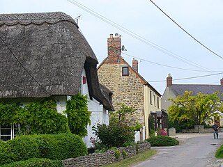
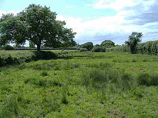
Hinton Parva, also known as Little Hinton, is a village in the Borough of Swindon in Wiltshire, England. It lies about 2 miles (3.2 km) from the eastern edge of the Swindon built-up area, and is separated from the town by farmland and the village of Wanborough. The village has a Grade I listed church which has Norman origins. Hinton Parva was a separate civil parish until 1934, and is now in the parish of Bishopstone.

Bacombe and Coombe Hills is a 76.4-hectare (189-acre) biological Site of Special Scientific Interest in Upper Bacombe in Buckinghamshire. Bacombe Hill was formerly owned by Buckinghamshire County Council, which transferred it to Berkshire, Buckinghamshire and Oxfordshire Wildlife Trust in 2014. Coombe Hill is owned by the National Trust.

Little Wittenham SSSI is a 68.9-hectare (170-acre) biological Site of Special Scientific Interest north-east of Didcot in Oxfordshire. It is also a Special Area of Conservation.

Coombe Wood and The Lythe is a 44-hectare (110-acre) biological Site of Special Scientific Interest west of Bordon in Hampshire. It is part of East Hampshire Hangers Special Area of Conservation and Combe Wood is a National Trust property.
References
- ↑ "The Coombs, Hinton Parva SSSI". Natural England. Retrieved 26 July 2023.
- ↑ "Citation for The Coombes SSSI" (PDF). Natural England. Retrieved 26 July 2023.
- ↑ "The Coombes, Hinton Parva | Wiltshire". National Trust. Retrieved 26 July 2023.
51°32′31″N1°40′21″W / 51.54184°N 1.67263°W
| | This article about a Site of Special Scientific Interest in England is a stub. You can help Wikipedia by expanding it. |
| | This article about a location in Wiltshire is a stub. You can help Wikipedia by expanding it. |