Wicken, Cambridgeshire

Last updated

Wicken
Village
Village Green, Wicken - geograph.org.uk - 331987.jpg
Village Green
Cambridgeshire UK location map.svg
Red pog.svg
Wicken
Location within Cambridgeshire
Population839 
(Including Upware. 2011 Census) [1]
OS grid reference TL568706
District
Shire county
Region
Country England
Sovereign state United Kingdom
Post town ELY
Postcode district CB7
Dialling code 01353
Police Cambridgeshire
Fire Cambridgeshire
Ambulance East of England
List of places
UK
England
Cambridgeshire
52°18′45″N0°17′54″E / 52.3126°N 0.2982°E / 52.3126; 0.2982 Coordinates: 52°18′45″N0°17′54″E / 52.3126°N 0.2982°E / 52.3126; 0.2982

Wicken is a small village on the edge of The Fens near Soham in East Cambridgeshire, ten miles north east of Cambridge and five miles south of Ely. It is the site of Wicken Fen National Nature Reserve.

Contents

Geography

Wicken parish consists principally of fenland covering 1,604 hectares (3,964 acres) in eastern Cambridgeshire. Its western border largely follows the course of the River Cam, and its southern border separating it from Burwell follows the winding Wicken Lode, which flows into Reach Lode just before the latter meets the Cam. A fenland waterway forms its eastern border with Soham parish. Since at least the 10th century the parish has also contained the hamlet of Upware in its isolated south-west corner on the Cam. [2]

History

East Cambridgeshire is known for its great quantity of archaeological findings from the Stone Age, the Bronze Age and the Iron Age. Of Wicken some Bronze Age activity is known as there are a few subsided barrows. [3] Stone Age flint tools, Bronze Age weapons and Roman coinage have also been found in the parish as well as a few spears and other weapons from the Anglo-Saxon era. [2]

Wicken's relative isolation and poverty has meant that several of the late medieval and early modern timber-framed houses survive. The medieval limestone cross which formerly stood on Cross Green was unburied and reinstated there in 1973. [2]

Wicken was listed as Wicha in the Domesday Book [4] and Wiken in around 1200. [5] The name comes from an Old-English dative plural wícum meaning "the dwellings" or "the trading settlement". [6]

Wicken also has the last twelve-sided smock mill still working in England, having been restored to full working order by a team of volunteers. The mill produces various grades and types of flour, milled using windpower driving two sets of burr crystal mill stones. The mill is open during the first weekend of every month and whenever the sails are turning. [7] The mill is a Grade II* listed building. [8]

The village was struck by a tornado on 23 November 1981, as part of the record-breaking nationwide tornado outbreak on that day. [9]

War memorial

Near the village green there is a memorial to the men of the area who died in the two World Wars. The name of Bailey is sadly prominent, with three in the First World War and one in the Second World War. There is also a mention of the 50th anniversary of the Women's Institute (1965).

Church

The church is dedicated to Saint Laurence and is at the eastern end of the village. The newer centre of the village is now some distance away. The church has a nave with three bays, a north and south aisle, a tower that contains five bells, a chancel, a south porch and a large vestry on the north side of the tower. The present building is largely 14th century, with some 13th century stonework. [2]

Interred under the altar are Henry Cromwell, fourth son of Oliver Cromwell along with his wife, some of their children and an unidentified Elizabeth Cromwell.

The church is a Grade II* listed building. [10]

Village life

The village's only public house, The Maid's Head, so named since the mid-18th century, occupied a 15th-century thatched hall house, extended to the west in 1852, until it was hit by a fire in 1983. The building was rebuilt immediately to its original design. Former pubs include The Red Lion, recorded from the late 18th century until it closed in the 1930s, and the Black Horse at the top of Lode Lane, which closed by the 1950s. Upware retains the Five Miles from Anywhere Inn by the river. [2]

The village faces the larger settlement of Soham across a flat expanse of agricultural land, once flooded, and still called Soham Mere.

Recreation ground

The recreation ground is located on Chapel Lane and can be reached by navigating to the postcode CB75XZ. The recreation ground has a MUGA (Multi-use games area), football field with changing rooms and utilities, play equipment, recently added outdoor exercise equipment and zip-wire.

It hosts the popular annual Wicken Beer Festival [11] which is traditionally held on the second Saturday in May of every year.

See also

Related Research Articles

Cambridgeshire County of England

Cambridgeshire is a county in the East of England, bordering Lincolnshire to the north, Norfolk to the north-east, Suffolk to the east, Essex and Hertfordshire to the south, and Bedfordshire and Northamptonshire to the west. The city of Cambridge is the county town. Following the Local Government Act 1972 restructuring, modern Cambridgeshire was formed in 1974 through the amalgamation of two administrative counties: Cambridgeshire and Isle of Ely, comprising the historic county of Cambridgeshire ; and Huntingdon and Peterborough, comprising the historic county of Huntingdonshire and the Soke of Peterborough, historically part of Northamptonshire. Cambridgeshire contains most of the region known as Silicon Fen.

Burwell, Cambridgeshire Village in Cambridgeshire, England

Burwell is a village and civil parish in Cambridgeshire, England, some 10 miles north-east of Cambridge. It lies on the south-east edge of the Fens. Westward drainage is improved by Cambridgeshire lodes (waterways), including Burwell Lode, a growth factor in the village. A population of 6,309 in the 2011 census was put at 6,417 in 2019.

Soham Human settlement in England

Soham is a town and civil parish in the district of East Cambridgeshire, in Cambridgeshire, England, just off the A142 between Ely and Newmarket. Its population was 10,860 at the 2011 census.

Ramsey, Cambridgeshire Human settlement in England

Ramsey is a market town and civil parish in the Huntingdonshire district of Cambridgeshire, England. The town is about 9 miles (14 km) north of Huntingdon. Ramsey parish includes the settlements of Ramsey Forty Foot, Ramsey Heights, Ramsey Mereside, Ramsey Hollow and Ramsey St Mary's.

East Cambridgeshire Non-metropolitan district in England

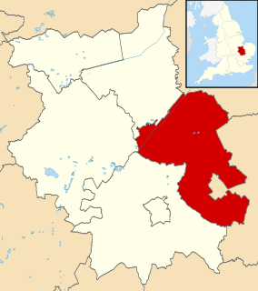
East Cambridgeshire is a local government district in Cambridgeshire, England. Its council is based in Ely. The population of the District Council at the 2011 Census was 83,818.

Whittlesey Town in Cambridgeshire, England

Whittlesey is a market town and civil parish in the Fenland district of Cambridgeshire, England. Whittlesey is 6 miles (10 km) east of Peterborough. The population of the parish was 16,058 at the 2011 Census.

Fordham, Cambridgeshire Human settlement in England

Fordham is a village in rural Cambridgeshire, England. Fordham is part of the East Cambridgeshire district. It is four miles north of Newmarket, as well as being close to the settlements of Soham, Burwell, Isleham, Mildenhall and Chippenham.

Cottenham Human settlement in England

Cottenham is a village in Cambridgeshire, England. Cottenham is one of the larger villages surrounding the city of Cambridge, located around five miles north of the city. The population of the civil parish at the 2011 Census was 6095. Cottenham is one of a number of villages that make up the historical Fen Edge region in between Cambridge and Ely, which were originally settlements on the shore of the marshes close to the city of Cambridge, then an inland port.

Wrangle, Lincolnshire Village in the Boston Borough of Lincolnshire, England

Wrangle is a village in the Boston Borough of Lincolnshire, England. It is situated approximately 9 miles (14 km) north-east from the town of Boston. The population of Wrangle civil parish in 2001 was 1,265, increasing to 1,397 at the 2011 census.

Wicken Fen Nature reserve in Cambridgeshire, United Kingdom

Wicken Fen is a 254.5 hectare biological Site of Special Scientific Interest west of Wicken in Cambridgeshire. It is also a National Nature Reserve, and a Nature Conservation Review site. It is protected by international designations as a Ramsar wetland site of international importance, and part of the Fenland Special Area of Conservation under the Habitats Directive.

Stretham Village located in East Cambridgeshire, England

Stretham is a village and civil parish 4 miles (6 km) south-south-west of Ely in Cambridgeshire, England, about 74 miles (119 km) by road from London. Its main attraction is Stretham Old Engine, a steam-powered pump used to drain the fens. The pump is still in use today although converted to electric power. It has open days throughout the year.

Chippenham, Cambridgeshire Human settlement in England

Chippenham is a village and civil parish in Cambridgeshire, England, part of East Cambridgeshire district around 4 miles (6.4 km) north-east of Newmarket and 10 miles (16 km) north-east of Cambridge.

Horningsea Human settlement in England

Horningsea is a small village north of Cambridge in Cambridgeshire in England. The parish covers an area of 2.6 square miles. It lies on the east bank of the River Cam, and on the road from Cambridge to Clayhithe. The nearest railway station is Waterbeach, 1+12 miles (2.4 km) away.

Manea is a village and civil parish in the District of Fenland, Isle of Ely, Cambridgeshire, England.

Mareham le Fen Village in Lincolnshire, England

Mareham le Fen is a village and civil parish about 6 miles (10 km) south from the town of Horncastle, Lincolnshire, England. The hamlet of Mareham Gate lies about 0.5 miles (0.8 km) south from the village, and it is believed that the deserted medieval village (DMV) of Birkwood is situated nearby.

Little Thetford Human settlement in England

Little Thetford is a small village in the civil parish of Thetford, 3 miles (5 km) south of Ely in Cambridgeshire, England, about 76 miles (122 km) by road from London. The village is built on a boulder clay island surrounded by flat fenland countryside, typical of settlements in this part of the East of England. During the Mesolithic era, the fenland basin was mostly dry and forested, although subject to salt and fresh water incursions. The marshes and meres of this fenland may therefore have been difficult to occupy, other than seasonally, but there is evidence of human settlement on the island since the late Neolithic Age; a Bronze Age causeway linked the village with the nearby Barway, to the south-east. An investigation, prior to a 1995 development in the village, discovered a farm and large tile-kiln of Romano-British origin; further investigations uncovered an earlier settlement of the Pre-Roman Iron Age. The Roman road Akeman Street passed through the north-west corner of the parish, and the lost 7th century Anglo-Saxon village of Cratendune may be nearby.

Cambridgeshire Lodes Man-made waterways in the county of Cambridgeshire, England

The Cambridgeshire Lodes are a series of man-made waterways, believed to be Roman in origin, located in the county of Cambridgeshire, England. Bottisham, Swaffham Bulbeck, Reach, Burwell, Wicken and Monks Lodes all connect to the River Cam, while Soham Lode connects to the River Great Ouse. All have been navigable historically, but some are no longer officially navigable.

Upware is a village in Wicken civil parish, part of East Cambridgeshire, England, lying on the east bank of the River Cam.

Landwade is a parish in Suffolk, England, four miles north of Newmarket. One of the smallest parishes in the county, it is only 1 kilometre from north to south and at most 500m from east to west.

Newton-in-the-Isle Human settlement in England

Newton-in-the-Isle is a village and civil parish in the Fenland district of the Isle of Ely, Cambridgeshire, England, The village is 4 miles (6 km) to the north of Wisbech.

References

  1. "Key Figures for 2011 Census: Key Statistics. Area: Wicken (Parish)". ONS. 2013. Retrieved 2 February 2013.
  2. 1 2 3 4 5 A History of the County of Cambridge and the Isle of Ely. Vol. 10. 2002. pp. 551–556.
  3. Hall, David (1994). Fenland survey : an essay in landscape and persistence / David Hall and John Coles. London; English Heritage. ISBN   1-85074-477-7., p. 81-88
  4. "Wicken in Cambridgeshire LZ". Domesday Book Online. domesdaybook.co.uk. Retrieved 21 October 2011.
  5. A. D. MILLS. "Wicken." A Dictionary of British Place-Names. 2003. Retrieved October 21, 2011 from Encyclopedia.com:http://www.encyclopedia.com/doc/1O40-Wicken.html
  6. Mills, A D (2003). A Dictionary of British Place-Names. Oxford, United Kingdom: Oxford University Press. p. 497. ISBN   978-0-19-852758-9.
  7. "Wicken Windmill". SPAB. Retrieved 31 January 2022.
  8. Historic England (17 November 1983). "Windmill (Grade II*) (1126423)". National Heritage List for England .
  9. "European Severe Weather Database".
  10. Historic England (9 August 1959). "Church of Saint Laurence (Grade II*) (1160994)". National Heritage List for England .
  11. "Wicken Beer Festival". Wicken Beer Festival.

Bibliography