Wokalup, Western Australia

Last updated

Wokalup
Western Australia
Wokalup Tavern, January 2023 04.jpg
The Wokalup Tavern in January 2023
Australia Western Australia location map.svg
Red pog.svg
Wokalup
Wokalup, Western Australia
Coordinates 33°07′S115°53′E / 33.11°S 115.88°E / -33.11; 115.88 Coordinates: 33°07′S115°53′E / 33.11°S 115.88°E / -33.11; 115.88
Population255 (SAL 2021) [1]
Postcode(s) 6221
Location
  • 146 km (91 mi) from Perth
  • 6 km (4 mi) from Harvey
LGA(s) Shire of Harvey
State electorate(s) Murray-Wellington
Federal division(s) Forrest

Wokalup is a town located in the South West region of Western Australia along the South Western Highway, between Harvey and Brunswick Junction. At the 2006 census, Wokalup had a population of 449. [2]

Contents

It lies just north west of Mornington Mills and was the junction for railway access to the Millars Mornington network of timber railways. [3]

Wokalup's name derives from an Aboriginal name meaning "the place of the carpet snake" (wokul). Such snakes were often found in farm sheds in the area prior to the commencement of irrigation but tiger snakes became more common subsequently. [4]

The location was originally granted in 1830, but the title lapsed as the owner made no improvements to the property. The Western Australian Company obtained it in the 1840s; the first resident was Thomas Hayward, who commenced farming at Bundidup south of Harvey in 1859. At this time, there were no made roads or bridges through the town, but during the 1860s the Harvey and Brunswick bridges were constructed and convicts built the road from Pinjarra to Brunswick. Hayward provided for the needs of both the convicts and the horse teams. When the railway came through in the 1890s a railway siding with the name Wokalup was opened, and a small private town developed. This was gazetted a townsite in 1963 at the request of the Shire of Harvey. [5]

Present day

Wokalup is a small agricultural town with services offered from nearby Harvey. A former deer park is being reconstructed as a cheese making and tourist facility, taking advantage of its location in the Harvey-Brunswick dairy district. A tavern and basic accommodation facilities are nearby.

Climate

Climate data for Wokalup, Western Australia
MonthJanFebMarAprMayJunJulAugSepOctNovDecYear
Average precipitation mm (inches)14.7
(0.58)
15.5
(0.61)
20.6
(0.81)
51.4
(2.02)
134.6
(5.30)
181.2
(7.13)
182.1
(7.17)
134.0
(5.28)
96.9
(3.81)
57.7
(2.27)
36.2
(1.43)
15.1
(0.59)
966.5
(38.05)
Average rainy days2.62.64.08.013.417.319.417.014.610.27.53.8120.4
Mean daily sunshine hours 10.69.98.66.45.14.14.55.76.77.88.59.97.3
Source: www.bom.gov.au/climate/averages/tables/cw_009642_All.shtml

Related Research Articles

<span class="mw-page-title-main">Waroona, Western Australia</span> Town in Western Australia

Waroona is a town located in the Peel region of Western Australia along the South Western Highway, between Pinjarra and Harvey. The town is the seat of the Shire of Waroona. At the 2016 census, Waroona had a population of 2,934.

Benger is a locality just north of Brunswick Junction in the South West of Western Australia.

<span class="mw-page-title-main">Brunswick Junction, Western Australia</span> Town in Western Australia

Brunswick Junction is a town in the South West of Western Australia, situated along the South Western Highway between Harvey and Bunbury. It had a population of 772 people at the 2016 census, down from 797 at the 2006 census.

<span class="mw-page-title-main">Cookernup, Western Australia</span> Town in Western Australia

Cookernup is a town in the South West of Western Australia near the South Western Highway, between Waroona and Harvey.

<span class="mw-page-title-main">Harvey, Western Australia</span> Town in Western Australia

Harvey is a town located in the South West of Western Australia along the South Western Highway, 140 kilometres (87 mi) south of Perth, between Pinjarra and Bunbury. It has a population of 2,750. Harvey Town is known for its dairy industry and oranges.

<span class="mw-page-title-main">North Dandalup, Western Australia</span> Town in Western Australia

North Dandalup is a small town in the Peel region of Western Australia along the South Western Highway between Serpentine and Pinjarra. Its local government area is the Shire of Murray. At the 2011 census, North Dandalup had a population of 346.

<span class="mw-page-title-main">South Fremantle, Western Australia</span> Suburb of Perth, Western Australia

South Fremantle is a suburb of Perth, Western Australia, located within the City of Fremantle.

<span class="mw-page-title-main">Mundaring Weir Branch Railway</span> Former railway line in Mundaring, Western Australia

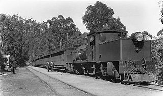
The Mundaring Weir Branch Railway was constructed from Mundaring, Western Australia to the site of the Mundaring Weir, and opened on 1 June 1898.

<span class="mw-page-title-main">Flinders Bay Branch Railway</span> Former Busselton to Flinders Bay railway line

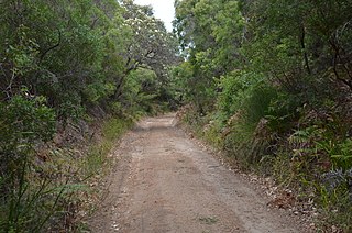
The Flinders Bay Branch Railway, also known as the Boyanup to Flinders Bay Section ran between Boyanup and Flinders Bay, in South Western Western Australia. The section from Flinders Bay to Busselton has now been converted into a rail trail for bushwalkers and cyclists, called the Wadandi Trail.

<span class="mw-page-title-main">Shire of Derby–West Kimberley</span> Local government area in Western Australia

The Shire of Derby–West Kimberley is one of four local government areas in the Kimberley region of northern Western Australia, covering an area of 104,080 square kilometres (40,186 sq mi), most of which is sparsely populated. The Shire's population as at the 2016 Census was almost 8,000, with most residing in the major towns of Derby, which is also the Shire's seat of government, and Fitzroy Crossing. There are also around 70 Aboriginal communities within the Shire.

Roelands is a town in the South West region of Western Australia on the South Western Highway, between Brunswick Junction and Bunbury. At the 2011 census, Roelands had a population of 620.

<span class="mw-page-title-main">South Western Railway, Western Australia</span> Main railway route between Perth and Bunbury in Western Australia

The South Western Railway, also known as the South West Main Line, is the main railway route between Perth and Bunbury in Western Australia.

<span class="mw-page-title-main">Trayning, Western Australia</span> Town in Western Australia

Trayning is a town in the north-eastern Wheatbelt region of Western Australia, 236 kilometres (147 mi) east of the state capital, Perth, on the Nungarin–Wyalkatchem Road. At the 2006 census, Trayning had a population of 122.

<span class="mw-page-title-main">Timber railway lines of Western Australia</span> Railway lines utilised by timber industry in Western Australia

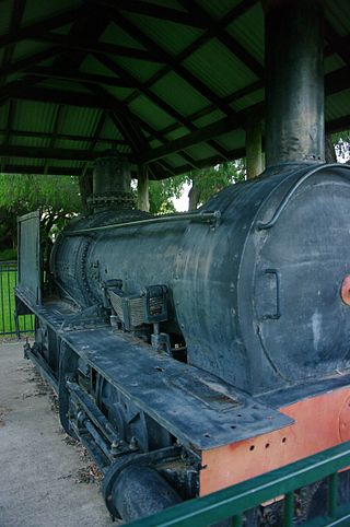
The network of railway lines in Western Australia associated with the timber and firewood industries is as old as the mainline railway system of the former Western Australian Government Railways system.

<span class="mw-page-title-main">Witchcliffe, Western Australia</span> Town in Western Australia

Witchcliffe is a small town in the South West region of Western Australia, located a few kilometres south of Margaret River on the Bussell Highway. The name originates from a cave in the area, Witchcliffe cave, that was recorded by a surveyor in 1900. It is believed the name was given by the Bussell family whose property, Wallcliffe, was established in the area in the 1850s.

<span class="mw-page-title-main">Wilga, Western Australia</span> Town in Western Australia

Wilga is a small town located between Donnybrook and Boyup Brook in the South West region of Western Australia.

<span class="mw-page-title-main">W.A. Timber Company</span> Syndicate of Victorian investors

W.A. Timber Company was a syndicate of Victorian investors granted a timber concession of 181,500 acres on Geographe Bay in the south west of Western Australia in 1870.

Mornington, also known as Mornington Mills, is the site of former timber saw mills and a community on the Darling Range in Western Australia. It was part of the operations of Millars Karri and Jarrah Forests Limited. At the 2021 census, the area had a population of 42.

<span class="mw-page-title-main">Neil McNeil (businessman)</span> Australian railway contractor and businessman

Neil McNeil was a prominent Australian businessman who was significant in the development of railways across Australia along with Western Australia's timber industry.

<span class="mw-page-title-main">Northcliffe Branch railway</span> Branch railway in South West region of Western Australia

The Northcliffe Branch, also known as the Northcliffe Section or Picton to Northcliffe Line, is the railway route between Picton and Northcliffe in Western Australia.

References

  1. Australian Bureau of Statistics (28 June 2022). "Wokalup (Suburb and Locality)". Australian Census 2021 QuickStats. Retrieved 28 June 2022.  OOjs UI icon edit-ltr-progressive.svg
  2. Australian Bureau of Statistics (25 October 2007). "Wokalup (State Suburb)". 2006 Census QuickStats. Retrieved 25 July 2011.
  3. Map 5, page 266 of Gunzburg, Adrian; Austin, Jeff; Rail Heritage WA; Gunzburg, Adrian; Austin, Jeff (2008), Rails through the bush : timber and firewood tramways and railway contractors of Western Australia (2nd ed.), Rail Heritage WA, ISBN   978-0-9803922-2-7
  4. Shire of Harvey. "Local Towns - Wokalup". Archived from the original on 20 July 2011. Retrieved 5 October 2006.
  5. "History of country town names – W". Western Australian Land Information Authority. Retrieved 17 January 2007.