Bunbury is a coastal city in the Australian state of Western Australia, approximately 175 kilometres (109 mi) south of the state capital, Perth. It is the state's third most populous city after Perth and Mandurah, with a population of approximately 75,000.

Sir James Mitchell, was an Australian politician. He served as premier of Western Australia from 1919 to 1924 and from 1930 to 1933, as leader of the Nationalist Party. He then held viceregal office from 1933 to 1951, as acting governor from 1933 to 1948 and governor of Western Australia from 1948 until his death in 1951.

Wagin is a town and shire in the Wheatbelt region of Western Australia, approximately 225 km (139.81 mi) south-east of Perth on the Great Southern Highway between Narrogin and Katanning. It is also on State Route 107. The main industries are wheat and sheep farming.

Narrogin is a large town in the Wheatbelt region of Western Australia, 192 kilometres (119 mi) southeast of Perth on the Great Southern Highway between Pingelly and Wagin. In the age of steam engines, Narrogin was one of the largest railway operation hubs in the southern part of Western Australia.

Cue is a small town in the Mid West region of Western Australia, located 620 km north-east of Perth. At the 2016 census, Cue had a population of 178. Cue is administered through the Cue Shire Council, which has its chambers in the historic Gentlemans Club building. The current president is Ross Pigdon. The Cue Parliament is held twice yearly in May and November.

Boyanup is a town on the South Western Highway in the South West agricultural region, 195 km south of Perth and 18 km south-east of Bunbury, Western Australia. The town is located on the Preston River.

Brunswick Junction is a town in the South West of Western Australia, situated along the South Western Highway between Harvey and Bunbury. It had a population of 772 people at the 2016 census, down from 797 at the 2006 census.

Goomalling is a townsite in the Wheatbelt region of Western Australia, 45 kilometres north-north-east of Northam, Western Australia.

Tammin is a town in the central agricultural region of Western Australia, 184 kilometres (114 mi) east of Perth and midway between the towns of Cunderdin and Kellerberrin on the Great Eastern Highway.

Kellerberrin is a town in the Wheatbelt region of Western Australia, 205 kilometres (127 mi) east of Perth on the Great Eastern Highway. The town serves as a stop on the Prospector and MerredinLink rural train services. It is also located on the Golden Pipeline Heritage Trail.

Serpentine is a town located 55 kilometres (34 mi) south-southeast of Perth, the capital of Western Australia, and 7 km south of Mundijong.

Beverley is a town in the Wheatbelt region of Western Australia, 133 kilometres (83 mi) south-east of the state capital, Perth, between York and Brookton on the Great Southern Highway. It is on the Great Southern railway line.

Williams is a town located in the Wheatbelt region of Western Australia, 161 kilometres (100 mi) south-southeast of the state capital, Perth along Albany Highway and 32 kilometres (20 mi) west of Narrogin. The Williams River passes through the town. At the 2016 census, Williams had a population of 411.
The Department of Primary Industries and Regional Development (DPIRD) is a Western Australian government department responsible for regulating and advancing agricultural and food industries, fisheries and regional development within the state. It was formed by an amalgamation of the Department of Agriculture and Food, Department of Fisheries and Department of Regional Development in 2017.

Broomehill is a town on the Great Southern Highway between Katanning and Albany, in the Great Southern region of Western Australia. Its local government area is the Shire of Broomehill-Tambellup.

Pingelly is a town and shire located in the Wheatbelt region of Western Australia, 158 kilometres (98 mi) from Perth via the Brookton Highway and Great Southern Highway. The town is also located on the Great Southern railway line.
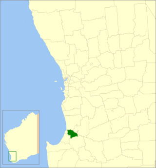
The Shire of Dardanup is a local government area in the South West region of Western Australia, immediately to the east and southeast of the City of Bunbury and about 180 kilometres (112 mi) south of the state capital, Perth. The Shire covers an area of 526.6 square kilometres (203.3 sq mi), and its seat of government is in Eaton in Bunbury's eastern suburbs.
Burbanks is an abandoned town in Western Australia located between Coolgardie and Londonderry in the Goldfields-Esperance region of Western Australia.
Byrnestown is a rural locality in the North Burnett Region, Queensland, Australia. In the 2016 census, Byrnestown had a population of 34 people.
Coondle is a small acre farming estate in the Shire of Toodyay in Western Australia. It started as an estate developed under the provisions of the Agricultural Lands Purchase Act (1896) near what was then known as Newcastle.


