Wood Mountain Regional Park

Last updated

Wood Mountain Regional Park
Canada Saskatchewan relief location map.jpg
Red pog.svg
Location of Wood Mountain Regional Park within Saskatchewan
Canada relief map 2.svg
Red pog.svg
Wood Mountain Regional Park (Canada)
Location RM of Old Post No. 43, Flag of Saskatchewan.svg  Saskatchewan
Nearest city Wood Mountain
Coordinates 49°19′13″N106°22′57″W / 49.3202°N 106.3825°W / 49.3202; -106.3825
Governing bodySaskatchewan Regional Parks Association

Wood Mountain Regional Park [1] is a conservation and recreation area in its natural state set aside as a regional park in south-western region of the Canadian province of Saskatchewan. The park is set in the semi-arid Palliser's Triangle in an upland area called Wood Mountain Hills. [2] It is in the Rural Municipality of Old Post No. 43, 8 kilometres (5.0 mi) south of the village of Wood Mountain along Highway 18.

Contents

Adjacent to the southern boundary of Wood Mountain Regional Park is Wood Mountain Creek [3] and Wood Mountain Post Provincial Park. [4] Immediately to the west is Wood Mountain Indian reserve and to the east is the Wood Mountain Game Preserve ( 49°18′00″N106°17′02″W / 49.3001°N 106.2839°W / 49.3001; -106.2839 ).

Amenities and attractions within the park include the Rodeo Ranch Museum, Wood Mountain Stampede, Sitting Bull Monument, ball diamonds, campsites, concessions, swimming pool, and hiking and bicycling trails. This is a local park administered by local funding. [5] [6]

History

In 1874, the Boundary Commission, which was charged with surveying the Canada–United States border, set up a depot on Wood Mountain Creek at the current location of Wood Mountain Regional Park. Later that year, the North-West Mounted Police (NWMP) on their March West to deal with the Cypress Hills Massacre, bought the depot and used it to establish relations with local First Nations, patrol the border with the United States, and to police whisky traders, horse thieves, and cattle rustlers.

In 1876, Chief Sitting Bull led his 5,000-strong Lakota Sioux tribe away from the Little Bighorn River into the Wood Mountain Hills in Canada after defeating Custer at the Battle of the Little Bighorn. The Canadian government was concerned that the Sioux would cause problems, and charged James Walsh of the NWMP with maintaining control of what amounted to Canada's first attempted peace keeping mission. Walsh succeeded, as he and Sitting Bull became close friends over the years. In the neighbouring provincial park, there are two reconstructed buildings with artefacts that tell the story of Walsh and Sitting Bull. Chief Sitting Bull and some of his people returned to the United States after five years while most stayed in the Wood Mountain area. In 1910, they were given their own Indian reserve and many of their descendants remain in the area to this day.

The North-West Mounted Police closed Wood Mountain Post in 1883. Then, with the out-break of the North-West Rebellion, it was re-opened in 1885. Two years later, the dilapidated buildings were abandoned and new buildings were constructed 300 metres (980 ft) to the south-east, across Wood Mountain Creek (which is a tributary of Wood River via Lynthorpe Creek) and in the current Wood Mountain Post Provincial Park. The post operated at that location until it was permanently closed in 1918. [7]

Attractions and amenities

Wood Mountain Regional Park is set in rolling hills and ranchland. There are several trails throughout the park, including one that leads to the provincial park. There is a heated swimming pool, a campground, museum, Bible camp, [8] and Canada's longest running rodeo. [9] [10] A monument to Chief Sitting Bull sits atop a hill overlooking the regional park, behind the museum.

Rodeo Ranch Museum

The Rodeo Ranch Museum features exhibits about the cowboys and ranchers who settled the area in the 1880s. Exhibits include photographs, pioneer, rodeo and Western artefacts. The information centre for the East Block of Grasslands National Park is located in the museum.

Wood Mountain Stampede

In 1890, the Wood Mountain Stampede was established by the North-West Mounted Police to promote sports and to celebrate the July 1 Dominion Day holiday. It became an annual event held every second weekend in July and is Canada's longest-running annual rodeo. [11]

See also

Related Research Articles

<span class="mw-page-title-main">Willmore Wilderness Park</span> Provincial park of Alberta, Canada

Willmore Wilderness Park, in Alberta, Canada, is a 4,600-square-kilometre (1,800 sq mi) wilderness area adjacent to Jasper National Park. It is lesser known and less visited than Jasper National Park. There are no public roads, bridges or buildings. There are, however, several ranger cabins in the park that are available as a courtesy to visitors.

<span class="mw-page-title-main">Grasslands National Park</span> National park in Saskatchewan, Canada

Grasslands National Park is a Canadian national park located near the village of Val Marie, Saskatchewan, and one of 44 national parks and park reserves in Canada's national park system. This national park is north of the U.S. state of Montana and lies adjacent to the international boundary. It consists of two separate parcels, the East Block and West Block.

<span class="mw-page-title-main">James Morrow Walsh</span>

James Morrow Walsh was a North-West Mounted Police (NWMP) officer and the first commissioner of Yukon.

<span class="mw-page-title-main">Shaunavon, Saskatchewan</span> Town in Saskatchewan, Canada

Shaunavon is a town in southwest Saskatchewan. At the junction of Highways 37 and 13, it is 110 kilometres from Swift Current, 163 kilometres from the Alberta border, and 74 kilometres from the Montana border. Shaunavon was established in 1913 along the Canadian Pacific Railway line.

<span class="mw-page-title-main">Arcola, Saskatchewan</span> Town in Saskatchewan, Canada

Arcola is a town in south-east Saskatchewan, Canada, approximately 60 kilometres (37 mi) north and 40 kilometres (25 mi) east of Estevan. Highway 13, Highway 604, and Arcola Airport provide access to the community.

Rockglen is a town in the Burning Hills of the Wood Mountain Uplands, in Saskatchewan, Canada. It offers various amenities including a school, community hall, public library and five parks, as well a local service industry. The municipal office of the Rural Municipality of Poplar Valley No. 12 lies within the boundaries of Rockglen, and Rockglen businesses are supported primarily by agriculture. In the Burning Hills agriculture consists of dry land farming and cattle. Rockglen is located along Highway 2 south of Assiniboia, Highway 18 west of Coronach, and Highways 2 and 18 north of Port Poplar River. Fife Lake is 9.3 kilometres (5.8 mi) to the east.

<span class="mw-page-title-main">Saskatchewan Highway 13</span> Highway in Saskatchewan

Highway 13 is a highway in the Canadian province of Saskatchewan. It runs from the Alberta border until it transitions into Highway 2 at the Manitoba border near Antler. Highway 13 is about 676 km (420 mi.) long. Highway 13 passes through Shaunavon, Assiniboia, Weyburn, Redvers and Carlyle. It is also referred to as the Red Coat Trail, as much of its length follows the route of the original historic path. A majority of the route between Wauchope and Govenlock going through the Palliser's Triangle is also referred to as the Ghost Town Trail.

<span class="mw-page-title-main">Saskatchewan Highway 58</span> Provincial highway in Saskatchewan, Canada

Highway 58 is a provincial highway in the Canadian province of Saskatchewan that handles approximately 100 vehicles per day. The highway runs from Highway 18 about 3 kilometres (1.9 mi) west of Fir Mountain north until Highway 1 / Highway 19 at Chaplin in the south-central region of the province. There are multiplexes of 1.6 kilometres (1.0 mi) with Highway 13, 300 metres (980 ft) with Highway 43, and 4.9 kilometres (3.0 mi) with Highway 363. The section from its southern terminus north to Shamrock is paved while north of Shamrock to Chaplin is gravel. The highway is about 132 kilometres (82 mi) long.

<span class="mw-page-title-main">Carlyle, Saskatchewan</span> Town in Saskatchewan, Canada

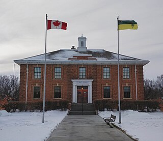
Carlyle is a town in the province of Saskatchewan, Canada. Carlyle is the largest town servicing the far south-eastern corner of Saskatchewan and as a result, has become the economic and services centre of the region. Estevan and Weyburn are the closest cities and both are a little over 100 kilometres away. Regina, the provincial capital, lies 200 km to the north-west.

<span class="mw-page-title-main">Red Coat Trail</span> Highway in Alberta, Saskatchewan, Manitoba

The Red Coat Trail is a 1,300-kilometre (810 mi) route that approximates the path taken in 1874 by the North-West Mounted Police in their March West from Fort Dufferin to Fort Whoop-Up.

<span class="mw-page-title-main">Broadview, Saskatchewan</span> Town in Saskatchewan, Canada

Broadview is a community in Saskatchewan along Highway 1, the Trans-Canada Highway, 155 kilometres (96 mi) east of Regina. The local economy is based mainly on agriculture. It is also the administrative headquarters of the Rural Municipality of Elcapo No. 154

<span class="mw-page-title-main">Wood Mountain, Saskatchewan</span> Community in Saskatchewan, Canada

Wood Mountain is a village in the Canadian province of Saskatchewan within the Rural Municipality of Old Post No. 43 and Census Division No. 3. Its name is derived from the Red River Métis words "montagne de bois", due to the abundance of poplar trees in the otherwise barren region. Highway 18 and Highway 358 intersect south of the community.

<span class="mw-page-title-main">Rural Municipality of Old Post No. 43</span> Rural municipality in Saskatchewan, Canada

The Rural Municipality of Old Post No. 43 is a rural municipality (RM) in the Canadian province of Saskatchewan within Census Division No. 3 and SARM Division No. 2. It is located in the southern portion of the province adjacent to the United States border, neighbouring Valley County and Daniels County in Montana.

<span class="mw-page-title-main">Philip Primrose</span> Canadian police officer and Lieutenant Governor of Alberta, 1864–1937

Philip Carteret Hill Primrose was a Canadian police officer and the fifth Lieutenant Governor of Alberta.

<span class="mw-page-title-main">Jean-Louis Légaré</span>

Jean-Louis Légaré was a French-Canadian trader and one of the founding members of Willow Bunch, Saskatchewan.

<span class="mw-page-title-main">Carry the Kettle Nakoda Nation</span> Native American tribal organization in Saskatchewan

Carry the Kettle Nakoda Nation is a Nakota (Assiniboine) First Nation in Canada located about 80 km (50 mi) east of Regina, Saskatchewan and 13 km (8.1 mi) south of Sintaluta. The reservation is in Treaty 4 territory.

<span class="mw-page-title-main">Thomas Edmonds Wilson</span> Canadian guide

Thomas Edmonds Wilson was a Canadian outfitter and guide.

Wood Mountain Post Provincial Park is a 5.48-hectare historical provincial park in the Canadian province of Saskatchewan. The site was designated as an historic site in the 1960s and became a provincial park in 1986. Originally, it was the location of a North-West Mounted Police (NWMP) post that operated from 1887 to 1918. The post was established to develop relations with local Indians, patrol the Canada–United States border, and to perform general policing duties.

Wood River is a river in the Canadian province of Saskatchewan. It has its source in the Wood Mountain Hills of south-western Saskatchewan and flows in a north-easterly direction to its mouth at Old Wives Lake. Old Wives Lake is a salt water lake with no outflow. As a result, the drainage basin of Wood River is an endorheic one. Along the course of the river, there are several parks, historical sites, and small towns.

Wood Mountain Hills are a hilly plateau in the Canadian province of Saskatchewan. The hills are located in the southern part of the province and are part of the Missouri Coteau, which is part of the Laurentian Divide between the watersheds of the Hudson Bay drainage basin of the Arctic Ocean and the Gulf of Mexico of the Atlantic Ocean. The hills are in a semi-arid region known as Palliser's Triangle in the Great Plains ecoregion of North America.

References

  1. "Wood Mountain Regional Park". Canadian Geographical Names Database. Government of Canada. Retrieved 5 October 2022.
  2. "Wood Mountain Plateau". The Encyclopedia of Saskatchewan. University of Regina. Retrieved 25 September 2022.
  3. "Wood Mountain Creek". Canadian Geographical Names Database. Government of Canada. Retrieved 5 October 2022.
  4. "Wood Mountain Post Provincial Historic Park". Tourism Saskatchewan. Government of Saskatchewan. Retrieved 5 October 2022.
  5. "Wood Mountain Regional Park". Tourism Saskatchewan. Government of Saskatchewan. Retrieved 6 October 2022.
  6. Saskatchewan Regional Parks Association. "Wood Mountain Regional Park". Archived from the original on 28 September 2007. Retrieved 27 April 2007.
  7. "Wood Mountain Post Provincial Park". Canada's Historic Places. Parks Canada. Retrieved 5 October 2022.
  8. "Camp Woodboia". Saskatchewan Camps Association. Retrieved 6 October 2022.
  9. "Attractions". Wood Mountain Park. Wood Mountain Regional Park. Retrieved 5 October 2022.
  10. "Wood Mountain". Regional Parks of Saskatchewan. Saskatchewan Regional Parks. Retrieved 5 October 2022.
  11. "Wood Mountain Sports and Stampede". Wood Mountain Rodeo. Retrieved 6 October 2022.