Yellowtail Dam

Last updated
Yellowtail Dam
Photo of Yellowtail Dam, Montana.jpeg
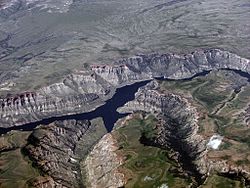
View of the dam face looking upstream
USA Montana relief location map.jpg
Red pog.svg
Location of the Yellowtail Dam in Montana
CountryUnited States
Location Big Horn County, Montana
Coordinates 45°18′24″N107°57′29″W / 45.30667°N 107.95806°W / 45.30667; -107.95806
Construction began1961
Opening date1967
Construction cost$110 million
Owner(s) U.S. Bureau of Reclamation
Dam and spillways
Type of dam Concrete arch-gravity
Impounds Bighorn River
Height525 ft (160 m)
Length1,480 ft (450 m)
Width (crest)22 ft (6.7 m)
Width (base)147 ft (45 m)
Dam volume1,545,664 cu yd (1,181,745 m3)
Spillways 1 main + outlet works
Spillway typeConcrete tunnel, 2x radial gates
Spillway capacity92,000 cu ft/s (2,600 m3/s)
Reservoir
Creates Bighorn Lake
Total capacity1,381,189  acre⋅ft (1.703672 km3)
Catchment area 19,600 sq mi (51,000 km2)
Surface area17,300 acres (7,000 ha)
Power Station
Hydraulic head 495 ft (151 m)
Turbines 4x 62.5MW Francis
Installed capacity 250 MW
Annual generation 510,564,280 KWh

Yellowtail Dam is a dam across the Bighorn River in south central Montana in the United States. The mid-1960s era concrete arch dam serves to regulate the flow of the Bighorn for irrigation purposes and to generate hydroelectric power. The dam and its reservoir, Bighorn Lake, are owned by the U.S. Bureau of Reclamation.

Contents

The project was the result of negotiations between the federal government and the Crow Nation, the tribe of Native Americans that lived on the surrounding Crow Indian Reservation, and was originally envisioned as a shared facility that would provide profits for both sides. Eventually, the land was sold to Reclamation, although much of the reservoir, which extends 72 miles (116 km) upstream into Wyoming, lies in the reservation. The dam was authorized in 1944 and groundbreaking was in 1961; it was completed in 1967 after six years of construction. Today aside from its original purposes the dam serves for recreation both above and below the structure. Regulation of the Bighorn provided by the Yellowtail Dam has transformed the lower river into one of Montana's premier trout streams. However, there has been significant controversy surrounding the allocation of water in the reservoir between Montana and Wyoming, and the ecological damage wrought on 184 miles (296 km) of river both above and below the dam.

History

Planning

In the early 20th century, the population of the Yellowstone River valley of southern Montana, of which the Bighorn River is the largest tributary, was growing rapidly and so was the acreage of irrigated land – however, the system was vulnerable to floods and droughts. In 1905, the federal government conducted the first feasibility studies for a dam on a stretch of the Bighorn within the Crow Indian Reservation, some 45 miles (72 km) southeast of Billings, Montana. The leaders of the Crow Nation, which owned the land, agreed to building a dam there because electricity generated there would provide income for the tribe. [1]

Construction of the Yellowtail Dam was authorized by the Flood Control Act on December 22, 1944 as part of the Pick-Sloan Plan, a water management scheme covering the entire upper Missouri River Basin in the north-central United States. [2] [3] Three proposals were then made by the Reclamation Service, the predecessor of the present-day Bureau of Reclamation, during the first half of the century. The first idea called for the building of a 480-foot (150 m) arch gravity dam at the present-day site. The second suggested constructing a pair of smaller dams on the river about 70 miles (110 km) apart. Plans for the current dam were finalized in the 1950s, as a high dam would provide a greater hydraulic head, allowing water to be diverted into canals at higher elevations to serve farms both within and downstream of the Crow lands. [4]

The dam is named after Robert Yellowtail, chairman of the tribe during the 1940s. Yellowtail was one of the main opponents of the dam and also protested when the tribe decided to sell the dam site to the federal government. For a while, the Crow Nation considered leasing the land to the government for fifty years at a rate of $1,000,000 per year. The arguments deeply divided the tribe, causing them to separate into two factions, the Mountain Crows, which backed Yellowtail and opposed the dam, and the River Crows, which supported the dam. Eventually, the land was sold for $2.5 million, and controversy continued for years afterward. [5] [6]

Construction

Boise, Idaho based Morrison-Knudsen, at the time the largest heavy contractor in the world, landed the contract to build the dam. Morrison-Knudsen had previously built the Hoover and Grand Coulee Dams. [7] Official groundbreaking for the Yellowtail Dam was in 1961 and the construction of a diversion tunnel was begun soon afterwards. The concrete-lined conduit ultimately extended over 2,000 feet (610 m) and had a diameter of 32 feet (9.8 m). A cofferdam was then raised to divert the Bighorn out of the dam site into the tunnel. [4] The first concrete pour was on March 16, 1963, and the diversion tunnel was closed in November 1965, allowing the river to begin filling Bighorn Lake. In the same year, the Yellowtail Afterbay Dam, serving to regulate releases from the main dam was completed 2.2 miles (3.5 km) downstream of Yellowtail Dam. [8] The Yellowtail Dam was topped out in December 1967 after six years of work. [9] Surprisingly, for such a huge structure, only one death occurred during the entire construction process. [4]

Characteristics

Dam and reservoir

The Yellowtail Dam is a concrete thin-arch dam 525 feet (160 m) high and 1,480 feet (450 m) long, containing 1,545,664 cubic yards (1,181,745 m3) of material. The crest of the dam lies 3,660 feet (1,120 m) above sea level. [10] As the crow flies, the dam is 45 miles (72 km) southeast of Billings and 23 miles (37 km) north of the Montana-Wyoming border. The dam and reservoir lie in Bighorn Canyon in the northwestern portion of the Bighorn Range where the Bighorn River cuts through it, 112 miles (180 km) above the Bighorn's junction with the Yellowstone at Custer, Montana.

Bighorn Lake is the reservoir formed behind the dam, and has a capacity of 1,381,189 acre-feet (1.703672×10⁹ m3) of water. [11] At normal storage the reservoir covers 17,300 acres (70 km2), extending over 70 miles (110 km) upstream. [9] The lake is long and narrow, except for the uppermost section near Kane, Wyoming where it broadens to about 2 miles (3.2 km). Aside from the Bighorn River the reservoir is also fed by the Shoshone River, Porcupine Creek, Dry Head Creek, Big Bull Elk Creek, Black Canyon Creek, and smaller tributaries. [12]

Power generation

The dam's hydroelectric plant is located at the base and has a capacity of 250 MW. The plant has four Francis turbines rated at 87,500 horsepower, each capable of driving a 62,500 KW generator. The hydraulic head is roughly 495 feet (151 m) at normal reservoir elevation. Operations of the facility began in 1966, one year before the completion of the dam. The power station is used based on peaking power demand and thus releases can vary drastically over the course of a day. The Yellowtail Afterbay dam, built for the purpose of regulating the fluctuating discharge from the power station, lies 2.2 miles (3.5 km) below the main dam and can store 3,140 acre-feet (3,870,000 m3) of water. This dam generally releases a constant flow of 2,500 to 3,000 cubic feet per second (71 to 85 m3/s) into the Bighorn. [8] [13]

Spillway

To pass flood waters the Yellowtail Dam is equipped with a tunnel spillway on the left side, capable of handling 92,000 cubic feet per second (2,600 m3/s). The spillway is controlled by a pair of radial gates measuring 25 feet (7.6 m) high and 64.4 feet (19.6 m) long. The dam also has a set of outlet works that can discharge up to 2,500 cubic feet per second (71 m3/s). [11]

In 1967, heavy snowmelt in the Bighorn River basin caused the reservoir to rise to record levels. Reclamation opened the spillway of the dam for twenty consecutive days in June and July of that year. However, the design of the spillway tunnel was flawed, causing severe cavitation of the concrete, leading to the formation of a hole the size of an eighteen-wheeler in the concrete lining. The resulting repairs and retrofits to the spillway were the vital predecessor to the repair work to dams such as Hoover, Glen Canyon and Flaming Gorge that would follow severe floods in 1983 in the Colorado River basin. [14] [15]

Recreation

Bighorn Lake is the reservoir formed by Yellowtail Dam and is a popular boating area. Bighorn Lake WY & MT - SW part.jpg
Bighorn Lake is the reservoir formed by Yellowtail Dam and is a popular boating area.

Although unplanned for, by regulating the flow of the Bighorn River and releasing cooler water from the bottom of Bighorn Lake, the Yellowtail Dam has created one of the finest wild trout fisheries in the United States in the slightly more than 110 miles (180 km) of river downstream. [4] [16] However, the dam has significantly changed the native riverine habitat downstream as well – cutting off the supply of sediments, which once created islands and sandbars in the Bighorn's winding lower course. Nevertheless, the combination of cold, fast-flowing water and abundant nutrients creates an ideal trout habitat; the average length of a trout caught in the lower Bighorn is 14 inches (36 cm), while the record was a 16-pound (7.3 kg) rainbow trout 29 inches (74 cm) long. [17]

In recent years there has been controversy between Montana and Wyoming over whether more water should be kept in Bighorn Lake for boating and water-skiing uses (almost two-thirds of the surface area of Bighorn Lake is in Wyoming), or released from the dam to maintain the trout fishery downstream. Because of a long and ongoing drought in the western United States, Reclamation has reduced the amount of water below the Yellowtail Dam from 2,500 cubic feet per second (71 m3/s) to 2,000 cubic feet per second (57 m3/s). The lower flows have led to unhealthy trout populations in turn causing the fishing industry on the lower Bighorn to decline by over 40 percent. However, low water levels in the lake have caused recreational usage in Wyoming to drop more than 60%. In an attempt to reduce tensions between the two states Reclamation has agreed to keep the lake at a higher level while maintaining at least 1,500 cubic feet per second (42 m3/s) of flow below the dam. [2] [16] [18]

See also

Related Research Articles

<span class="mw-page-title-main">Bighorn Canyon National Recreation Area</span> National recreation area in the United States

Bighorn Canyon National Recreation Area is a national recreation area established by an act of Congress on October 15, 1966, following the construction of the Yellowtail Dam by the Bureau of Reclamation. It is one of over 420 sites managed by the U.S. National Park Service. The recreation area spans 120,296.22 acres, straddling the border between Wyoming and Montana. It is divided into two distinct areas, the North District accessed via Fort Smith, Montana and the South District accessed through Lovell, Wyoming. There is no thru road inside the recreation area connecting the two districts. The Yellowtail Dam is located in the North District. It is named after the famous Crow leader Robert Yellowtail, harnesses the waters of the Bighorn River by turning that variable watercourse into Bighorn Lake. The lake extends 71 miles (114 km) through Wyoming and Montana, 55 miles (89 km) of which lie within the national recreation area. The lake provides recreational boating, fishing, water skiing, kayaking, and birding opportunities to visitors. About one third of the park unit is located on the Crow Indian Reservation. Nearly one-quarter of the Pryor Mountains Wild Horse Range lies within the Bighorn Canyon National Recreation Area.

<span class="mw-page-title-main">Bighorn River</span> River in Wyoming and Montana, United States

The Bighorn River is a tributary of the Yellowstone, approximately 461 miles (742 km) long, in the states of Wyoming and Montana in the western United States. The river was named in 1805 by fur trader François Larocque for the bighorn sheep he saw along its banks as he explored the Yellowstone.

<span class="mw-page-title-main">Pick–Sloan Missouri Basin Program</span>

The Pick–Sloan Missouri Basin Program, formerly called the Missouri River Basin Project, was initially authorized by the Flood Control Act of 1944, which approved the plan for the conservation, control, and use of water resources in the Missouri River Basin.

<span class="mw-page-title-main">Big Bend Dam</span> Dam on the Missouri River in South Dakota, US

Big Bend Dam is a major embankment rolled-earth dam on the Missouri River in Central South Dakota, United States, creating Lake Sharpe. The dam was constructed by the U.S. Army Corps of Engineers as part of the Pick-Sloan Plan for Missouri watershed development authorized by the Flood Control Act of 1944. Construction began in 1959 and the embankment was completed in July 1963. Power generation began at the facility in 1964 and the entire complex was completed in 1966 at a total cost of $107 million. The hydroelectric plant generates 493,300 kilowatts of electricity at maximum capacity, with an annual production of 969 million kilowatt hours, and meets peak-hour demand for power within the Missouri River Basin.

<span class="mw-page-title-main">Oahe Dam</span> Dam in Hughes/Stanley counties, South Dakota

The Oahe Dam is a large earthen dam on the Missouri River, just north of Pierre, South Dakota, United States. The dam creates Lake Oahe, the fourth-largest man-made reservoir in the United States. The reservoir stretches 231 miles (372 km) up the course of the Missouri to Bismarck, North Dakota. The dam's power plant provides electricity for much of the north-central United States. It is named for the Oahe Indian Mission established among the Lakota Sioux in 1874.

<span class="mw-page-title-main">Table Rock Lake</span> Man-made lake in Missouri and Arkansas, United States

Table Rock Lake is an artificial lake or reservoir in the Ozarks of southwestern Missouri and northwestern Arkansas in the United States. Designed, built and operated by the U.S. Army Corps of Engineers, the lake is impounded by Table Rock Dam, which was constructed from 1954 to 1958 on the White River.

<span class="mw-page-title-main">Flaming Gorge Dam</span> Dam on the Green River in Utah, United States

Flaming Gorge Dam is a concrete thin-arch dam on the Green River, a major tributary of the Colorado River, in northern Utah in the United States. Flaming Gorge Dam forms the Flaming Gorge Reservoir, which extends 91 miles (146 km) into southern Wyoming, submerging four distinct gorges of the Green River. The dam is a major component of the Colorado River Storage Project, which stores and distributes upper Colorado River Basin water.

<span class="mw-page-title-main">Shoshone Project</span>

The Shoshone Project is an irrigation project in the U.S. state of Wyoming. The project provides irrigation for approximately 107,000 acres (430 km2) of crops in the Big Horn Basin, fulfilling the vision of local resident and developer Buffalo Bill Cody, who hoped to make the semi-arid basin into agricultural land. Buffalo Bill Dam on the Shoshone River impounds water for the project in Buffalo Bill Reservoir. In addition to its role in irrigation, the project provides flood control on the Shoshone and generates power, using the 350-foot (110 m) height of Buffalo Bill Dam, once a world record, and the considerable fall of the river through Shoshone Canyon to generate hydroelectric power. Chief crops in the Big Horn Basin are sugar beets, alfalfa, barley, oats, corn and beans.

<span class="mw-page-title-main">Navajo Dam</span> Dam in San Juan and Rio Arriba Counties, New Mexico

Navajo Dam is a dam on the San Juan River, a tributary of the Colorado River, in northwestern New Mexico in the United States. The 402-foot (123 m) high earthen dam is situated in the foothills of the San Juan Mountains about 44 miles (71 km) upstream and east of Farmington, New Mexico. It was built by the U.S. Bureau of Reclamation (Reclamation) in the 1960s to provide flood control, irrigation, domestic and industrial water supply, and storage for droughts. A small hydroelectric power plant was added in the 1980s.

<span class="mw-page-title-main">Canyon Ferry Dam</span> Dam in Montana, USA

Canyon Ferry Dam is a concrete gravity dam in a narrow valley of the Missouri River, United States, where the Big Belt Mountains and the Spokane Hills merge, approximately 68 miles (109 km) downstream from the confluence of the Gallatin, Madison, and Jefferson rivers, and about 20 miles (32 km) east of the city of Helena, Montana. The dam is for flood control, irrigation, recreation and hydroelectric power. The building of the dam created a reservoir known as Canyon Ferry Lake.

<span class="mw-page-title-main">Rio Grande Project</span>

The Rio Grande Project is a United States Bureau of Reclamation irrigation, hydroelectricity, flood control, and interbasin water transfer project serving the upper Rio Grande basin in the southwestern United States. The project irrigates 193,000 acres (780 km2) along the river in the states of New Mexico and Texas. Approximately 60 percent of this land is in New Mexico. Some water is also allotted to Mexico to irrigate some 25,000 acres (100 km2) on the south side of the river. The project was authorized in 1905, but its final features were not implemented until the early 1950s.

<span class="mw-page-title-main">Spring Creek Dam</span> Dam in Shasta County, California

Spring Creek Debris Dam is an earthfill dam on Spring Creek, a tributary of the Sacramento River, in Shasta County in the U.S. state of California. Completed in 1963, the dam, maintained by the U.S. Bureau of Reclamation, serves primarily to collect severe acid mine drainage stemming from the Iron Mountain Mine. The dam forms the Spring Creek Reservoir, less than 1 mile (1.6 km) long. Spring Creek and South Fork Spring Creek flow into the reservoir from a 16-square-mile (41 km2) watershed. The dam is directly upstream from the city of Keswick, California and the Keswick Reservoir. The operation is part of the Trinity River Division of the Central Valley Project.

<span class="mw-page-title-main">Risks to the Glen Canyon Dam</span> Aspect of dam construction

Glen Canyon Dam, a concrete arch dam on the Colorado River in the American state of Arizona, is viewed as carrying a large amount of risk, most notably due to siltation. The Colorado and San Juan rivers deposit large volumes of silt into Lake Powell, slowly decreasing its capacity. The sediment will eventually build up against the dam and could affect its safe operation and lead to its failure.

<span class="mw-page-title-main">Caballo Dam</span> Dam on the Rio Grande in New Mexico, United States

Caballo Dam is an earthen dam on the Rio Grande about 15 miles (24 km) downstream from Truth or Consequences, New Mexico, United States. In conjunction with Elephant Butte Dam, which lies about 25 miles (40 km) upstream, it regulates the discharge of the river in the lower Rio Grande Valley of New Mexico. Caballo serves as an afterbay for the Elephant Butte Reservoir, i.e. it stores water released from Elephant Butte for hydroelectricity generation purposes and discharges it in the dry season to provide for irrigation agriculture downstream. The dam is an important part of the Rio Grande Project. A secondary purpose of the dam was to compensate for lost capacity in Elephant Butte Lake due to sedimentation.

<span class="mw-page-title-main">Boysen Dam</span> Dam in Fremont County, Wyoming

The Boysen Dam is a rockfill dam on the Wind River in the U.S. state of Wyoming. The dam lies at the head of Wind River Canyon through the Owl Creek Mountains in western Wyoming and creates Boysen Reservoir. It is owned by the U.S. Bureau of Reclamation and furnishes irrigation water supply to the Bighorn Basin as well as providing flood control and hydroelectric power.

<span class="mw-page-title-main">Pactola Dam</span> Dam in Pennington County, South Dakota

Pactola Dam is an embankment dam on Rapid Creek in Pennington County, South Dakota, about 10 miles (16 km) west of Rapid City. The dam was completed in 1956 by the U.S. Bureau of Reclamation to provide flood control, water supply and recreation. Along with the nearby Deerfield Dam, it is part of the Rapid Valley Unit of the Pick-Sloan Missouri Basin Program. U.S. Route 385 runs along the crest of the dam. The dam forms Pactola Lake, which at over 1,200 acres (490 ha) is the largest and deepest body of water in the Black Hills.

<span class="mw-page-title-main">Angostura Dam (U.S.)</span> Dam in Fall River County, South Dakota

Angostura Dam is an embankment dam across the Cheyenne River in Fall River County in southwestern South Dakota in the United States, about 75 miles (121 km) south of Rapid City. The dam consists of an earth-fill embankment with a concrete spillway section, 193 feet (59 m) high and 2,030 feet (620 m) long; it withholds the 195,121-acre-foot (0.240678 km3) Angostura Reservoir. The dam was conceived as early as 1913, but it was not until the 1930s when a regional drought caused crop failures that the project received widespread support from farmers. Built from 1946 to 1949, the dam is part of the Angostura Division of the Pick-Sloan Missouri Basin Program, and is operated by the U.S. Bureau of Reclamation.

<span class="mw-page-title-main">Shadehill Dam</span> Dam in Perkins County in northwestern South Dakota

Shadehill Dam is a dam on the Grand River in Perkins County in northwestern South Dakota in the United States, about 10 miles (16 km) south of Lemmon. The dam and its impoundment, Shadehill Reservoir, serve mainly for flood and silt control, wildlife conservation and recreation. Located directly below the confluence of the North and South Forks of the Grand River, the dam is operated by the U.S. Bureau of Reclamation, and is part of the Shadehill Unit of the Pick-Sloan Missouri Basin Program.

<span class="mw-page-title-main">Kortes Dam</span> Dam in Carbon County, Wyoming

Kortes Dam is a dam in Carbon County, Wyoming.

<span class="mw-page-title-main">Heron Dam</span> Dam in Rio Arriba County, New Mexico

Heron Dam is a storage dam Rio Arriba County, in northern New Mexico in the southwestern United States, just north of the El Vado Dam. It is owned and operated by the United States Bureau of Reclamation. The dam is about 9 miles west of the town of Tierra Amarilla.

References

  1. Holmes, Walter and Dailey, p. 398
  2. 1 2 Stark, Mike (2008-02-18). "40 years old, Yellowtail Dam still hums". mtstandard.com. Retrieved 2010-12-06.
  3. "Yellowtail Dam". Pick-Sloan Missouri Basin Program, Yellowtail Unit. U.S. Bureau of Reclamation. 2010-08-10. Archived from the original on 2011-05-16. Retrieved 2010-12-06.
  4. 1 2 3 4 "Yellowtail Dam". Bighorn Canyon National Recreation Area. U.S. National Park Service. 2010-05-21. Retrieved 2010-12-06.
  5. Edmunds, pp. 72-75
  6. Holmes, Walter and Dailey, p. 399
  7. Staff (May 1963). "8 Great Projects Make Construction History". The Em-Kayan. 22 (3): 6–8.
  8. 1 2 "Yellowtail Afterbay Dam". Pick-Sloan Missouri Basin Program, Yellowtail Unit. U.S. Bureau of Reclamation. 2010-08-10. Retrieved 2010-12-06.
  9. 1 2 "Yellowtail Unit". Pick-Sloan Missouri Basin Program. U.S. Bureau of Reclamation. 2010-08-03. Retrieved 2010-12-06.
  10. "Yellowtail Dam-Dimensions". Pick-Sloan Missouri Basin Program, Yellowtail Unit. U.S. Bureau of Reclamation. 2010-08-10. Retrieved 2010-12-06.
  11. 1 2 "Yellowtail Dam-Hydrailics & Hydrology". Pick-Sloan Missouri Basin Program, Yellowtail Unit. U.S. Bureau of Reclamation. 2010-08-10. Retrieved 2010-12-06.
  12. USGS Topo Maps for United States (Map). Cartography by United States Geological Survey. ACME Mapper. Retrieved 2010-12-06.
  13. "Yellowtail Powerplant". Pick-Sloan Missouri Basin Program, Yellowtail Unit. U.S. Bureau of Reclamation. 2009-05-13. Retrieved 2010-12-07.
  14. Powell, pp. 10-11
  15. "Flaming Gorge Dam Spillway Tunnel Repairs". Upper Colorado Region. U.S. Bureau of Reclamation. 2009-08-28. Retrieved 2010-12-07.
  16. 1 2 Maffly, Brian (2007). "Battle on the Bighorn: Holding back water for Bighorn Lake recreation could doom the world-class trout fishery downstream". Montana Outdoors. Montana Fish, Wildlife & Parks. Retrieved 2010-12-07.
  17. Fischer and Fischer, pp. 31-32
  18. French, Brett (2010-09-29). "New plan soothes Bighorn water worries". Billings Gazette. Retrieved 2010-12-07.

Works cited