Westchester County Airport is a county-owned airport in Westchester County, New York, three miles (6 km) northeast of downtown White Plains, with territory in the towns of North Castle and Harrison, New York, and village of Rye Brook, New York. It is sometimes referred to as the White Plains Airport and is so identified by the Official Airline Guide (OAG).

Presque Isle International Airport, formally Northern Maine Regional Airport at Presque Isle, is a mile northwest of Presque Isle, in Aroostook County, Maine, United States. It serves the residents of Presque Isle and a vast area of northern Maine and northwestern New Brunswick. Airline flights to Newark Liberty International Airport are subsidized by the federal government's Essential Air Service program at a cost of $3,892,174.

Fort Worth Meacham International Airport is a general aviation airport located near the intersection of Interstate 820 and Business U.S. Highway 287 in Fort Worth, Texas, United States. It is named after former Fort Worth Mayor Henry C. Meacham. The airport covers 745 acres.

Addison Airport is a public airport in Addison, in Dallas County, Texas, United States, 9 mi north of downtown Dallas. It opened in 1954 and was purchased by the town of Addison in 1976. It is home to the Cavanaugh Flight Museum.
Taos Regional Airport is a public use airport eight nautical miles (15 km) northwest of the central business district of Taos, in Taos County, New Mexico, United States. It is owned by the Town of Taos. FAA's National Plan of Integrated Airport Systems for 2009–2013 classifies it as a general aviation airport.

Montgomery-Gibbs Executive Airport, formerly known as Montgomery Field and Gibbs Field, is a public airport in San Diego, California, United States, six miles (10 km) north of downtown San Diego. The airport covers 456 acres (185 ha) and has three runways, one public and two private helipads. The runways are 28 Right/10 Left-28 Left/10 Right parallels and 05/23.
Zephyrhills Municipal Airport is a public use airport in Pasco County, Florida, United States. It is owned by the City of Zephyrhills and located one nautical mile (2 km) southeast of its central business district. This airport is included in the National Plan of Integrated Airport Systems for 2011–2015, which categorized it as a general aviation facility.
Hicks Airfield is a public use airport located 14 nautical miles northwest of the central business district of Fort Worth, in Tarrant County, Texas, United States. The airport is used solely for general aviation purposes.
Air Park-Dallas Airport is a public airport located 16 nautical miles (30 km) northwest of the central business district of Dallas, in Collin County, Texas, United States. The airport is used solely for general aviation purposes. It was built as an airpark-style development, with adjacent homeowners having perpetual runway access guaranteed by restrictive covenants, but no formal ownership or management interest in the physical airfield facilities. The airport was formerly within the city limits of Hebron, Texas but was annexed by the city of Carrollton in 2008; the nearby residential lots were not included in the annexation.

Mineral Wells Airport is a public airport four miles southeast of Mineral Wells, Texas. The National Plan of Integrated Airport Systems for 2011–2015 called it a general aviation facility. It is owned and operated by the city of Mineral Wells. The airport, and the city, lie in Palo Pinto County and Parker County. The terminal is in Parker County.
Mesquite Metro Airport is a public use airport in Dallas County, Texas, 3 nautical miles (5.6 km) east of the central business district of Mesquite. The airport is west of the border of Dallas County and Kaufman County.
Northwest Regional Airport is a privately owned, public use airport 3 nautical miles (5.6 km) northwest of Roanoke, in Denton County, Texas, United States.

Colgan Air Flight 9446 was a repositioning flight operated by Colgan Air for US Airways Express. On August 26, 2003, the Beechcraft 1900D crashed into water 300 feet (91 m) offshore from Yarmouth, Massachusetts, shortly after taking off from Barnstable Municipal Airport in Hyannis. Both pilots were killed.
Perris Valley Airport is a privately owned and operated airport open to public use and located one mile (1.6 km) southeast of Perris, serving Riverside County, California, United States. It has one runway and is used for general aviation and extensive skydiving. The airport operates from dawn to dusk daily year-round.
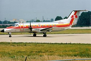
On April 9, 1990, Atlantic Southeast Airlines Flight 2254, a scheduled passenger flight from Muscle Shoals, Alabama, to Gadsden, Alabama, to Atlanta, Georgia, was involved in a mid-air collision with a Cessna 172 over Gadsden. The collision resulted in the death of the pilot and passenger of the Cessna 172.
Athens Municipal Airport is a city-owned public-use UNICOM airport located three nautical miles southeast of the central business district of Athens, in Henderson County, Texas, United States. It is mostly used for general aviation.

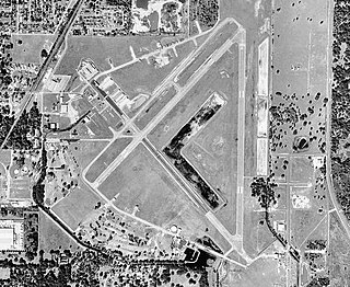
On May 30, 1972, Delta Air Lines Flight 9570 crashed while attempting to land at the Greater Southwest International Airport (GSW) in Fort Worth, Texas during a training flight. All four occupants aboard the training flight were killed. The crash was determined to be caused by the aircraft flying through wake turbulence, and led to sweeping changes in procedures for maintaining minimum safe distance behind aircraft that generate substantial wake turbulence.
Aero Country Airport is a privately owned public airport 4 nautical miles (7.4 km) west of the central business district of McKinney, Texas, United States. The airport has no IATA or ICAO designation.
Caddo Mills Municipal Airport is a city-owned public airport 2 nautical miles (3.7 km) southwest of the central business district of Caddo Mills, Texas, United States. The airport has no IATA or ICAO designation.
Parker County Airport is a privately owned public airport in Hudson Oaks, Parker County, Texas, United States. The airport serves the city of Weatherford, and is located approximately 5 nautical miles (9.3 km) east of the central business district.