
The 1958 Atlantic hurricane season included every tropical cyclone either affecting or threatening land. There were ten named storms as well as one pre-season tropical storm. Seven of the storms became hurricanes, including five that were major hurricanes, or the equivalent of a Category 3 on the Saffir-Simpson scale. The strongest storm was Hurricane Helene, which became a strong Category 4 hurricane with 150 mph (240 km/h) winds and a barometric pressure of 930 millibars (27 inHg) while just offshore the southeastern United States.

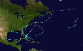
The 1961 Atlantic hurricane season was a very active Atlantic hurricane season, with an accumulated cyclone energy (ACE) total of 189. The season, however, was an average one in terms of named storms. The season featured eight hurricanes and a well above average number of five major hurricanes. It was previously thought that the season had a record-tying seven major hurricanes, before the Atlantic hurricane reanalysis project downgraded two storms in 2019. Two Category 5 hurricanes were seen in 1961, making it one of only seven Atlantic hurricane seasons to feature multiple Category 5 hurricanes in one season. The season started on June 15, and ended on November 15. These dates conventionally delimit the period of each year when most tropical cyclones form in the Atlantic basin. The first system, an operationally unclassified tropical depression, formed offshore east Central Florida on June 10, but dissipated a few days later. Next, Hurricane Anna developed in the eastern Caribbean Sea near the Windward Islands on July 20. It brought minor damage to the islands, as well as wind and flood impacts to Central America after striking Belize as a hurricane. Anna caused one death and about $300,000 (1961 USD) in damage. Activity went dormant for nearly a month and a half, until Hurricane Betsy developed on September 2. Betsy peaked as a Category 4 hurricane, but remained at sea and caused no impact.

The 1965 Atlantic hurricane season was the first to use the modern-day bounds for an Atlantic hurricane season, which are June 1 to November 30. These dates conventionally delimit the period of each year when most tropical cyclones form in the Atlantic basin. It was a slightly below average season, with 10 tropical cyclones developing and reaching tropical storm intensity. Four of the storms strengthened into hurricanes. One system reached major hurricane intensity – Category 3 or higher on the Saffir–Simpson hurricane scale. The first system, an unnamed tropical storm, developed during the month of June in the southern Gulf of Mexico. The storm moved northward across Central America, but caused no known impact in the region. It struck the Florida Panhandle and caused minor impact across much of the Southern United States. Tropical cyclogenesis halted for over two months, until Anna formed on August 21. The storm remained well away from land in the far North Atlantic Ocean and caused no impact.

The 1968 Atlantic hurricane season was a below average hurricane season during which only nine nameable storms developed. The season officially began on June 1 and lasted until November 30, dates which conventionally delimit the period of each year when most tropical cyclones form in the Atlantic basin. Of the named storms, five strengthened into hurricanes; none however intensified into a major hurricane. Only four other seasons since the start of the satellite era—1972, 1986, 1994, and 2013—did not feature a major hurricane. The first system, Hurricane Abby, developed in the northwestern Caribbean on June 1. Abby moved northward and struck Cuba, bringing heavy rainfall and flooding to western portions of the island. Making landfall in Florida on June 4, Abby caused flooding and spawned four tornadoes, but left behind little damage. Overall, the hurricane resulted in six deaths and about $450,000 (1968 USD) in damage. In late June, Tropical Storm Candy brought minor flooding and spawned several tornadoes across portions of the Southern United States. Overall damage from the cyclone reached approximately $2.7 million. 1968 featured two simultaneously active tropical storms during the month of June, a phenomenon that would not occur again until 2023.

The 1969 Atlantic hurricane season was the most active Atlantic hurricane season since the 1933 season, and was the final year of the most recent positive ("high-quality") Atlantic multidecadal oscillation (AMO) era. The hurricane season officially began on June 1, and lasted until November 30. Altogether, 12 tropical cyclones reached hurricane strength, the highest number on record at the time; a mark not surpassed until 2005. The season was above-average despite an El Niño, which typically suppresses activity in the Atlantic Ocean, while increasing tropical cyclone activity in the Pacific Ocean. Activity began with a tropical depression that caused extensive flooding in Cuba and Jamaica in early June. On July 25, Tropical Storm Anna developed, the first named storm of the season. Later in the season, Tropical Depression Twenty-Nine caused severe local flooding in the Florida Panhandle and southwestern Georgia in September.

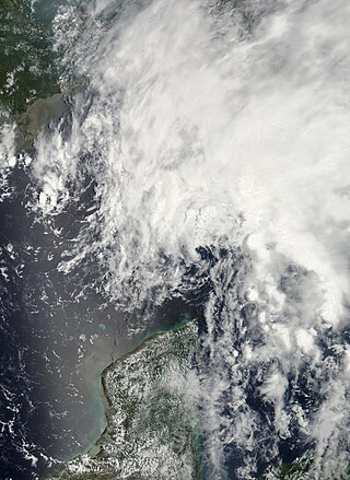
The 1972 Atlantic hurricane season was a significantly below average season, having only seven named storms, four fully tropical storms and three subtropical storms. It officially began on June 1, 1972, and lasted until November 30, 1972. These dates conventionally delimit the period of each year when most tropical cyclones form in the Atlantic basin. The first storm, Subtropical Storm Alpha, developed on May 23 off the Southeast United States and struck Florida, causing minor damage and two fatalities.
The 1946 Atlantic hurricane season resulted in no fatalities in the United States. The season officially began on June 15, 1946, and lasted until November 15, 1946. These dates conventionally delimit the period of each year when most tropical cyclones form in the Atlantic basin. However, the first storm, developed in the Gulf of Mexico on June 13, while the final system dissipated just offshore Florida on November 3. There were seven tropical storms; three of them attained hurricane status, while none intensified into major hurricanes, which are Category 3 or higher on the modern-day Saffir–Simpson hurricane wind scale. This had not occurred since 1940 and would not again until 1968. Operationally, the fifth tropical storm, which existed near the Azores in early October, was not considered a tropical cyclone but was added to HURDAT in 2014.
The 1927 Atlantic hurricane season was a relatively inactive season, with eight tropical storms, four of which became hurricanes. One of these became a major hurricane – Category 3 or higher on the modern day Saffir–Simpson scale. The first system, a tropical depression, developed on August 13, while the final cyclone, a tropical storm, merged with a cold front on November 21. No hurricane made landfall in the United States, in contrast to the four that struck the U.S. in the previous season.

The 1901 Atlantic hurricane season was the most active season without a major hurricane – tropical cyclones that reach at least Category 3 on the Saffir–Simpson hurricane wind scale – until 2013. The first system was initially observed in the northeastern Caribbean on June 11. The fourteenth and final system transitioned into an extratropical cyclone near Bermuda on November 5. These dates fall within the period with the most tropical cyclone activity in the Atlantic. Eight of the fourteen tropical cyclones existed simultaneously.

The 1887 Atlantic hurricane season was the most active Atlantic hurricane season on record at the time in terms of number of known tropical storms formed, with 19. This total has since been equaled or surpassed multiple times. The 1887 season featured five off-season storms, with tropical activity occurring as early as May, and as late as December. It is also worthy of note that the volume of recorded activity was documented largely without the benefit of modern technology. Tropical cyclones during this era that did not approach populated areas or shipping lanes, especially if they were relatively weak and of short duration, may have remained undetected. Because technologies such as satellite monitoring were not available until the 1960s, historical data on tropical cyclones from this period may not be comprehensive. An undercount bias of zero to six tropical cyclones per year between 1851 and 1885 and zero to four per year between 1886 and 1910 has been estimated. Of the known 1887 cyclones, Tropical Storm One and Tropical Storm Three were first documented in 1996 by Jose Fernandez-Partagas and Henry Diaz. They also proposed large alterations to the known tracks of several of the other 1887 storms. Later re-analysis led to the known duration of Hurricane Six, and also that of Hurricane Fifteen, being increased.

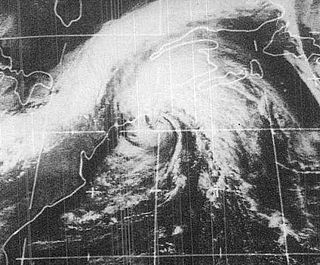
The 1952 Groundhog Day Storm was the only Atlantic tropical cyclone on record in February. First observed in the western Caribbean Sea on February 2 as a non-frontal low, it moved rapidly throughout its duration and struck southwestern Florida early the next day as a gale-force storm. In the state, the winds damaged some crops and power lines, but no serious damage was reported. The system became a tropical storm after emerging over the Atlantic Ocean before quickly transitioning into an extratropical cyclone on February 4. Strong winds and waves washed a freighter ashore, but no injuries were related to the event. Subsequently, the storm brushed eastern New England, causing minor power outages, before it moved inland near Maine. There were no reported fatalities related to the storm.

Hurricane Esther was the first large tropical cyclone to be discovered by satellite imagery. The fifth tropical cyclone, named storm, and hurricane of the 1961 Atlantic hurricane season, Esther developed from an area of disturbed weather hundreds of miles west-southwest of the southernmost Cape Verde Islands on September 10. Moving northwestward, the depression strengthened into Tropical Storm Esther on September 11, before reaching hurricane intensity on the following day. Early on September 13, Esther curved westward and deepened into a major hurricane. The storm remained a Category 3 hurricane for about four days and gradually moved in a west-northwestward direction. Late on September 17, Esther strengthened into a Category 5 hurricane with sustained winds of 160 mph (260 km/h) on September 18. The storm curved north-northeastward on September 19, while offshore of North Carolina. Esther began to weaken while approaching New England and fell to Category 3 intensity on September 21. The storm turned eastward early on the following day, and rapidly weakened to a tropical storm.

The 1933 Outer Banks hurricane lashed portions of the North Carolina and Virginia coasts less than a month after another hurricane hit the general area. The twelfth tropical storm and sixth hurricane of the 1933 Atlantic hurricane season, it formed by September 8 to the east of the Lesser Antilles. It moved generally to the north-northwest and strengthened quickly to peak winds of 140 mph (230 km/h) on September 12. This made it a major hurricane and a Category 4 on the Saffir-Simpson scale. The hurricane remained at or near that intensity for several days while tracking to the northwest. It weakened approaching the southeastern United States, and on September 16 passed just east of Cape Hatteras, North Carolina with winds of about 100 mph (160 km/h). Turning to the northeast, the hurricane became extratropical on September 18 before moving across Atlantic Canada, eventually dissipating four days later.
Tropical Storm Carrie was a strong tropical storm that affected the East Coast of the United States in early September 1972. The third tropical cyclone of the 1972 Atlantic hurricane season, Carrie formed on August 29 from a complex sequence of meteorological events starting with the emergence of a tropical wave into the Atlantic in the middle of August.
Hurricane Bertha caused minor damage in the United States, Bermuda, and Atlantic Canada in July and August 1990. The third tropical cyclone, second named storm, and first hurricane of the 1990 Atlantic hurricane season, Bertha developed from a frontal low pressure area offshore of North Carolina on July 24. Initially subtropical, it slowly acquired tropical characteristics while tracked southeast and then southwestward. By early on July 27, the cyclone was re-classified as a tropical depression. Following its transition, the depression intensified and was upgraded to Tropical Storm Bertha on July 28. The storm then curved northeastward and rapidly strengthened. Bertha became a hurricane early on July 29, though it weakened back to a tropical storm later that day. On the following day, Bertha re-intensified into a hurricane and peaked as an 80 mph (130 km/h) Category 1 hurricane on July 31.
Tropical Storm Barry was a rapidly forming tropical cyclone that made landfall on Florida, United States, in early June 2007. The second named storm of the 2007 Atlantic hurricane season, Barry developed from a trough of low pressure in the southeastern Gulf of Mexico on June 1. It tracked rapidly northeastward, reaching peak winds of 60 mph (97 km/h) before weakening and making landfall near Tampa Bay as a tropical depression. Barry quickly lost tropical characteristics after wind shear removed much of the convection, and early on June 3, it completed the transition into an extratropical cyclone. The extratropical remnants tracked up the East Coast of the United States, and were absorbed by a larger extratropical cyclone on June 5.

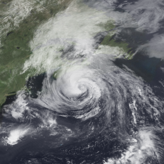
Hurricane Alma saw the latest development of the first storm since 1941. The first named storm of the 1962 Atlantic hurricane season, Alma formed from a tropical wave located offshore South Florida on August 26. Initially a tropical depression, it subsequently moved inland over South Florida. Impact in the state was minor, generally limited to light rainfall and rough seas. Early on August 27, the depression reemerged into the Atlantic Ocean and strengthened into Tropical Storm Alma later that day. Thereafter, it moved northeastward and remained offshore the East Coast of the United States. Alma strengthened into a hurricane on August 28, while located offshore the Outer Banks of North Carolina. In the eastern portion of the state, strong winds downed electrical poles, which caused power outages. Storm tides caused erosion in some areas. Damage in North Carolina reached $35,000 (1962 USD).

The 1940 New England hurricane moved off of the U.S. East Coast and Atlantic Canada in August and September 1940, producing strong winds and torrential rainfall. The fourth tropical cyclone and third hurricane of the season, the storm originated from a well-defined low-pressure area in the open Atlantic Ocean on August 26. Moving slowly in a general west-northwest motion, the disturbance intensified, reaching tropical storm strength on August 28 and subsequently hurricane intensity on August 30. The hurricane passed within 85 mi (137 km) of Cape Hatteras before recurving towards the northeast. The hurricane continued to intensify, and reached peak intensity as a Category 2 hurricane with maximum sustained winds of 110 mph (180 km/h) and a minimum barometric pressure of 961 mbar, though these statistical peaks were achieved at different times on September 2. Afterwards, the hurricane began a weakening trend as it proceeded northeastward, and had degenerated into a tropical storm by the time it made its first landfall on Nova Scotia later that day. The storm transitioned into an extratropical cyclone the next day while making another landfall on New Brunswick. The extratropical remnants persisted into Quebec before merging with a larger extratropical system late on September 3.


