Louisville Muhammad Ali International Airport, formerly known as simply Louisville International Airport, is a civil-military airport in Louisville in Jefferson County, Kentucky. The airport covers 1,500 acres (6.1 km2) and has three runways. Its IATA airport code, SDF, is based on the airport's former name, Standiford Field. Despite being called an international airport, it has no regularly-scheduled international passenger flights, but is a port of entry, handling many UPS Airlines international cargo flights through the United Parcel Service's worldwide air hub, often referred to as UPS Worldport.

Tallahassee International Airport is a city-owned airport five miles southwest of downtown Tallahassee, in Leon County, Florida, United States. It serves the state capital of Florida, and its surrounding areas; it is one of the major airports in north Florida, the others being Pensacola, Northwest Florida Beaches, and Jacksonville. Despite its name, it does not service any international destinations.
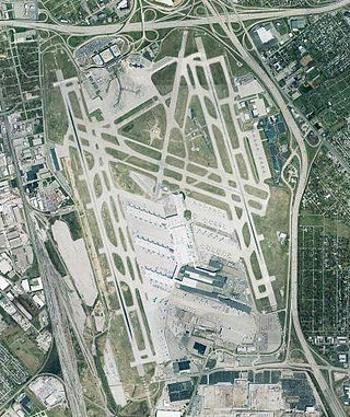
Nashville International Airport is a public/military airport in the southeastern section of Nashville, Tennessee, United States. Established in 1937, its original name was Berry Field, from which its ICAO and IATA identifiers are derived. The current terminal was built in 1987, and the airport took its current name in 1988. Nashville International Airport has four runways and covers 4,555 acres (1,843 ha) of land. It is by far the busiest airport in Tennessee, with more boardings and arrivals than all other airports in the state combined.

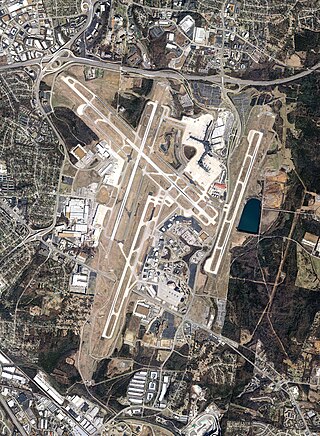
Piedmont Triad International Airport is an airport located in unincorporated Guilford County, North Carolina, west of Greensboro, serving the Piedmont Triad region of Greensboro, High Point and Winston-Salem as well as the entire Piedmont Triad region in North Carolina, United States. The airport, located just off Bryan Boulevard, sits on a 3,770 acre campus and has three runways. It is the third busiest airport in North Carolina, averaging 280 takeoffs and landings each day. PTI is owned and operated by the Piedmont Triad Airport Authority.

Kalamazoo/Battle Creek International Airport is a county-owned public airport in Kalamazoo, Kalamazoo County, Michigan, US, 3 miles (4.8 km) southeast of Downtown Kalamazoo. The airport is located approximately 20 miles (32 km) west of the city of Battle Creek. It is included in the Federal Aviation Administration (FAA) National Plan of Integrated Airport Systems for 2023-27, in which it is categorized as a non-hub primary commercial service facility.

Teterboro Airport is a general aviation relief airport in the boroughs of Teterboro, Moonachie, and Hasbrouck Heights in Bergen County, New Jersey. It is owned and managed by the Port Authority of New York and New Jersey and operated by AFCO AvPORTS Management. The airport is in the New Jersey Meadowlands, 12 miles (19 km) from Midtown Manhattan, which makes it popular for private and corporate aircraft. The airport has a weight limit of 100,000 pounds (45,000 kg) on aircraft, making it nonviable for commercial service.

Troutdale Airport, also known as Troutdale-Portland Airport, is a corporate, general aviation and flight-training airport serving the city of Troutdale, in Multnomah County, Oregon, United States. It is one of three airports in the Portland metropolitan area owned and operated by the Port of Portland. Troutdale Airport was established in 1920 as a private airfield, then purchased by the Port of Portland in 1942. It serves as a reliever airport for nearby Portland International Airport (PDX).
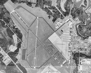
Evansville Regional Airport is three miles north of Evansville, in Vanderburgh County, Indiana, United States. It is owned and operated by the Evansville-Vanderburgh Airport Authority District.

Williamsport Regional Airport serves Williamsport, Pennsylvania, and the surrounding area with a population of roughly 200,000. The airport processes approximately 40,000 passengers annually and has served north central Pennsylvania since 1929.

Livermore Municipal Airport is three miles west of Livermore, California, in Alameda County, California. The Federal Aviation Administration (FAA) National Plan of Integrated Airport Systems for 2017–2021 categorized it as a regional reliever facility.

Abraham Lincoln Capital Airport is a civil-military airport in Sangamon County, Illinois, United States, three miles (6 km) northwest of downtown Springfield. It is owned by the Springfield Airport Authority (SAA).

Westfield-Barnes Regional Airport is a joint civil-military airport in Hampden County, Massachusetts, three miles (6 km) north of Westfield and northwest of Springfield. It was formerly Barnes Municipal Airport; the National Plan of Integrated Airport Systems for 2011–2015 categorized it as a general aviation facility. Westfield-Barnes is one of Massachusetts' largest airports with a strong flight training, general aviation, and military presence. It is also known as Barnes Air National Guard Base.

Monroe County Airport is a county-owned public-use airport located four nautical miles southwest of the central business district of Bloomington, a city in Monroe County, Indiana, United States. Commercial service has been available at different points in the airport's history but as of today and for the future, no scheduled service is available.
Ford Airport is a county-owned public-use airport in Dickinson County, Michigan, United States. It is located three miles west of the central business district of Iron Mountain, in the central Upper Peninsula of Michigan. The airport offers scheduled passenger service by one commercial airline, SkyWest Airlines, an affiliate of Delta Connection, which is subsidized by the Essential Air Service program. It is also a hub for FedEx Feeder operator CSA Air.
Smyrna Airport is a public general aviation and military use airport located two nautical miles (4 km) north of the central business district of Smyrna, a town in Rutherford County, Tennessee, United States. It is owned by the Smyrna / Rutherford County Airport Authority. Smyrna Airport is the third largest airport in Tennessee and is the state's busiest general aviation airport. Prior to March 1971, the facility was an active military installation known as Sewart Air Force Base.

Waterbury–Oxford Airport, also known as Oxford Airport, is a public airport located three miles (5 km) north of the central business district of Oxford, a town in New Haven County, Connecticut, United States.
Iowa City Municipal Airport, is two miles southwest of downtown Iowa City, in Johnson County, Iowa. It is the oldest civil airport west of the Mississippi River still in its original location.

Davenport Municipal Airport is a general aviation airport located about 7 miles (11 km) north of downtown Davenport, a city in Scott County, Iowa, United States. The airport, which dates back to 1948, has been home to the Quad City Air Show since 1987.

Pittsburgh-Butler Regional Airport, also known as the Butler County Airport or K. W. Scholter Field, is a public airport 5 miles (8 km) southwest of the central business district of Butler, the county seat of Butler County, Pennsylvania, United States. The airport serves the northern suburbs of the Pittsburgh metropolitan area. It is owned by the Butler County Airport Authority.
Fort Worth Spinks Airport is a city-owned, public-use airport located 14 nautical miles (26 km) south of the central business district of Fort Worth, in Tarrant County, Texas, United States. It is the newest of the three airports that are owned by the City of Fort Worth and it serves the cities of Fort Worth, Burleson, and Mansfield. The airport is located at the intersection of Interstate 35W and HWY 1187 and serves as a reliever airport for Fort Worth Meacham International Airport and Dallas–Fort Worth International Airport and has Class D designation.