
Azusa is a city in the San Gabriel Valley region of Los Angeles County, California United States at the foot of the San Gabriel Mountains located 20 miles (32 km) east of downtown Los Angeles.

Colorado Boulevard is a major east–west street in Southern California. It runs from Griffith Park in Los Angeles east through Glendale, the Eagle Rock section of Los Angeles, Pasadena, and Arcadia, ending in Monrovia. The full route was once various state highways but is now locally maintained in favor of the parallel Ventura Freeway and Foothill Freeway (I-210).

Hastings Ranch is a neighborhood of Pasadena, California which lies in northeast Pasadena. It is principally accessed by Sierra Madre Boulevard, Michillinda Avenue, Hastings Ranch Blvd., and Riviera Drive. Hastings Ranch is also identified by large shopping areas at its southernmost end and by a shopping center at the corner of Sierra Madre and Michillinda. Hastings Ranch is divided by Sierra Madre Blvd, north of the blvd is Upper Hastings Ranch and south is Lower Hastings Ranch. To the north of the Ranch is the San Gabriel Mountains and Mount Wilson.

Sierra Madre Boulevard is a 6.6-mile (10.6 km) long road connecting five suburbs of Pasadena, California; Arcadia, Sierra Madre, Hastings Ranch, East Pasadena, and San Marino.

State Route 19 is a state highway in the U.S. state of California, running along Lakewood Boulevard and Rosemead Boulevard in the Los Angeles area. An additional "hidden" state highway, State Route 164, is also signed as part of SR 19, despite having a legal description separate from Route 19. The combined route is a north–south four-to-six lane suburban roadway, lying east of the Long Beach Freeway and west of the San Gabriel River Freeway, and connecting the eastern parts of Long Beach and Pasadena via the Whittier Narrows. Under their legal descriptions, SR 19 runs north to Gallatin Road in Pico Rivera, then SR 164 goes from Gallatin Road to Pasadena. Since 1998, several pieces have been relinquished to local governments, and more transfers are authorized by state law.
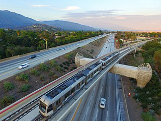
The A Line is a 48.5-mile (78.1 km) light rail line in Los Angeles County, California. The A Line runs east-west between Azusa and Pasadena, then north-south between Pasadena and Long Beach, via Downtown Los Angeles. The A Line is currently the longest light rail line in the world.
The L Line and Gold Line are former designations for a section of the current Los Angeles Metro Rail system. These names referred to a single light rail line of 31 miles (50 km) providing service between Azusa and East Los Angeles via the northeastern corner of Downtown Los Angeles, serving several attractions, including Little Tokyo, Union Station, the Southwest Museum, Chinatown, and the shops of Old Pasadena. The line, formerly one of seven in the system, entered service in 2003. The L Line served 26 stations.

Located in Los Angeles County, California's San Gabriel Valley, the Boy Scouts of America's San Gabriel Valley Council (#40) was one of five councils serving Los Angeles County. It was headquartered in Pasadena.
Foothill Boulevard is a major road in the city and county of Los Angeles, as well as an arterial road in the city and county of San Bernardino, stretching well over 60 miles (97 km) in length, with some notable breaks along the route. Like its name implies, Foothill Boulevard runs across the foothills of the San Gabriel and San Bernardino Mountains.

Sierra Madre Villa station is a light rail station on the A Line of the Los Angeles Metro Rail system. It is located in the median of Interstate 210, at Sierra Madre Villa Avenue, in Pasadena, California. The light rail station opened on July 26, 2003, as the northern terminus of the original Gold Line, then known as the "Pasadena Metro Blue Line" project. The station, under naming schemes, is named for Sierra Madre Villa Avenue rather than the nearby city of Sierra Madre, although the major thoroughfare leads to Sierra Madre.

Eaton Canyon is a major canyon beginning at the Eaton Saddle near Mount Markham and San Gabriel Peak in the San Gabriel Mountains in the Angeles National Forest, United States. Its drainage flows into the Rio Hondo river and then into the Los Angeles River. It is named after Judge Benjamin S. Eaton, who lived in the Fair Oaks Ranch House in 1865 not far from Eaton Creek.
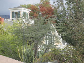
Crank House, also known as Fair Oaks Ranch, is an 1882 Victorian style residence in Altadena, Los Angeles County, California. The house was placed on the National Register of Historic Places in 1997 for its association with the early settlement of Altadena. (site #97000751). The house has notably featured in films such as Hocus Pocus, Matilda, Scream 2 and Catch Me If You Can.
The Pasadena Subdivision is the remnant branch line of the former Atchison, Topeka and Santa Fe Railway (AT&SF) Los Angeles Second District. The line currently branches off of Metrolink’s San Bernardino Line at CP Cambridge in Claremont. The line follows a generally east–west alignment, passed through the cities of Claremont, Pomona, La Verne, San Dimas, Glendora, and Azusa before coming to a truncated end in Irwindale. For most of its length, it shares the corridor with the Los Angeles Metro Rail’s A Line. Recent construction, known as the Foothill Extension Phase 2B, has seen the tracks out of service west of San Dimas for most of 2021.

The Monrovia–Glendora Line was a route on the Pacific Electric Railway serving the San Gabriel Valley. It operated from 1902 to 1951, supporting nearby real estate development.
California Village is a neighborhood in Pasadena, California. It is bordered by Sierra Madre Boulevard to the north, Foothill Boulevard to the south, the Eaton Wash to the west, and Sierra Madre Villa Avenue to the east. Like most of the neighborhoods east of the Eaton Wash, it was developed more recently than most other neighborhoods in Pasadena.
Chapman, also known as Chapman Woods is a neighborhood in southern California. Most of the neighborhood is in unincorporated East Pasadena, California, with a small portion extending into Pasadena, California. It is bordered by Del Mar Boulevard to the north, Huntington Drive to the south, the Eaton Wash to the west, and Highway 19 to the east. Chapman is an anomaly in that part of the neighborhood is in incorporated Pasadena while part is in unincorporated Los Angeles County. The region is named after Alfred Chapman who purchased the surrounding land and built his home on the corner of present-day California Boulevard and Ivydale Court.
Daisy-Villa is a neighborhood in Pasadena, California. It is bordered by Sierra Madre Boulevard to the west, Orange Grove Boulevard to the north, the 210 Freeway to the south, and the Eaton Wash to the east. Daisy-Villa is an exclusively residential neighborhood with approximately 350 homes. The neighborhood is named after two streets that meet in the center of the community.
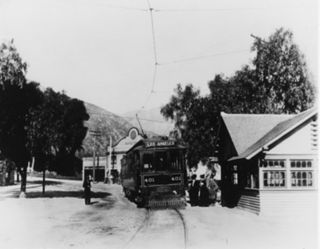
The Sierra Madre Line was a Pacific Electric interurban route which ran 16.52 miles (26.59 km) from the Pacific Electric Building in Los Angeles to Sierra Madre.
The Foothill Extension Project, formerly known as the Gold Line Foothill Extension Project, is an extension of the Los Angeles Metro Rail A Line light rail line from the former Gold Line terminus in Pasadena, California, at Sierra Madre Villa station, east through the "Foothill Cities" of Los Angeles County. The plan's first stage, Phase 2A, extended the then-Gold Line from Pasadena to Azusa; it opened on March 5, 2016. Phase 2B, which will extend the now A Line a further four stations to Pomona–North station, broke ground in December 2017. A further two–station extension to Montclair Transcenter is planned for completion in 2028, but is currently unfunded.

The Los Angeles and San Gabriel Valley Railroad was a railroad founded on September 5, 1883, by James F. Crank with the goal of bringing a rail line to Pasadena, California from downtown Los Angeles, the line opened in 1886. Los Angeles and San Gabriel Valley Railroad was sold and consolidated on May 20, 1887 into the California Central Railway. In 1889 this was consolidated into Southern California Railway Company. On Jan. 17, 1906 Southern California Railway was sold to the Atchison, Topeka and Santa Fe Railway and called the Pasadena Subdivision. The main line closed in 1994. The railroad later reopened as the MTA Gold Line Light Rail service in July 2003.


