
Yukon is the smallest and westernmost of Canada's three territories. It is the third-least populated province or territory in Canada, with a population of 45,148 as of 2023. However, Whitehorse, the territorial capital, is the largest settlement in any of the three territories.

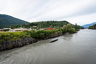
The Yukon River is a major watercourse of northwestern North America. From its source in British Columbia, Canada, it flows through Canada's territory of Yukon. The lower half of the river continues westward through the U.S. state of Alaska. The river is 3,190 kilometres (1,980 mi) long and empties into the Bering Sea at the Yukon–Kuskokwim Delta. The average flow is 6,400–7,000 m3/s (230,000–250,000 cu ft/s). The total drainage area is 833,000 km2 (321,500 sq mi), of which 323,800 km2 (125,000 sq mi) lies in Canada. The total area is more than 25% larger than Texas or Alberta.
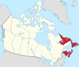
Atlantic Canada, also called the Atlantic provinces, is the region of Eastern Canada comprising the provinces located on the Atlantic coast, excluding Quebec. The four provinces are New Brunswick, Newfoundland and Labrador, Nova Scotia, and Prince Edward Island. As of 2021, the landmass of the four Atlantic provinces was approximately 488,000 km2 (188,000 sq mi), and had a population of over 2.4 million people. The provinces combined had an approximate GDP of $121.888 billion in 2011. The term Atlantic Canada was popularized following the admission of Newfoundland as a Canadian province in 1949.
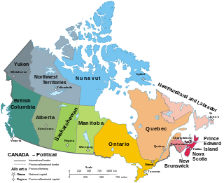
Canada has ten provinces and three territories that are sub-national administrative divisions under the jurisdiction of the Canadian Constitution. In the 1867 Canadian Confederation, three provinces of British North America—New Brunswick, Nova Scotia, and the Province of Canada —united to form a federation, becoming a fully independent country over the next century. Over its history, Canada's international borders have changed several times as it has added territories and provinces, making it the world's second-largest country by area.

Aklavik is a hamlet located in the Inuvik Region of the Northwest Territories, Canada. Until 1961, with a population over 1,500, the community served as the regional administrative centre for the territorial government.

The Gwichʼin language belongs to the Athabaskan language family and is spoken by the Gwich'in First Nation (Canada) / Alaska Native People. It is also known in older or dialect-specific publications as Kutchin, Takudh, Tukudh, or Loucheux. Gwich'in is spoken primarily in the towns of Inuvik, Aklavik, Fort McPherson, and Tsiigehtchic, all in the Northwest Territories and Old Crow in Yukon of Canada. In Alaska of the United States, Gwichʼin is spoken in Beaver, Circle, Fort Yukon, Chalkyitsik, Birch Creek, Arctic Village, Eagle, and Venetie.
The Nass River is a river in northern British Columbia, Canada. It flows 380 km (240 mi) from the Coast Mountains southwest to Nass Bay, a sidewater of Portland Inlet, which connects to the North Pacific Ocean via the Dixon Entrance. Nass Bay joins Portland Inlet just south of Observatory Inlet.
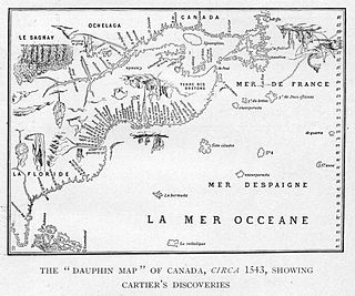
While a variety of theories have been postulated for the name of Canada, its origin is now accepted as coming from the St. Lawrence Iroquoian word kanata, meaning 'village' or 'settlement'. In 1535, indigenous inhabitants of the present-day Quebec City region used the word to direct French explorer Jacques Cartier to the village of Stadacona. Cartier later used the word Canada to refer not only to that particular village but to the entire area subject to Donnacona ; by 1545, European books and maps had begun referring to this small region along the Saint Lawrence River as Canada.

Tsiigehtchic, officially the Charter Community of Tsiigehtchic, is a Gwich'in community located at the confluence of the Mackenzie and the Arctic Red Rivers, in the Inuvik Region of the Northwest Territories, Canada. The community was formerly known as Arctic Red River, until 1 April 1994. The Gwichya Gwich'in First Nation is located in Tsiigehtchic.

Hopedale is a town located in the north of Labrador, the mainland portion of the Canadian province of Newfoundland and Labrador. Hopedale is the legislative capital of the Inuit Land Claims Area Nunatsiavut, and where the Nunatsiavut Assembly meets. As of the 2021 census, it has a population of 596.

Whiteshell Provincial Park is a provincial park in southeast Manitoba, approximately 120 kilometres (75 mi) east of the city of Winnipeg. The park is considered to be a Class II protected area under the IUCN protected area management categories. It is 275,210 hectares in size.
English orthography sometimes uses the term proper adjective to mean adjectives that take initial capital letters, and common adjective to mean those that do not. For example, a person from India is Indian—Indian is a proper adjective.

Acadia Valley is a hamlet in southeast Alberta, Canada within the Municipal District (MD) of Acadia No. 34. The MD of Acadia No. 34's municipal office is located in Acadia Valley.
Robert Arthur Alexie was a Canadian First Nations novelist and a land claim negotiator who played a key role in land claim agreements in the Northwest Territories.

The Mnjikaning Fish Weirs are one of the oldest human developments in Canada. These fishing weirs were built by the first nations people well before recorded history, dating to around 4500 BP during the Archaic period in North America, according to carbon dating done on some of the wooden remnants. The weirs were built in the narrows between Lake Couchiching and Lake Simcoe, now known as Atherley Narrows, over which Ontario Highway 12 passes today. They were preserved by the water and layers of protective silt.

This is a bibliography of works on the Provinces and territories of Canada.


