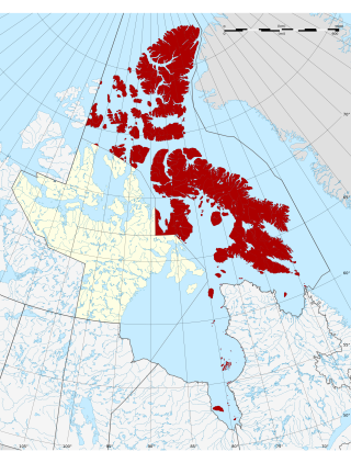
Arctic islands

Islands and island groups in the Arctic Archipelago include (all islands in Nunavut unless noted):
Contents
- Arctic islands
- Queen Elizabeth Islands
- Belcher Islands
- Other Arctic islands
- Newfoundland and Labrador
- Nova Scotia
- Prince Edward Island
- New Brunswick
- Quebec
- Ontario
- Manitoba
- Saskatchewan
- Alberta
- British Columbia
- Additional notes
- See also
- References
Queen Elizabeth Islands
The Queen Elizabeth Islands consist of:
- Adams Island
- Alexander Island
- Baillie-Hamilton Island
- Borden Island [lower-alpha 1]
- Brock Island [lower-alpha 2]
- Buckingham Island
- Byam Martin Island
- Cameron Island
- Coburg Island
- Cornwall Island
- Devon Island
- Eglinton Island [lower-alpha 2]
- Ellesmere Island [lower-alpha 3]
- Emerald Isle [lower-alpha 2]
- Graham Island
- Griffith Island
- Helena Island
- Hoved Island
- Île Vanier
- King Christian Island
- Little Cornwallis Island
- Lougheed Island
- Mackenzie King Island [lower-alpha 1]
- Massey Island
- Meighen Island
- North Kent Island
- Pioneer Island
- Prince Patrick Island [lower-alpha 2]
- Stor Island
- 2,092 other minor islands including Hans Island (with Denmark) (Inuktitut: Tartupaluk), a small uninhabited barren knoll off Ellesmere Island, measuring 1.3 km2 (0.50 sq mi)
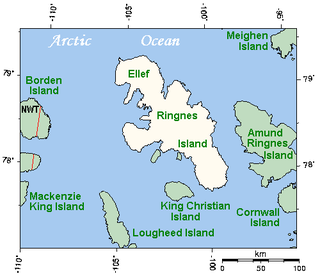
Sverdrup Islands
The Sverdrup Islands, an archipelago of the northern Queen Elizabeth Islands, include:
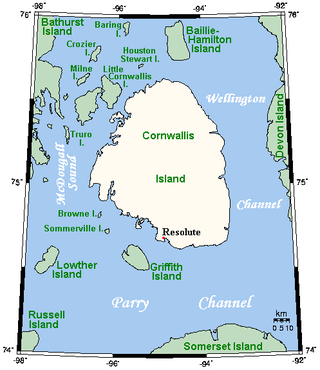
Parry Islands
The Parry Islands, an archipelago of the northern Queen Elizabeth Islands, include: [1]
- Bathurst Island
- Cornwallis Island [lower-alpha 3]
- Melville Island [lower-alpha 1]
- Berkeley Islands (a subgroup of the Parry Islands)
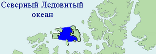
Belcher Islands
The Belcher Islands consist of:
- Flaherty Island [lower-alpha 3]
- Innetalling Island
- Kugong Island
- Mavor Island
- Moore Island
- Snape Island
- Split Island
- Tukarak Island
- Wiegand Island
Other Arctic islands
- Adams Island
- Air Force Island
- Akimiski Island
- Akpatok Island
- Angijak Island
- Baffin Island [lower-alpha 3]
- Banks Island [lower-alpha 2] [lower-alpha 3]
- Bray Island
- Brevoort Island
- Broughton Island [lower-alpha 3]
- Bylot Island
- Charles Island
- Charlton Island
- Coats Island
- Crown Prince Frederik Island
- Dexterity Island
- Dorset Island [lower-alpha 3]
- Edgell Island
- Foley Island
- Herschel Island [lower-alpha 2] (Inuvialuktun: Qikiqtaruk)
- Igloolik Island [lower-alpha 3]
- Kapuiviit (formerly Jens Munk Island)
- Killiniq Island
- King William Island [lower-alpha 3]
- Koch Island
- Loks Land
- Long Island (Frobisher Bay)
- Long Island (Hudson Bay)
- Mansel Island
- Matty Island
- Mill Island
- Moodie Island
- Nagjuttuuq (formerly Vansittart Island)
- North Twin Island
- Nottingham Island
- O'Reilly Island
- Paallavvik (formerly Padloping Island)
- Pandora Island
- Prescott Island
- Prince Charles Island
- Prince of Wales Island
- Qikiqtaaluk (formerly Sillem Island)
- Qikiqtaaluk (Foxe Basin) (formerly White Island)
- Qikiqtagafaaluk (formerly Admiralty Island)
- Qikiqtarjuaq (formerly Big Island)
- Qikiqtaryuaq (formerly Jenny Lind Island)
- Qikiqtaryuaq (Queen Maud Gulf) (formerly Melbourne Island)
- Resolution Island
- Richards Island [lower-alpha 2]
- Rowley Island
- Russell Island
- Salisbury Island
- Smith Island (Frobisher Bay)
- Smith Island (Hudson Bay)
- Somerset Island
- Southampton Island [lower-alpha 3]
- South Tweedsmuir Island
- Stefansson Island
- Tennent Islands
- Umingmalik (formerly Gateshead Island)
- Victoria Island [lower-alpha 1] [lower-alpha 3]
- Wales Island (Nunavut)
- Wales Island (Ungava)
- 34,377 other minor islands