Central Canada

Last updated

Central Canada
Centre du Canada (French)
Central provinces in Canada.svg
Map of Central Canada, defined politically
Coordinates: 50°N79°W / 50°N 79°W / 50; -79
Composition
Largest city Toronto
Largest metro Greater Toronto Area
Canadian Confederation 1 July 1867
Area
 (2021 - land, [1] 2017 - fresh water [2] [3] )
  Total2,552,291.51 km2 (985,445.26 sq mi)
  Land2,191,011.51 km2 (845,954.27 sq mi)
  Water361,280.00 km2 (139,490.99 sq mi)
Population
 (2021 [1] )
  Total22,725,775
  Density10.4/km2 (27/sq mi)
Time zones
Western Ontario UTC−06:00 (CST)
  Summer (DST) UTC−05:00 (CDT)
Eastern Ontario / most of Quebec UTC−05:00 (EST)
  Summer (DST) UTC−04:00 (EDT)
Eastern Quebec UTC−04:00 (AST)
  Summer (DST) UTC−03:00 (ADT)

Central Canada (French : Centre du Canada, sometimes the Central provinces) is a Canadian region consisting of Ontario and Quebec, the largest and most populous provinces of the country. [4] Geographically, they are not at the centre of Canada but instead overlap with Eastern Canada toward the east. Because of their large populations, Ontario and Quebec have traditionally held a significant amount of political power in Canada, leading to some amount of resentment from other regions of the country. Before Confederation, the term "Canada" specifically referred to Central Canada. Today, the term "Central Canada" is less often used than the names of the individual provinces.

Contents

History

Before Confederation, the region known as Canada was what is now called Central Canada. Southern Ontario was once called Upper Canada and later Canada West, and southern Quebec was called Lower Canada and later Canada East. Both were part of the United Province of Canada in 1841. [5]

Geography

Ontario, Canada's fourth largest subdivision (after Nunavut, Quebec, and the Northwest Territories), had, at the 2021 Canadian census, a land area of 892,411.76 km2 (344,562.11 sq mi) [1] (10.15 per cent of Canada and the fifth largest after Nunavut, Quebec, the Northwest Territories, and British Columbia) and as of 2017, there was 177,390 km2 (68,490 sq mi) [2] (21.55 per cent of Canada and the second largest after Quebec) of fresh water, for a total area of 1,069,801.76 km2 (413,052.77 sq mi) (11.13 per cent of Canada).

Quebec, Canada's second largest subdivision and largest province, had, at the 2021 Canadian census, a land area of 1,298,599.75 km (806,912.47 mi) [1] (14.78 per cent of Canada and the second largest after Nunavut), and as of 2017, there was 183,890 km2 (71,000 sq mi) [3] (22.34 per cent and the largest in Canada) of fresh water, for a total area of 1,482,489.75 km2 (572,392.49 sq mi) (15.42 per cent of Canada).

Together the two provinces have a land area of 2,191,011.51 km2 (845,954.27 sq mi) (24.93 per cent), 361,280.00 km2 (139,490.99 sq mi) (43.89 per cent) fresh water for a total area of 2,552,291.51 km2 (985,445.26 sq mi) (26.55 per cent). [1] [2] [3]

Although the region is called Central Canada the actual centre of Canada can be defined in multiple ways. The longitudinal centre of Canada is located just east of Winnipeg, Manitoba, on Highway 1 East, part of the Trans-Canada Highway. [6] The latitudinal centre is at 62 degrees, 24 minutes north, meaning the geographic centre of Canada is located just south of Yathkyed Lake, Nunavut. [7]

Physical geography

Ontario

Typical landscape of the Canadian Shield at Queen Elizabeth II Wildlands Provincial Park, located in Central Ontario. BlackRiver1.JPG
Typical landscape of the Canadian Shield at Queen Elizabeth II Wildlands Provincial Park, located in Central Ontario.

The thinly populated Canadian Shield, which dominates the northwestern and central portions of the province, comprises over half the land area of Ontario. Although this area mostly does not support agriculture, it is rich in minerals, partly covered by the Central and Midwestern Canadian Shield forests, and studded with lakes and rivers. Northern Ontario is subdivided into two sub-regions: Northwestern Ontario and Northeastern Ontario.

The virtually unpopulated Hudson Bay Lowlands in the extreme north and northeast are mainly swampy and sparsely forested.

Southern Ontario, which is further sub-divided into four sub-regions: Central Ontario (although not actually the province's geographic centre), Eastern Ontario, Golden Horseshoe and Southwestern Ontario (parts of which were formerly referred to as Western Ontario).

Despite the rarity of mountainous terrain in the province, there are large areas of uplands, particularly within the Canadian Shield which traverses the province from northwest to southeast and also above the Niagara Escarpment which crosses the south. The highest point is Ishpatina Ridge at 693 metres (2,274 ft) above sea level in Temagami, Northeastern Ontario. In the south, elevations of over 500 m (1,640 ft) are surpassed near Collingwood, above the Blue Mountains in the Dundalk Highlands and in hilltops near the Madawaska River in Renfrew County.

The Carolinian forest zone covers most of the southwestern region of the province. The temperate and fertile Great Lakes-Saint Lawrence Valley in the south is part of the Eastern Great Lakes lowland forests ecoregion where the forest has now been largely replaced by agriculture, industrial and urban development. A well-known geographic feature is Niagara Falls, part of the Niagara Escarpment. The Saint Lawrence Seaway allows navigation to and from the Atlantic Ocean as far inland as Thunder Bay in Northwestern Ontario. Northern Ontario covers approximately 87% of the province's surface area; conversely, Southern Ontario contains 94% of the population.

Point Pelee is a peninsula of Lake Erie in southwestern Ontario (near Windsor and Detroit, Michigan) that is the southernmost extent of Canada's mainland. Pelee Island and Middle Island in Lake Erie extend slightly farther. All are south of 42°N  – slightly farther south than the northern border of California.

Quebec

Map of Quebec Map of Quebec.png
Map of Quebec

Located in the eastern part of Canada, Quebec occupies a territory nearly three times the size of France or Texas. Most of Quebec is very sparsely populated. [8] The most populous physiographic region is the Great Lakes–St. Lawrence Lowlands. The combination of rich soils and the lowlands' relatively warm climate makes this valley the most prolific agricultural area of Quebec. The rural part of the landscape is divided into narrow rectangular tracts of land that extend from the river and date back to the seigneurial system.

Quebec's topography is very different from one region to another due to the varying composition of the ground, the climate, and the proximity to water. More than 95% of Quebec's territory, including the Labrador Peninsula, lies within the Canadian Shield. [9] It is generally a quite flat and exposed mountainous terrain interspersed with higher points such as the Laurentian Mountains in southern Quebec, the Otish Mountains in central Quebec and the Torngat Mountains near Ungava Bay. While low and medium altitude peaks extend from western Quebec to the far north, high altitudes mountains emerge in the Capitale-Nationale region to the extreme east. Quebec's highest point at 1,652 metres (5,420 ft) is Mont d'Iberville, known in English as Mount Caubvick. [10] In the Labrador Peninsula portion of the Shield, the far northern region of Nunavik includes the Ungava Peninsula and consists of flat Arctic tundra inhabited mostly by the Inuit. Further south is the Eastern Canadian Shield taiga ecoregion and the Central Canadian Shield forests. The Appalachian region has a narrow strip of ancient mountains along the southeastern border of Quebec.

Michel's falls on Ashuapmushuan River in Saint-Felicien, Saguenay-Lac-Saint-Jean Chutes a Michel.jpg
Michel's falls on Ashuapmushuan River in Saint-Félicien, Saguenay–Lac-Saint-Jean

Quebec has one of the world's largest reserves of fresh water, [11] occupying 12% of its surface [12] and representing 3% of the world's renewable fresh water. [13] More than half a million lakes and 4,500 rivers [11] empty into the Atlantic Ocean, through the Gulf of Saint Lawrence and the Arctic Ocean, by James, Hudson, and Ungava bays. The largest inland body of water is the Caniapiscau Reservoir; Lake Mistassini is the largest natural lake. [14] The Saint Lawrence River has some of the world's largest sustaining inland Atlantic ports. Since 1959, the Saint Lawrence Seaway has provided a navigable link between the Atlantic Ocean and the Great Lakes.

The public lands of Quebec cover approximately 92% of its territory, including almost all of the bodies of water. Protected areas can be classified into about twenty different legal designations (ex. exceptional forest ecosystem, protected marine environment, national park, biodiversity reserve, wildlife reserve, zone d'exploitation contrôlée (ZEC), etc.). [15] More than 2,500 sites in Quebec today are protected areas. [16] As of 2013, protected areas comprise 9.14% of Quebec's territory. [17]

Population

Ontario and Quebec are the two most populous provinces in Canada, accounting for 61.43 per cent of Canada's population. [1] As of the 2021 census conducted by Statistics Canada there were 22,725,775 people in the two provinces, and represented an increase of 5.1 per cent over the 2016 census figure of 21,612,855 people. [1] The land area was 2,191,011.51 km2 (845,954.27 sq mi) giving a population density of

The median age of Ontario was 41.6, identical to Canada as a whole, and Quebec's population was slightly older at 43.2. [18]

Population of visible minority, Indigenous, and others (2021 Canadian census [18] )
OntarioQuebecCentral CanadaCanada
Population groupPopulation
 
 % of
province
Population
 
% of
province
Population
 
% of
Central Canada
% of
Canada
Population
 
%
 
Non-visible minority or Indigenous8,807,80562.8%6,762,73581.4%15,570,54161.4%42.9%25,364,14069.8%
Visible minority group South Asian 1,515,29510.8%127,9901.5%1,643,2857.4%4.5%2,571,4007.1%
Chinese 820,2455.8%115,2401.4%935,4854.2%2.6%1,715,7704.7%
Black 768,7405.5%422,4055.1%1,191,1455.3%3.3%1,574,8704.3%
Filipino 363,6502.6%44,8850.5%408,5351.8%1.1%957,3552.6%
Arab 284,2152.0%280,0753.4%564,2902.5%1.6%694,0151.9%
Latin American 249,1901.8%172,9252.1%422,1151.9%1.2%580,2351.6%
Southeast Asian 167,8451.2%70,4550.8%238,3001.1%0.7%390,3401.1%
West Asian 212,1851.5%43,9850.5%256,1701.1%0.7%360,4951.0%
Korean 99,4250.7%10,3600.1%109,7850.5%0.3%218,1400.6%
Japanese 31,4200.2%5,3050.1%36,7250.2%0.1%98,8900.3%
Visible minority, n.i.e.124,1200.9%12,1500.1%136,2700.6%0.4%331,8050.9%
Multiple visible minority181,0251.3%34,9600.4%215,9851.0%0.6%172,8850.5%
Total visible minority population4,817,36034.3%1,340,73516.1%6,158,09527.6%17.0%9,639,20526.5%
Indigenous peoples First Nations (North American Indian) 251,0301.8%116,5501.4%367,5801.6%1.0%1,048,4052.9%
Métis 134,6151.0%61,0100.7%195,6250.9%0.5%624,2201.7%
Inuk (Inuit) 4,3100.0%15,8000.2%20,1100.1%0.1%70,5400.2%
Multiple Indigenous responses7,1150.1%3,1350.1%10,2500.0%0.0%28,8550.1%
Indigenous responses n.i.e.9,5150.1%8,5150.0%18,0300.1%0.0%35,2250.1%
Total Indigenous population406,5852.9%205,0102.5%611,5952.7%1.7%1,807,2505.0%
Total population14,031,750100.00%8,308,480100.00%22,340,230100.00%61.5%36328480100.00%

They are represented in the House of Commons of Canada by 199 Members of Parliament (Ontario: 121, Quebec: 78) out of a total of 338. [19] The southern portions of the two provinces — particularly the Quebec City–Windsor Corridor — are the most urbanized and industrialized areas of Canada, containing the country's two largest cities, Toronto and Montreal, the national capital, Ottawa, and the National Capital Region.

As of the 2021 census Statistics Canada lists 24 Census Metropolitan Areas (CMA) in Central Canada. They include Ottawa - Gatineau as well as Ottawa - Gatineau (Ontario part) and Ottawa - Gatineau (Quebec part). [20] [21] All CMAs in Quebec are located the southern part of the province. In Ontario, with the exception of Greater Sudbury / Grand Sudbury and Thunder Bay, which are in Northern Ontario, all CMAs are in Southern Ontario. The CMAs are listed here by population count:

Census Metropolitan Areas
NameProvincePopulationLand areaDensityLocationReferences
Toronto Ontario 6,202,2255,902.75 km2
(2,279.06 sq mi)
1,050.7/km2
(2,721.3/sq mi)
Canada Southern Ontario relief location map.jpg
Red pog.svg
[22]
Montreal Quebec 4,291,7324,670.1 km2
(1,803.1 sq mi)
919.0/km2
(2,380.2/sq mi)
Quebec South relief location map.jpg
Red pog.svg
[23]
Ottawa - Gatineau Ontario 1,488,3078,046.99 km2
(3,106.96 sq mi)
185.0/km2
(479.1/sq mi)
Canada Southern Ontario relief location map.jpg
Red pog.svg
[24]
Ottawa - Gatineau (Ontario part) Ontario 1,135,0144,665.16 km2
(1,801.23 sq mi)
243.3/km2
(630.1/sq mi)
Canada Southern Ontario relief location map.jpg
Red pog.svg
[25]
Quebec City Quebec 839,3113,499.46 km2
(1,351.15 sq mi)
239.8/km2
(621.1/sq mi)
Quebec South relief location map.jpg
Red pog.svg
[26]
Hamilton Ontario 785,1841,373.15 km2
(530.18 sq mi)
571.8/km2
(1,481.0/sq mi)
Canada Southern Ontario relief location map.jpg
Red pog.svg
[27]
Kitchener - Cambridge – Waterloo Ontario 575,8471,092.33 km2
(421.75 sq mi)
527.2/km2
(1,365.4/sq mi)
Canada Southern Ontario relief location map.jpg
Red pog.svg
[28]
London Ontario 543,5512,661.48 km2
(1,027.60 sq mi)
204.2/km2
(528.9/sq mi)
Canada Southern Ontario relief location map.jpg
Red pog.svg
[29]
St. Catharines - Niagara Ontario 433,6041,397.09 km2
(539.42 sq mi)
310.4/km2
(803.9/sq mi)
Canada Southern Ontario relief location map.jpg
Red pog.svg
[30]
Windsor Ontario 422,6301,803.17 km2
(696.21 sq mi)
234.4/km2
(607.1/sq mi)
Canada Southern Ontario relief location map.jpg
Red pog.svg
[31]
Oshawa Ontario 415,311903.25 km2
(348.75 sq mi)
459.8/km2
(1,190.9/sq mi)
Canada Southern Ontario relief location map.jpg
Red pog.svg
[32]
Ottawa – Gatineau (Quebec part) Quebec 353,2933,381.83 km2
(1,305.73 sq mi)
104.5/km2
(270.7/sq mi)
Quebec South relief location map.jpg
Red pog.svg
[33]
Sherbrooke Quebec 227,3981,458.1 km2
(563.0 sq mi)
156.0/km2
(404.0/sq mi)
Quebec South relief location map.jpg
Red pog.svg
[34]
Barrie Ontario 212,856897.26 km2
(346.43 sq mi)
237.2/km2
(614.3/sq mi)
Canada Southern Ontario relief location map.jpg
Red pog.svg
[35]
Kingston Ontario 172,5461,919.17 km2
(741.00 sq mi)
89.9/km2
(232.8/sq mi)
Canada Southern Ontario relief location map.jpg
Red pog.svg
[36]
Greater Sudbury / Grand Sudbury Ontario 170,6054,187.4 km2
(1,616.8 sq mi)
40.7/km2
(105.4/sq mi)
Canada Ontario relief location map.jpg
Red pog.svg
[37]
Guelph Ontario 165,588595.08 km2
(229.76 sq mi)
278.3/km2
(720.8/sq mi)
Canada Southern Ontario relief location map.jpg
Red pog.svg
[38]
Saguenay Quebec 161,5673,133.53 km2
(1,209.86 sq mi)
51.6/km2
(133.6/sq mi)
Quebec South relief location map.jpg
Red pog.svg
[39]
Trois-Rivières Quebec 161,4891,038.64 km2
(401.02 sq mi)
155.5/km2
(402.7/sq mi)
Quebec South relief location map.jpg
Red pog.svg
[40]
Brantford Ontario 144,1621,074.0 km2
(414.7 sq mi)
134.2/km2
(347.6/sq mi)
Canada Southern Ontario relief location map.jpg
Red pog.svg
[41]
Peterborough Ontario 128,6241,508.44 km2
(582.41 sq mi)
85.3/km2
(220.9/sq mi)
Canada Southern Ontario relief location map.jpg
Red pog.svg
[42]
Thunder Bay Ontario 123,2582,550.79 km2
(984.87 sq mi)
48.3/km2
(125.1/sq mi)
Canada Ontario relief location map.jpg
Red pog.svg
[43]
Belleville - Quinte West Ontario 111,1841,337.5 km2
(516.4 sq mi)
83.1/km2
(215.2/sq mi)
Canada Southern Ontario relief location map.jpg
Red pog.svg
[44]
Drummondville Quebec 101,6101,094.36 km2
(422.53 sq mi)
92.8/km2
(240.4/sq mi)
Quebec South relief location map.jpg
Red pog.svg
[45]

See also

Related Research Articles

<span class="mw-page-title-main">Ontario</span> Province of Canada

Ontario is the southernmost province of Canada. Located in Central Canada, Ontario is the country's most populous province. As of the 2021 Canadian census, it is home to 38.5 percent of the country's population, and is the second-largest province by total area. Ontario is Canada's fourth-largest jurisdiction in total area of all the Canadian provinces and territories. It is home to the nation's capital, Ottawa, and its most populous city, Toronto, which is Ontario's provincial capital.

<span class="mw-page-title-main">Atlantic Canada</span> Region of Eastern Canada

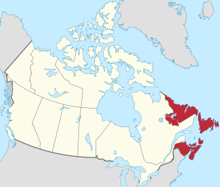
Atlantic Canada, also called the Atlantic provinces, is the region of Eastern Canada comprising the provinces located on the Atlantic coast, excluding Quebec. The four provinces are New Brunswick, Newfoundland and Labrador, Nova Scotia, and Prince Edward Island. As of 2021, the landmass of the four Atlantic provinces was approximately 488,000 km2 (188,000 sq mi), and had a population of over 2.4 million people. The provinces combined had an approximate GDP of $121.888 billion in 2011. The term Atlantic Canada was popularized following the admission of Newfoundland as a Canadian province in 1949.

<span class="mw-page-title-main">Ottawa River</span> River in Canada

The Ottawa River is a river in the Canadian provinces of Ontario and Quebec. It is named after the Algonquin word 'to trade', as it was the major trade route of Eastern Canada at the time. For most of its length, it defines the border between these two provinces. It is a major tributary of the St. Lawrence River and the longest river in Quebec.

<span class="mw-page-title-main">Gatineau</span> City in Quebec, Canada

Gatineau is a city in southwestern Quebec, Canada. It is located on the northern bank of the Ottawa River, immediately across from Ottawa, Ontario. Gatineau is the largest city in the Outaouais administrative region of Quebec and is also part of Canada's National Capital Region. As of 2021, Gatineau is the fourth-largest city in Quebec with a population of 291,041, and it is part of the Ottawa-Gatineau census metropolitan area with a population of 1,488,307 making it the fourth largest in Canada.

<span class="mw-page-title-main">Greater Toronto Area</span> Metropolitan area in Ontario, Canada

The Greater Toronto Area, commonly referred to as the GTA, includes the City of Toronto and the regional municipalities of Durham, Halton, Peel, and York. In total, the region contains 25 urban, suburban, and rural municipalities. The Greater Toronto Area begins in Burlington in Halton Region to the west, and extends along Lake Ontario past downtown Toronto eastward to Clarington in Durham Region.

<span class="mw-page-title-main">Moosonee</span> Town in Ontario, Canada

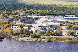
Moosonee is a town in northern Ontario, Canada, on the Moose River approximately 19 km (12 mi) south of James Bay. It is considered to be "the Gateway to the Arctic" and has Ontario's only saltwater port. Nearby on Moose Factory Island is the community of Moose Factory to which it is connected by water taxi in the summer and ice road in the winter.

<span class="mw-page-title-main">Rouyn-Noranda</span> City in Quebec, Canada

Rouyn-Noranda is a city on Osisko Lake in the Abitibi-Témiscamingue region of Quebec, Canada.

<span class="mw-page-title-main">Maniwaki</span> City in Quebec, Canada

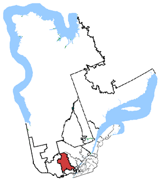
Maniwaki is a town in the province of Quebec, Canada. It is situated 130 kilometres (81 mi) north of Ottawa, Ontario, on the Gatineau River, at the crossroads of Route 105 and Route 107, near Route 117. The town is the administrative centre for La Vallée-de-la-Gatineau Regional County Municipality.

<span class="mw-page-title-main">Census geographic units of Canada</span> Term used in Canada

The census geographic units of Canada are the census subdivisions defined and used by Canada's federal government statistics bureau Statistics Canada to conduct the country's quinquennial census. These areas exist solely for the purposes of statistical analysis and presentation; they have no government of their own. They exist on four levels: the top-level (first-level) divisions are Canada's provinces and territories; these are divided into second-level census divisions, which in turn are divided into third-level census subdivisions and fourth-level dissemination areas.

<span class="mw-page-title-main">Population of Canada</span>

Canada ranks 37th by population among countries of the world, comprising about 0.5% of the world's total, with more than 40 million Canadians as of 2024. Despite being the second-largest country by total area, the vast majority of the country is sparsely inhabited, with most of its population south of the 55th parallel north. Just over 60 percent of Canadians live in just two provinces: Ontario and Quebec. Though Canada's overall population density is low, many regions in the south, such as the Quebec City–Windsor Corridor, have population densities higher than several European countries. Canada has six population centres with more than one million people: Toronto, Montreal, Vancouver, Calgary, Edmonton and Ottawa.

<span class="mw-page-title-main">Laurentides—Labelle</span> Federal electoral district in Quebec, Canada

Laurentides—Labelle is a federal electoral district in Quebec, Canada, that has been represented in the House of Commons of Canada since 2004.

<span class="mw-page-title-main">National Capital Region (Canada)</span> Metropolitan area in Canada

The National Capital Region (NCR), also known as Canada's Capital Region and Ottawa–Gatineau, is an official federal designation encompassing the Canadian capital of Ottawa, Ontario, the adjacent city of Gatineau, Quebec, and surrounding suburban and exurban areas. Despite its designation, the NCR is not a separate political or administrative entity and falls within the provinces of Ontario and Quebec.

Lebanese Canadians are Canadians of Lebanese origin. According to the 2016 census there were 219,555 Canadians who claimed Lebanese ancestry, showing an increase compared to the 2006 census, making them by far the largest group of people with Arabic-speaking roots. As of the 2016 census, they are also one of the largest communities of Asian origin in the country.

<span class="mw-page-title-main">Low, Quebec</span> Township municipality in Quebec, Canada

Low is a township municipality in the La Vallée-de-la-Gatineau Regional County Municipality of western Quebec, Canada. It is situated along the Gatineau River north of Wakefield, and it is located within Canada's National Capital Region. Its 2021 population was 1,020.

<span class="mw-page-title-main">Demographics of Ontario</span>

Ontario, one of the 13 provinces and territories of Canada, is located in east-central Canada. It is Canada's most populous province by a large margin, accounting for nearly 40 percent of all Canadians, and is the second-largest province in total area. Ontario is fourth-largest in total area when the territories of the Northwest Territories and Nunavut are included. It is home to the nation's capital city, Ottawa, and the nation's most populous city, Toronto.

Qikiqtaaluk, Unorganized in Nunavut, Canada, is part of a larger census division known as the Qikiqtaaluk Region. This area covers the whole Qikiqtaaluk Region outside the 13 communities such as Iqaluit, Resolute or Grise Fiord. Baffin has a rocky mountainous landscape. Prior to the 2021 Canadian census it was known as Baffin.

<span class="mw-page-title-main">Greater Madawaska</span> Township municipality in Ontario, Canada

Greater Madawaska is an incorporated township in Renfrew County in eastern Ontario, Canada, created on January 1, 2001, through the amalgamation of the Township of Bagot and Blythfield; the Township of Brougham; and the Township of Griffith and Matawatchan. As of 2011, it has a population of 2,518.

<span class="mw-page-title-main">Aumond</span> Township municipality in Quebec, Canada

Aumond is a township municipality in the Canadian province of Quebec, located within La Vallée-de-la-Gatineau Regional County Municipality.

References

  1. 1 2 3 4 5 6 7 8 "Population and dwelling counts: Canada, provinces and territories". Statistics Canada. 2 September 2022. Archived from the original on 11 April 2023. Retrieved 7 October 2023.
  2. 1 2 3 "Ontario's provincial symbols". Government of Canada, Department of Canadian Heritage. 15 August 2017. Archived from the original on 2 June 2023. Retrieved 7 October 2023.
  3. 1 2 3 "Quebec's provincial symbols". Government of Canada, Department of Canadian Heritage. 15 August 2017. Archived from the original on 29 May 2023. Retrieved 7 October 2023.
  4. "Discover Canada - Canada's Regions". Government of Canada, Immigration, Refugees and Citizenship Canada. 1 July 2012. Archived from the original on 6 August 2023. Retrieved 7 October 2023.
  5. Constitutional Act of 1791, Act of Union 1840, British North America Acts (1867)
  6. "Meet in the middle: Centre of Canada park opens in RM of Taché, Man". CBC News. 17 August 2021. Archived from the original on 16 August 2022. Retrieved 7 October 2023.
  7. "The Atlas of Canada - Frequently Asked Questions About Canada". 16 February 2010. Archived from the original on 22 January 2013. Retrieved 7 October 2023.
  8. Institut de la statistique du Québec. "Comparaison entre la superficie du Québec et celle de divers pays" [Comparison between the area of Quebec and various countries] (in French). Government of Quebec. Archived from the original on 8 August 2011. Retrieved 4 July 2011.
  9. "Natural History of Quebec". A description of the natural history of the province. McGill University. Archived from the original on 6 July 2011. Retrieved 22 June 2011.
  10. "Mont D'Iberville, Québec/Newfoundland". PeakBagger. 1 November 2004. Archived from the original on 7 August 2011.
  11. 1 2 Ministry of Environment of Quebec 2002, p. 5.
  12. Babin 1986, p. 39.
  13. Boyer, Marcel (12 January 2008). "11 idées pour changer le Québec". Le Journal de Montréal (in French). Archived from the original on 25 March 2012.
  14. Commission de toponymie du Québec. "Réservoir de Caniapiscau" (in French). Government of Quebec. Archived from the original on 20 September 2011. Retrieved 10 July 2010.
  15. "Protected areas in Quebec". Ministry of Sustainable Development, Environment, Wildlife and Parks. Archived from the original on 13 December 2013. Retrieved 7 December 2013.
  16. "Protected areas in Quebec" (PDF). Ministry of Sustainable Development, Environment and Parks. 2009. Retrieved 29 March 2009.
  17. "Register of protected areas". Ministry of Development Sustainable, Environment, Wildlife and Parks. Archived from the original on 13 December 2013. Retrieved 7 December 2013.
  18. 1 2 "Census Profile, 2021 Census of Population - Profile table - Quebec, Ontario, Canada". Statistics Canada. 1 February 2023. Archived from the original on 8 October 2023. Retrieved 8 October 2023.
  19. Elections Canada (12 August 2021). "House of Commons Seat Allocation by Province 2012 to 2022". Archived from the original on 3 January 2022. Retrieved 8 October 2023.
  20. "Census Profile, 2021 Census of Population - Select from a list of geographies, Ontario - Census metropolitan area / Census agglomeration". 3 August 2023. Archived from the original on 1 July 2023. Retrieved 8 October 2023.
  21. "Census Profile, 2021 Census of Population - Select from a list of geographies, Quebec - Census metropolitan area / Census agglomeration". 3 August 2023. Archived from the original on 31 August 2023. Retrieved 8 October 2023.
  22. "Census Profile, 2021 Census of Population - Profile table - Toronto, Ontario - [Census metropolitan area]". 1 February 2023. Archived from the original on 9 October 2023. Retrieved 9 October 2023.
  23. "Census Profile, 2021 Census of Population - Profile table - Montreal, Quebec - [Census metropolitan area]". 1 February 2023. Archived from the original on 9 October 2023. Retrieved 8 October 2023.
  24. "Census Profile, 2021 Census of Population - Profile table - Ottawa - Gatineau, Ontario - [Census metropolitan area]". 1 February 2023. Archived from the original on 9 October 2023. Retrieved 9 October 2023.
  25. "Census Profile, 2021 Census of Population - Profile table - Ottawa - Gatineau (Ontario part), Ontario - [Census metropolitan area]". 1 February 2023. Archived from the original on 9 October 2023. Retrieved 9 October 2023.
  26. "Census Profile, 2021 Census of Population - Profile table - Quebec City, Quebec - [Census metropolitan area]". 1 February 2023. Archived from the original on 9 October 2023. Retrieved 8 October 2023.
  27. "Census Profile, 2021 Census of Population - Profile table - Hamilton, Ontario - [Census metropolitan area]". 1 February 2023. Archived from the original on 9 October 2023. Retrieved 9 October 2023.
  28. "Census Profile, 2021 Census of Population - Profile table - Kitchener - Cambridge – Waterloo, Ontario - [Census metropolitan area]". 1 February 2023. Archived from the original on 9 October 2023. Retrieved 9 October 2023.
  29. "Census Profile, 2021 Census of Population - Profile table - London, Ontario - [Census metropolitan area]". 1 February 2023. Archived from the original on 9 October 2023. Retrieved 9 October 2023.
  30. "Census Profile, 2021 Census of Population - Profile table - St. Catharines - Niagara, Ontario - [Census metropolitan area]". 1 February 2023. Archived from the original on 9 October 2023. Retrieved 9 October 2023.
  31. "Census Profile, 2021 Census of Population - Profile table - Windsor, Ontario - [Census metropolitan area]". 1 February 2023. Archived from the original on 9 October 2023. Retrieved 9 October 2023.
  32. "Census Profile, 2021 Census of Population - Profile table - Oshawa, Ontario - [Census metropolitan area]". 1 February 2023. Archived from the original on 9 October 2023. Retrieved 9 October 2023.
  33. "Census Profile, 2021 Census of Population - Profile table - Ottawa – Gatineau (Quebec part), Quebec - [Census metropolitan area]". 1 February 2023. Archived from the original on 9 October 2023. Retrieved 8 October 2023.
  34. "Census Profile, 2021 Census of Population - Profile table - Sherbrooke, Quebec - [Census metropolitan area]". 1 February 2023. Archived from the original on 9 October 2023. Retrieved 8 October 2023.
  35. "Census Profile, 2021 Census of Population - Profile table - Barrie, Ontario - [Census metropolitan area]". 1 February 2023. Archived from the original on 9 October 2023. Retrieved 9 October 2023.
  36. "Census Profile, 2021 Census of Population - Profile table - Kingston, Ontario - [Census metropolitan area]". 1 February 2023. Archived from the original on 9 October 2023. Retrieved 9 October 2023.
  37. "Census Profile, 2021 Census of Population - Profile table - Greater Sudbury / Grand Sudbury, Ontario - [Census metropolitan area]". 1 February 2023. Archived from the original on 9 October 2023. Retrieved 9 October 2023.
  38. "Census Profile, 2021 Census of Population - Profile table - Guelph, Ontario - [Census metropolitan area]". 1 February 2023. Archived from the original on 9 October 2023. Retrieved 9 October 2023.
  39. "Census Profile, 2021 Census of Population - Profile table - Saguenay, Quebec - [Census metropolitan area]". 1 February 2023. Archived from the original on 9 October 2023. Retrieved 8 October 2023.
  40. "Census Profile, 2021 Census of Population - Profile table - Trois-Rivières, Quebec - [Census metropolitan area]". 1 February 2023. Archived from the original on 9 October 2023. Retrieved 8 October 2023.
  41. "Census Profile, 2021 Census of Population - Profile table - Brantford, Ontario - [Census metropolitan area]". 1 February 2023. Archived from the original on 9 October 2023. Retrieved 9 October 2023.
  42. "Census Profile, 2021 Census of Population - Profile table - Peterborough, Ontario - [Census metropolitan area]". 1 February 2023. Archived from the original on 9 October 2023. Retrieved 9 October 2023.
  43. "Census Profile, 2021 Census of Population - Profile table - Thunder Bay, Ontario - [Census metropolitan area]". 1 February 2023. Archived from the original on 9 October 2023. Retrieved 9 October 2023.
  44. "Census Profile, 2021 Census of Population - Profile table - Belleville - Quinte West, Ontario - [Census metropolitan area]". 1 February 2023. Archived from the original on 9 October 2023. Retrieved 9 October 2023.
  45. "Census Profile, 2021 Census of Population - Profile table - Drummondville, Quebec - [Census metropolitan area]". 1 February 2023. Archived from the original on 9 October 2023. Retrieved 8 October 2023.

Sources