The Bronx is a borough of New York City, coextensive with Bronx County, in the U.S. state of New York. It is south of Westchester County; north and east of the New York City borough of Manhattan, across the Harlem River; and north of the New York City borough of Queens, across the East River. The Bronx is the only New York City borough not primarily located on an island. The Bronx has a land area of 42 square miles (109 km2) and a population of 1,472,654 in the 2020 census. If each borough were ranked as a city, the Bronx would rank as the ninth-most-populous in the U.S. Of the five boroughs, it has the fourth-largest area, fourth-highest population, and third-highest population density. The population density of the Bronx was 32,718.7 inhabitants per square mile (12,632.8/km2) in 2022, the third-highest population density of any county in the United States, behind Manhattan and Brooklyn. With a population that is 54.8% Hispanic as of 2020, it is the only majority-Hispanic county in the Northeastern United States and the fourth-most-populous nationwide.

Battery Park City is a mainly residential 92-acre (37 ha) planned community and neighborhood on the west side of the southern tip of the island of Manhattan in New York City. It is bounded by the Hudson River on the west, the Hudson River shoreline on the north and south, and the West Side Highway on the east. The neighborhood is named for the Battery, formerly known as Battery Park, located directly to the south.

Brooklyn is a borough of New York City. Located on the westernmost end of Long Island, it is coextensive with Kings County in the U.S. state of New York. With 2,736,074 residents as of the 2020 United States census, Kings County is the most populous of the five boroughs of New York City and the most populous county in the State of New York. The population density of Brooklyn was 37,339.9 inhabitants per square mile (14,417.0/km2) in 2022, making it the second-most-densely-populated county in the United States, behind Manhattan, and it had the ninth-highest population of any county nationwide. Were Brooklyn still an independent city, it would be the fourth most populous in the U.S. after the rest of New York City, Los Angeles, and Chicago.
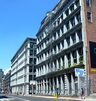
SoHo, sometimes written Soho, is a neighborhood in Lower Manhattan, New York City. Since the 1970s, the neighborhood has been the location of many artists' lofts and art galleries, and has also been known for its variety of shops ranging from trendy upscale boutiques to national and international chain store outlets. The area's history is an archetypal example of inner-city regeneration and gentrification, encompassing socioeconomic, cultural, political, and architectural developments.

Tribeca, originally written as TriBeCa, is a neighborhood in Lower Manhattan in New York City. Its name is a syllabic abbreviation of "Triangle Below Canal Street". The "triangle" is bounded by Canal Street, West Street, Broadway, and Chambers Street. By the 2010s, a common marketing tactic was to extend Tribeca's southern boundary to either Vesey or Murray Streets to increase the appeal of property listings.

The Financial District of Lower Manhattan, also known as FiDi, is a neighborhood located on the southern tip of Manhattan in New York City. It is bounded by the West Side Highway on the west, Chambers Street and City Hall Park on the north, Brooklyn Bridge on the northeast, the East River to the southeast, and South Ferry and the Battery on the south.
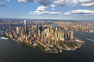
Lower Manhattan, also known as Downtown Manhattan or Downtown New York, is the southernmost part of Manhattan, the central borough of New York City. Lower Manhattan is the core area for business, culture, and municipal government administration. The neighborhood is the historical birthplace of New York City and for its first 225 years was the entirety of the city. It serves as the seat of government of the entire City of New York itself. Because there are no municipally defined boundaries for the neighborhood, a precise population cannot be quoted, but several sources have suggested that it was one of the fastest-growing locations in New York City between 2010 and 2020, related to the influx of young adults and significant development of new housing units.

Bushwick is a neighborhood in the northern part of the New York City borough of Brooklyn. It is bounded by the neighborhood of Ridgewood, Queens, to the northeast; Williamsburg to the northwest; East New York and the cemeteries of Highland Park to the southeast; Brownsville to the south; and Bedford–Stuyvesant to the southwest.

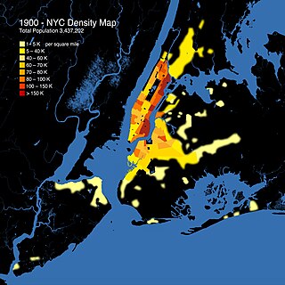
New York City is a large and ethnically diverse metropolis. It is the largest city in the United States with a long history of international immigration. The New York region continues to be by far the leading metropolitan gateway for legal immigrants admitted into the United States. The city is the geographical and demographic center of both the Northeast megalopolis and the New York metropolitan area, the largest metropolitan area in the U.S. by both population and urban area. With over 20.1 million people in its metropolitan statistical area and 23.5 million in its combined statistical area as of 2020, New York City is one of the world's most populous megacities.

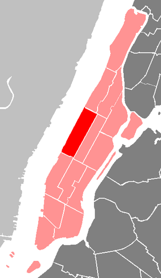
The Manhattan Community Board 3 is a New York City community board encompassing the Manhattan neighborhoods of Alphabet City, the East Village, the Lower East Side, Two Bridges, and a large portion of Chinatown. It is delimited by the East River on the east, the Brooklyn Bridge on the south, Pearl Street, Baxter Street, Canal Street, Bowery and Fourth Avenue on the west, as well as by the 14th Street on the north.

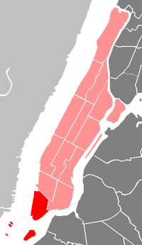
The Manhattan Community Board 2 is a New York City community board encompassing the neighborhoods of Greenwich Village, West Village, South Village, NoHo, SoHo, Little Italy, NoLIta, and a portion of Chinatown in the borough of Manhattan. It is bounded by the Bowery, Canal Street, the Hudson River, and 14th Street on the east, south, west, and north, respectively. The district covers three city council districts and four police precincts, and encompasses one of the largest landmark districts in New York City.
The Manhattan Community Board 7 is a New York City community board encompassing the neighborhoods of Manhattan Valley, Upper West Side, and Lincoln Square in the borough of Manhattan.

The Manhattan Community Board 8 is a New York City community board encompassing the Upper East Side, including the neighborhoods of Lenox Hill, Yorkville, and Roosevelt Island in the borough of Manhattan. It is delimited by the East River on the east, 59th Street on the south, Central Park on the west and 96th Street on the north.

Ocean Hill is a subsection of Bedford–Stuyvesant in the New York City borough of Brooklyn. The neighborhood is part of Brooklyn Community Board 16 and was founded in 1890. The ZIP code for the neighborhood is 11233. Ocean Hill's boundaries start from Broadway and the neighborhood of Bushwick in the north, Ralph Avenue and the neighborhoods of Bedford–Stuyvesant proper and Crown Heights to the west, East New York Avenue and the neighborhood of Brownsville to the south, and Van Sinderen Avenue and the neighborhood of East New York to the east.

Bronx Community Board 3 is a local government unit in the New York City borough, of the Bronx, encompassing the neighborhoods of Crotona Park East, Claremont, Concourse Village, Melrose, and Morrisania. It is delimited by Sheridan Boulevard to the east, the Cross Bronx Expressway and Crotona Park North to the north, Park Avenue and Webster Avenue to the west, and East 159th Street and East 161st Street to the south.

Community boards of Manhattan are New York City community boards in the borough of Manhattan, which are the appointed advisory groups of the community districts that advise on land use and zoning, participate in the city budget process, and address service delivery in their district.

New York County, coterminous with the New York City borough of Manhattan, is the most densely populated U.S. county, with a density of 70,825.6/mi2 (27,267.4/km2) as of 2013. In 1910, it reached a peak of 101,548/mi2 (39,222.9/km2). The county is one of the original counties of New York State.
The Tribeca Trib is a monthly newspaper and website covering Lower Manhattan.
The racial and ethnic history of New York City has varied widely; from its sale to the Dutch by Native American residents, to the modern multi-cultural period.
250 Water Street is a site in the Financial District of Lower Manhattan in New York City. Most recently occupied by a parking lot, the site is being developed into a mixed-use building by the Howard Hughes Corporation. The site is located in the South Street Seaport, one of the city's historic districts.