Bronx Community Board 11

Last updated
Bronx Community District 11
Bronx Community Board 11
CB 11 Bx Colden Av 2022 jeh.jpg
Community Board 11 office
New York City - Bronx Community District 11 HLG.png
Location in The Bronx
CountryFlag of the United States.svg  United States
State Flag of New York.svg  New York
City Flag of New York City.svg New York City
Borough Flag of Bronx County, New York.svg The Bronx
Neighborhoods
Government
  Type Community board
  BodyBronx Community Board 11
  ChairpersonBernadette Ferrara [1]
  District ManagerJeremy Warneke
Area
  Total3.6 sq mi (9 km2)
Population
 (2000)
  Total110,706
  Density31,000/sq mi (12,000/km2)
Ethnicity
  Hispanic and Latino Americans34.63%
  African-American18.1%
  White37.8%
  Asian6.1%
  Others0.6%
  American Indian or Alaska Native0.2%
Time zone UTC−5 (Eastern)
  Summer (DST) UTC−4 (EDT)
ZIP codes
10460, 10461, 10462, 10467, and 10469
Area codes 718, 347, and 929, and 917
Police Precincts49th ( website )
Website www1.nyc.gov/site/bronxcb11/index.page
[2] [3]

Bronx Community Board 11 (CB11) is a small unit of the City of New York (NYC), whose district encompasses the neighborhoods of Allerton, Indian Village, Morris Park, Pelham Gardens, Pelham Parkway (neighborhood), Van Nest and other areas in the borough of the Bronx. Coterminous with the 49th NYPD Precinct, its district is delimited by Bronx Park East and the Bronx River Parkway to the west, Adee Avenue, Boston Road and East Gun Hill Road to the north, the Hutchinson River Parkway to the east, and East Tremont Avenue to the south. [4]

Contents

Board's role and structure

Like the 58 other NYC community boards, CB11 consists of up to 50 volunteers appointed by the Borough President, although at least one half of the board's membership is selected from nominees of the district's respective Council Members. [5] Consisting of several committees, CB11 is headed by an executive board, which consists of a chair, first vice chair, second vice chair, treasurer, secretary, and sergeant at arms. [6]

The board plays an advises on land-use and rezoning matters. It is responsible for identifying community needs as part of the city's budget process and working with government agencies to coordinate and improve the delivery of municipal services. The board also handles special projects, including organizing and working with tenants', homeowners' and merchants' associations, developing graffiti removal, other cleanup projects, and other matters relating to the community's general welfare. Full board meetings, which are open to the public, are usually held on the fourth Thursday of the month. [7]

Staff history

District managers

From 1977 until he died in 1988, the board's first district manager was Thomas "Tom" J. Brown. [8] [9]

From 1989 until 1995, Assistant District Manager Thomas "Tom" F. Lucania took over. [8] At the age of seventeen, Lucania, representing Saint Lucy's School, was a member of the board's then-Youth Services Committee before he became a board member for the first time in 1987 and, also in 1987, assistant district manager. [9] [10]

The board's third district manager, John Fratta, retired from CB11 after 15 years of service to the board. Prior to this, Mr. Fratta was a youth coordinator for Bronx CB7 and a clerk at the City Comptroller's Office. Notable achievements during his tenure include the Pelham Parkway reconstruction project, the opening of a New York Public Library branch on Morris Park Avenue, the revamping of zoning regulations to maintain the low-density character of the neighborhood, and establishing community groups to fight crime in Pelham Parkway and Van Nest. [11]

Additionally, Mr. Fratta was successful at making the board office more accessible to the public and surrounding neighborhood. Prior to November 1997, CB11 was located on the eleventh floor of Jacobi Medical Center, which was perceived as an inconvenience to the community. At the time, Fratta cited State Senator Guy Velella as instrumental in moving the community board to its present location on Colden and Morris Park Avenues. [12]

In December 2010, Jeremy H. Warneke, an Iraq War veteran from Illinois, was unanimously selected by the board to succeed Mr. Fratta as the board's fourth district manager. [13] His term began in 2011, [8] and in 2012, with the help of board members, staff and volunteers, he launched the board's first NYC.gov website. Also in 2012, he was allowed to preliminary select the next round of staff members, two immigrants who were hired for their language as well as technical skills. [14] [15]

Civic groups

Operating within the boundaries and with no formal affiliation of or with the board - are many civic associations, which hold public meetings once a month or week throughout the year, excluding some summer or winter months. Their meetings usually feature guests from city, state or federal government offices but are not official events or meetings of the community board. Some groups currently active within the board's very diverse and minority represented district include but are not limited to The Friends of Pelham Parkway, The Citizens of CB11 Demand a Recall Vote, the 49th Precinct Community Council, Allerton Avenue Home Owners & Tenants Association, Morris Park Community Association, Northeast Bronx Association, Pelham Parkway Neighborhood Association and Van Nest Neighborhood Alliance. [16]

Size and demographics

The CB11 district was much smaller prior to 1975. According to the 1970 census, 96.6 percent of the district was white. [15]

In the year 2000, the district had a population of 110,706, up from 97,842 in 1990 and 99,079 in 1980.

From the year 2000, 41,839 (37.8%) were White Nonhispanic. 37,919 (34.63%) were of Hispanic origin. 20,057 (18.1%) were Black/African American Nonhispanic. 6,728 (6.1%) were Asian or Pacific Islander Nonhispanic. 3,213 (2.9%) were of Two or More Races Nonhispanic. 709 (0.6%) were Some Other Race Nonhispanic, and 241 (0.2%) were American Indian or Alaska Native Nonhispanic. [17]

In 2016, more than half of the board members were white and over the age of 50. [18]

Elected officials

Legislative offices which make their presence known in CB11 include City Council Districts 12, 13 and 15, the 78th, 80th, 82nd, 83rd and 87th State Assembly Districts, State Senatorial Districts 32, 33, 34 and 36 and Congressional Districts 14, 15 and 16. [19]

The city council members representing the community district are non-voting, ex officio board members. [20] The council members and their council districts are:

Housing stock

The housing stock throughout the community board is quite varied. The area around Pelham Parkway for example has a large number of multi-family buildings or apartments in comparison to the number of one and two family homes. Many of the buildings on Bronx Park East both north and south of Pelham Parkway are designed in the Art Deco/Art Moderne style.

Bronx Park East and Reiss Place BronxPkE ReissPl223 2011.JPG
Bronx Park East and Reiss Place

Housing in areas such as Van Nest and Morris Park, generally tend to have more one and two family homes with high concentrations of apartment or multi-family buildings on White Plains and Williamsbridge Roads, respectively.

Related Research Articles

<span class="mw-page-title-main">Throggs Neck</span> Neighborhood of the Bronx in New York City

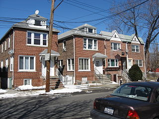
Throggs Neck is a neighborhood and peninsula in the south-eastern portion of the borough of the Bronx in New York City. It is bounded by the East River and Long Island Sound to the south and east, Westchester Creek on the west, and Baisley Avenue and the Bruckner Expressway on the north.

<span class="mw-page-title-main">Pelham Bay (neighborhood), Bronx</span> Neighborhood of the Bronx in New York City

Pelham Bay is a middle class residential neighborhood in the borough of the Bronx, in New York City. It is named for Pelham Bay Park, New York City's largest park, which lies on the neighborhood's northeastern border; and for Pelham Bay, a body of water in that park. The neighborhood is bounded roughly by Pelham Parkway on the north, the New England Thruway (I-95) on the east, the Bruckner Expressway (I-95) on the south, and the Hutchinson River Parkway on the west.

Baychester is a neighborhood geographically located in the northeast part of the Bronx, New York City. Its boundaries are East 222nd Street to the northeast, the New England Thruway (I-95) to the east, Gun Hill Road to the southwest, and Boston Road to the northwest. Eastchester Road is the primary thoroughfare through Baychester.

Pelham Gardens is a neighborhood located in the Northeast section of the Bronx, New York City. Its boundaries, starting from the north and moving clockwise are East Gun Hill Road to the north and east, Pelham Parkway to the south, and the IRT Dyre Avenue Line to the west ending at the esplanade. Eastchester Road is the primary thoroughfare through Pelham Gardens.

Allerton is a working-class neighborhood geographically located in the East Bronx section of the Bronx, New York City. It is named in honor of Daniel Allerton, an early Bronx settler who purchased and farmed this area with his wife Hustace. It consists of two subsections called Bronxwood and Laconia. Its boundaries, starting from the north and moving clockwise, are Adee Avenue, Boston Road, and Gun Hill Road to the northeast; the IRT Dyre Avenue Line to the east; Waring Avenue to the south; and Bronx River Parkway to the west. White Plains Road and Boston Road are the primary thoroughfares through Allerton.

<span class="mw-page-title-main">Bronx Community Board 1</span> Community District in New York, United States

Bronx Community Board 1 is a local government unit of the city of New York, encompassing the neighborhoods of Mott Haven, Melrose, and Port Morris in the borough of the Bronx. It is delimited by the East River, East 149th Street, and Prospect Avenue on the east, East 161st Street, East 159th Street, and East 149th Street on the north, and the Harlem River and Bronx Kill on the west and south.

<span class="mw-page-title-main">Morris Park, Bronx</span> Neighborhood of the Bronx in New York City

Morris Park is a neighborhood in the New York City borough of the Bronx. Its approximate boundaries, starting from the north and moving clockwise, are Neill Avenue and Pelham Parkway to the north, Eastchester Road to the east, the Amtrak Northeast Corridor tracks and Sackett Avenue to the east and south, and Bronxdale Avenue and White Plains Road to the west. It borders the neighborhoods of Van Nest to its southwest and Pelham Parkway to its northeast. Williamsbridge Road and Morris Park Avenue are the primary thoroughfares.

<span class="mw-page-title-main">Van Nest, Bronx</span> Neighborhood of the Bronx in New York City

Van Nest is a working-class neighborhood geographically located in the East Bronx section of the Bronx, New York City. Going clockwise, its boundaries are Bronxdale Avenue to the northeast, the Amtrak tracks to the southeast, and Bronx Park to the west. Van Nest predated Morris Park by 20 years and is considered the older of the two communities. Morris Park Avenue and White Plains Road are the primary commercial thoroughfares through Van Nest.

<span class="mw-page-title-main">Bronx Community Board 3</span> Community District in New York, United States

Bronx Community Board 3 is a local government unit in the New York City borough, of the Bronx, encompassing the neighborhoods of Crotona Park East, Claremont, Concourse Village, Melrose, and Morrisania. It is delimited by Sheridan Boulevard to the east, the Cross Bronx Expressway and Crotona Park North to the north, Park Avenue and Webster Avenue to the west, and East 159th Street and East 161st Street to the south.

<span class="mw-page-title-main">Bronx Community Board 10</span> Community District in New York, United States

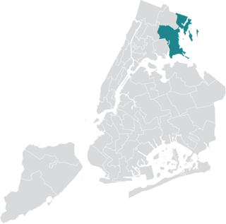
Bronx Community Board 10 is a local government unit of the New York City borough of the Bronx, encompassing the neighborhoods of City Island, Co-op City, Pelham Bay, Throggs Neck and Westchester Square. It is delimited by the Hutchinson River and Pelham Bay Park to the east, New England Thruway, Hutchinson River Parkway, and Westchester Creek to the west, the Bronx/Westchester County Line to the north and the East River to the south.

<span class="mw-page-title-main">Pelham Parkway (neighborhood), Bronx</span> Neighborhood of the Bronx in New York City

Pelham Parkway is a working- and middle-class residential neighborhood geographically located in the center of the Bronx, a borough of New York City in the United States. Its boundaries, starting from the north and moving clockwise are: Waring Avenue to the north, the IRT Dyre Avenue Line tracks to the east, Neill Avenue to the South, and Bronx River Parkway to the west. White Plains Road is the primary commercial thoroughfare through Pelham Parkway. The neighborhood is named after Pelham Parkway, a major west–east parkway that travels through the East Bronx.

<span class="mw-page-title-main">Community boards of Manhattan</span>

Community boards of Manhattan are New York City community boards in the borough of Manhattan, which are the appointed advisory groups of the community districts that advise on land use and zoning, participate in the city budget process, and address service delivery in their district.

<span class="mw-page-title-main">James Vacca</span> American politician

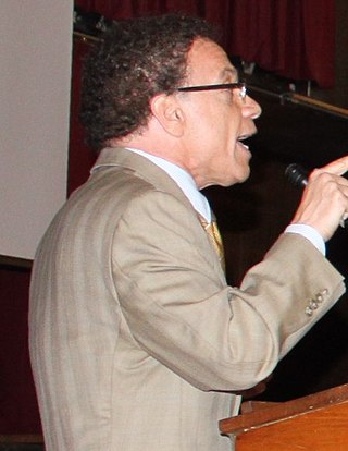
James Vacca is an American politician who served in the New York City Council from the 13th district from 2006 to 2017. He is a Democrat.

<span class="mw-page-title-main">Community boards of Queens</span>

Community boards of Queens are New York City community boards in the borough of Queens, which are the appointed advisory groups of the community districts that advise on land use and zoning, participate in the city budget process, and address service delivery in their district.

<span class="mw-page-title-main">Community boards of the Bronx</span>

Community boards of the Bronx are the 12 New York City community boards in the borough of the Bronx, which are the appointed advisory groups of the community districts that advise on land use and zoning, participate in the city budget process, and address service delivery in their district.

<span class="mw-page-title-main">Schuylerville, Bronx</span> Neighborhood of the Bronx in New York City

Schuylerville is a middle-class neighborhood located in the East Bronx area of New York City. Housing is mostly single-family and two-family houses. It is located next to other middle-to-upper-class residential neighborhoods of Country Club and Pelham Bay.

<span class="mw-page-title-main">Westchester Square, Bronx</span> Neighborhood of the Bronx in New York City

Westchester Square is a residential neighborhood geographically located in the eastern section of the New York City borough of the Bronx. Its boundaries, starting from the north and moving clockwise are: East Tremont Avenue and Silver Street, Blondell Avenue and Westchester Creek to the east, Waterbury Avenue to the south and Castle Hill Avenue to the west. The main roadways through Westchester Square are East Tremont Avenue, Westchester Avenue and Williamsbridge Road.

Esplanade, also known as Esplanade Avenue, is a 0.8-mile (1.3 km) street with a series of green traffic medians in the Morris Park and Pelham Gardens neighborhoods of the Bronx in New York City. The street was constructed in 1912 atop a covered trench of the New York, Westchester and Boston Railway that was cut through a hill. Atop the hill, Esplanade intersects with Pelham Parkway, a road with its own series of green traffic medians designated as parkland.

<span class="mw-page-title-main">New York City's 13th City Council district</span> Place

New York City's 13th City Council district is one of 51 districts in the New York City Council. It is currently represented by Republican Kristy Marmorato following her victory over then-incumbent Marjorie Velázquez in 2023.

References

  1. "Board Members". Bronx Community Board 11. The City of New York. Retrieved July 7, 2023.
  2. "NYC Planning | Community Profiles". communityprofiles.planning.nyc.gov. Retrieved April 17, 2018.
  3. "bx11_profile.pdf" (PDF). docs.google.com. NYC Department of Planning. Retrieved April 17, 2018.
  4. "About CB11". Bronx Community Board 11. The City of New York. Retrieved 2016-03-03.
  5. "About Community Boards: Board Composition & Membership". Mayor's Community Affairs Unit. The City of New York. Archived from the original on 2015-04-09. Retrieved 2016-03-03.
  6. "About CB11: Board Members". Bronx Community Board 11. The City of New York. Retrieved 2016-03-03.
  7. "Mayor's Community Affairs Unit". Community Affairs Unit. Archived from the original on 2011-04-01. Retrieved 2011-02-26.
  8. 1 2 3 "Board Member, Staff & Office Location: Board Staff, 1977 – Present". Bronx Community Board 11. The City of New York. Retrieved 2016-03-03.
  9. 1 2 Goldstein, Lewis H. (June 20, 2015). "Youth Member Seated as Community Board 10 Holds Elections". The Bronx Chronicle. Retrieved 2016-03-03.
  10. "Board Member, Staff & Office Location: Board Members, 1974 – Present". Bronx Community Board 11. The City of New York. Retrieved 2016-03-03.
  11. Mitchell, Max (February 13, 2011). "CB 11 district manager John Fratta steps down". Bronx Times Reporter. Retrieved 2011-02-13.
  12. Marinaccio, J. (November 13, 1997). "CB 11 moves to new district office". The Bronx Times Reporter.
  13. Beekman, Daniel (December 30, 2010). "Community board 11 gains fresh face Jeremy Warneke to solve problems for residents". The New York Daily News. Retrieved 2011-01-27.
  14. "District Manager Jeremy H. Warneke's Bio". Bronx Community Board 11. The City of New York. Retrieved 2017-08-21.
  15. 1 2 Sanchez, Kirsten (August 14, 2013). "CB 11 diversifies". Bronx Times. Retrieved 2016-03-04.
  16. "Community Groups/Organizations". Bronx Community Board 11. The City of New York. Retrieved 2016-03-03.
  17. "BRONX COMMUNITY DISTRICT 11" (SHTML). New York City Department of City Planning. Retrieved 2011-02-11.
  18. Kilgannon, Corey (January 29, 2016). "Greater Diversity Sought for New York City's Community Boards". The New York Times. Retrieved 2016-03-05.
  19. "Elected Officials". Bronx Community Board 11. The City of New York. Retrieved 2016-03-03.
  20. New York City Charter § 2800(a)