Community boards of Staten Island

Last updated
Map of community districts in the City of New York New York City community districts.svg
Map of community districts in the City of New York

Community boards of Staten Island are New York City community boards in the borough of Staten Island, which are the appointed advisory groups of the community districts that advise on land use and zoning, participate in the city budget process, and address service delivery in their district. [1]

Contents

Community boards are each composed of up to 50 volunteer members appointed by the local borough president, half from nominations by City Council members representing the community district (i.e., whose council districts cover part of the community district). [2] [3] Additionally, all City Council members representing the community district are non-voting, ex officio board members. [3]

History

The 1963 revision of the New York City Charter extended the Borough of Manhattan's "Community Planning Councils" (est. 1951) to the outer boroughs as "Community Planning Boards", which are now known as "Community Boards". [4] [5]

The 1975 revision of the New York City Charter set the number of Community Districts/Boards to 59, established the position of the district manager for the community districts, and created the Uniform Land Use Review Procedure (ULURP) which gave the community boards the authority to review land use proposals such as zoning actions, and special permits. [4]

Community Districts

BoroughBorough
President (B.P.)
Number of
Districts
Max. number of
B.P. appointees
Max. number of
all appointees
Staten Island Vito Fossella 375150
Community Districts in Staten Island
Community District (CD)Region [6] AreaPop.
Census
2010
Pop./
sq mi
Neighborhoods & areas [7] District Manager [6] NYPD Precinct [7]
Staten Island CD 1 website North Shore 13.5 sq mi (35 km2) [8] 175,756 [9] 13,019 Arlington, northern Castleton Corners, Clifton Concord, Elm Park, Fort Wadsworth, northern Graniteville, Grymes Hill, Livingston, Mariners' Harbor, northern Meiers Corners, New Brighton, Port Ivory, Port Richmond, Randall Manor, Rosebank, St. George, Shore Acres, Silver Lake, Stapleton, Sunnyside, Tompkinsville, West Brighton, Westerleigh, and northern Willowbrook.Joseph Carroll 120th
Staten Island CD 2 website Mid-Island 21.3 sq mi (55 km2) [10] 132,003 [11] 6,197 Arrochar, Staten Island, Bloomfield, Bulls Head, Chelsea, southern Castleton Corners, Dongan Hills, Egbertville, Emerson Hill, southern Graniteville, Grant City, Grasmere, Heartland Village, Midland Beach, New Dorp, New Springville, Oakwood, Ocean Breeze, Old Town, South Beach, Todt Hill, Travis, and southern Willowbrook Debbie Derrico 122nd
Staten Island CD 3 website South Shore 21.5 sq mi (56 km2) [12] 160,209 [13] 7,452 Annadale, Arden Heights, Bay Terrace, Charleston, Eltingville, Great Kills, Greenridge, Huguenot, Pleasant Plains, Prince's Bay, Richmond Valley, Rossville, Tottenville and Woodrow Charlene Wagner 123rd

Staten Island Borough Board

The Staten Island Borough Board is composed of the borough president, New York City Council members whose districts are part of the borough, and the chairperson of each community board in the Staten Island. [14] [15]

The current borough board (as of June 2020) is composed of the 7 members listed in the table below:

The Staten Island Borough Board
AreaTitleMember name [7] Notes
Staten Island Community District 1 ChairpersonNicholas Siclari
Staten Island Community District 2 ChairpersonRobert J. Collegio
Staten Island Community District 3 ChairpersonFrank Morano
City Council District 49 Council member Kamillah Hanks Council district roughly corresponds to the North Shore
City Council District 50 Council member David Carr Council district roughly corresponds to Mid-Island
City Council District 51 Council member Joseph Borelli Council district roughly corresponds to South Shore
Borough of Staten Island Borough President James Oddo

Other areas

Staten Island Community District 95 / Gateway National Recreation Area New York City - Staten Island Community District 95 HLG.png
Staten Island Community District 95 / Gateway National Recreation Area

Within the borough of Staten Island there is one Joint Interest Area (JIA), which is outside of the jurisdiction of individual community districts, and has its own district number. [16] [17] The JIA in Richmond county is:

See also

Related Research Articles

<span class="mw-page-title-main">Brooklyn Community Board 14</span> Community District in New York, United States

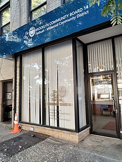
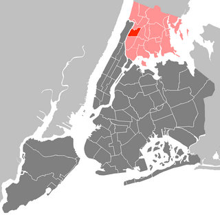
Brooklyn Community Board 14 is a New York City community board that encompasses the Brooklyn neighborhoods of Flatbush, Midwood, Kensington, and Ocean Parkway. It is delimited by Coney Island Avenue, the Long Island Rail Road, McDonald Avenue, Avenue F and 18th Avenue on the west, Parkside Avenue on the north, Bedford Avenue, Foster Avenue and Nostrand Avenue on the east, and Kings Highway and Avenue P on the south.

<span class="mw-page-title-main">Community boards of Brooklyn</span>

Community boards of Brooklyn are New York City community boards in the borough of Brooklyn, which are the appointed advisory groups of the community districts that advise on land use and zoning, participate in the city budget process, and address service delivery in their district.

The Borough president is an elective office in each of the five Boroughs of New York City. For most of the city's history, the office exercised significant executive powers within each borough, and the five borough presidents also sat on the New York City Board of Estimate. Since 1990, the borough presidents have been stripped of a majority of their powers in the government of New York City.

<span class="mw-page-title-main">Bronx Community Board 3</span> Community District in New York, United States

Bronx Community Board 3 is a local government unit in the New York City borough, of the Bronx, encompassing the neighborhoods of Crotona Park East, Claremont, Concourse Village, Melrose, and Morrisania. It is delimited by Sheridan Boulevard to the east, the Cross Bronx Expressway and Crotona Park North to the north, Park Avenue and Webster Avenue to the west, and East 159th Street and East 161st Street to the south.

<span class="mw-page-title-main">Bronx Community Board 9</span> Community District in New York, United States

Bronx Community Board 9 is a local government unit of the city of New York, encompassing the neighborhoods of Castle Hill, Parkchester, Soundview, Harding Park, Bronx River, Clason Point and Unionport. It is delimited by Westchester Creek to the east, Sheridan Boulevard to the west, the Cross Bronx Expressway and East Tremont Avenue to the north and the Bronx River and the East River to the south.

<span class="mw-page-title-main">Bronx Community Board 10</span> Community District in New York, United States

Bronx Community Board 10 is a local government unit of the New York City borough of the Bronx, encompassing the neighborhoods of City Island, Co-op City, Pelham Bay, Throggs Neck and Westchester Square. It is delimited by the Hutchinson River and Pelham Bay Park to the east, New England Thruway, Hutchinson River Parkway, and Westchester Creek to the west, the Bronx/Westchester County Line to the north and the East River to the south.

<span class="mw-page-title-main">Bronx Community Board 12</span> Community District in New York, United States

Bronx Community Board 12 is a local government unit of the New York City borough of the Bronx, encompassing the neighborhoods of Edenwald, Wakefield, Williamsbridge, Woodlawn Heights, Fish Bay, Eastchester, Olinville and Baychester.

<span class="mw-page-title-main">Community boards of Manhattan</span>

Community boards of Manhattan are New York City community boards in the borough of Manhattan, which are the appointed advisory groups of the community districts that advise on land use and zoning, participate in the city budget process, and address service delivery in their district.

The Queens Community Board 2 is a local advisory group in New York City, encompassing the neighborhoods of Hunters Point, Long Island City, Sunnyside, and Woodside, in the borough of Queens. It is delimited by the East River on the west; Bridge Plaza North, the Long Island Rail Road and Northern Boulevard on the north; New York Connecting Railroad on the east; and Newtown Creek on the south.

The Queens Community Board 6 is the local government body in the New York City borough of Queens, encompassing the neighborhoods of Forest Hills and Rego Park. It is delimited by the Horace Harding Expressway to the north, Woodhaven Boulevard to the west, the Jackie Robinson Parkway to the south, and the Grand Central Parkway on the east.

The Queens Community Board 8 is a local government in the New York City borough of Queens, encompassing the neighborhoods of Briarwood, Cunningham Heights, Flushing South, Fresh Meadows, Hillcrest, Hilltop Village, Holliswood, Jamaica Estates, Jamaica Hills, Kew Gardens Hills, Pomonok, and Utopia. It is delimited by the Long Island Expressway to Hillside Avenue and from the Van Wyck Expressway to the Clearview Expressway.

The Queens Community Board 11 is a local government in the New York City borough of Queens, encompassing the neighborhoods of Bayside, Douglaston–Little Neck, Auburndale, East Flushing, Oakland Gardens and Hollis Hills. It is delimited by Utopia Parkway to the west, 26th Avenue and Little Neck Bay to the north, the Nassau County border to the east and Horace Harding Expressway, Clearview Expressway and Grand Central Parkway to the south.

The Queens Community Board 14 is a local government in the New York City borough of Queens, encompassing the neighborhoods of Breezy Point, Belle Harbor, Neponsit, Arverne, Bayswater, Edgemere, Rockaway Park, Rockaway and Far Rockaway. It is bounded to the north by Brooklyn and Jamaica Bay, on the east by the Nassau County border, and to the south by the Atlantic Ocean.

<span class="mw-page-title-main">Community boards of Queens</span>

Community boards of Queens are New York City community boards in the borough of Queens, which are the appointed advisory groups of the community districts that advise on land use and zoning, participate in the city budget process, and address service delivery in their district.

<span class="mw-page-title-main">Community boards of the Bronx</span>

Community boards of the Bronx are the 12 New York City community boards in the borough of the Bronx, which are the appointed advisory groups of the community districts that advise on land use and zoning, participate in the city budget process, and address service delivery in their district.

<span class="mw-page-title-main">Staten Island Community Board 1</span> Community District in New York, United States

Staten Island Community Board 1 is a local government unit of the city of New York, encompassing the Staten Island neighborhoods of Arlington, northern Castleton Corners, Clifton Concord, Elm Park, Fort Wadsworth, northern Graniteville, Grymes Hill, Livingston, Mariners' Harbor, northern Meiers Corners, New Brighton, Port Ivory, Port Richmond, Randall Manor, Rosebank, Staten Island, St. George, Shore Acres, Silver Lake, Stapleton, Sunnyside, Tompkinsville, West New Brighton, Westerleigh, and northern Willowbrook. Community Board 1 is essentially the entire area of Staten Island north of the Staten Island Expressway.

<span class="mw-page-title-main">Staten Island Community Board 2</span> Community District in New York, United States

Staten Island Community Board 2 is a local government unit of the city of New York, encompassing the Staten Island neighborhoods of Arrochar, Bloomfield, Bulls Head, Chelsea, southern Castleton Corners, Dongan Hills, Egbertville, Emerson Hill, southern Graniteville, Grant City, Grasmere, Heartland Village, Midland Beach, New Dorp, New Springville, Oakwood, Ocean Breeze, Old Town, South Beach, Todt Hill, Travis, and southern Willowbrook.

<span class="mw-page-title-main">Staten Island Community Board 3</span> Community District in New York, United States

Staten Island Community Board 3 is a local government unit of the city of New York, encompassing the Staten Island neighborhoods of Annadale, Arden Heights, Bay Terrace, Charleston, Eltingville, Great Kills, Greenridge, Huguenot, Pleasant Plains, Prince's Bay, Richmond Valley, Rossville, Tottenville and Woodrow.

<span class="mw-page-title-main">Community boards of New York City</span> Structures in New York Citys government

The community boards of the New York City government are the appointed advisory groups of the community districts of the five boroughs. There are currently 59 community districts: twelve in the Bronx, eighteen in Brooklyn, twelve in Manhattan, fourteen in Queens, and three in Staten Island.

The New York City Charter is the municipal charter of New York City. As of January 2018, it includes a non-numbered introductory chapter, plus chapters identified by a number or a number plus a letter suffix.

References

  1. Berg, Bruce (2007). New York City Politics: Governing Gotham. Rutgers University Press. p. 277. ISBN   9780813543895.
  2. "About Community Boards". NYC Mayor's Community Affairs Unit. Archived from the original on 9 April 2015. Retrieved 26 November 2016.
  3. 1 2 New York City Charter § 2800(a)
  4. 1 2 Forman, Seth. "Gotham Gazette -- Community Boards". www.gothamgazette.com. Gotham Gazette. Retrieved 16 June 2020.
  5. "Court on Votes". The New York Times. 25 August 1963. Retrieved 18 June 2020.
  6. 1 2 "Local Government". Staten Island USA. Staten Island Borough President's Office. Retrieved 18 June 2020.
  7. 1 2 3 "CAU - Find Your Community Board - Staten Island Community Boards". www.nyc.gov. Retrieved 18 June 2020.
  8. "NYC Planning | Community Profiles 1". communityprofiles.planning.nyc.gov. Retrieved 18 June 2020.
  9. "Staten Island Community District 1 Profile si01_profile.pdf" (PDF). docs.google.com. NYC Planning. Retrieved 18 June 2020.
  10. "NYC Planning | Community Profiles 2". communityprofiles.planning.nyc.gov. Retrieved 18 June 2020.
  11. "Staten Island Community District 2 Profile si02_profile.pdf" (PDF). docs.google.com. NYC Planning. Retrieved 18 June 2020.
  12. "NYC Planning | Community Profiles 3". communityprofiles.planning.nyc.gov. Retrieved 18 June 2020.
  13. "Staten Island Community District 3 Profile si03_profile.pdf" (PDF). docs.google.com. NYC Planning. Retrieved 18 June 2020.
  14. New York City Charter § 85(a)
  15. "Handbook for Community Board Members" (PDF). NYC Mayor’s Community Affairs Unit (CAU). Archived from the original (PDF) on 1 December 2017. Retrieved 29 November 2017.
  16. NYC Department of City Planning. "Joint Interest Areas and Sources & Disclaimer". www1.nyc.gov. Retrieved 21 March 2018.
  17. "2010 Census Table G-1: 2010 Community District Geography Notes" (PDF). Retrieved 11 April 2018.