
Richmondtown is a neighborhood in the Mid-Island section of Staten Island, New York City. It is bounded by Arthur Kill Road on the northwest, Richmond Road on the north, Amboy Road on the east and southeast, and the United Hebrew and Ocean View cemeteries on the southwest.

The South Shore is a geographical term applied to the area in the New York City borough of Staten Island, south and east of the island's ridge of hills along the waterfront and adjacent areas from the Narrows to the mouth of the Arthur Kill. Many observers prefer to restrict its scope to the neighborhoods located between the shoreline of Raritan Bay on one side and Richmond Creek and Fresh Kills on the other, thus encompassing the neighborhoods of Great Kills to Tottenville only. Those who use this narrower definition of the "South Shore" prefer the term "East Shore" for the communities that lie along Lower New York Bay, and inland for approximately 2 to 2½ miles, from Bay Terrace and Richmondtown to as far north as Grasmere and Concord. The South Shore is represented in the New York City Council by Joe Borelli.

Mariners Harbor is a neighborhood located in the northwestern part of New York City's borough of Staten Island. It is bordered by Lake Avenue to the east, Forest Avenue to the south, Richmond Terrace to the north, and Holland Avenue to the west. The northwestern section of Mariners Harbor is often known as Arlington.
Prince's Bay is the name of a neighborhood located on the South Shore of New York City's borough of Staten Island. Prince's Bay is bordered to the north by Huguenot, to the south by the Raritan Bay, and to the west by Pleasant Plains. The neighborhood is represented in the New York State Senate by Andrew Lanza, in the New York State Assembly by Michael Reilly, and in the New York City Council by Joe Borelli.

The term East Shore is frequently applied to a series of neighborhoods along the Lower New York Bay and the Raritan Bay and within New York City's borough of Staten Island.

The term North Shore is frequently applied to a series of neighborhoods within the New York City borough of Staten Island.
Mid-Island is frequently applied to a series of neighborhoods within the New York City borough of Staten Island.
Lemon Creek is a stream located on the South Shore of Staten Island in New York City. It is one of the few remaining ground-level creeks in New York City.

Oakwood is a neighborhood located in east central Staten Island, New York City, near the South Shore. It is bordered by Tysens Lane (north); the Atlantic Ocean (east); Great Kills Park (south); Kensico Street, and Clarke Avenue (west).

Pleasant Plains is a neighborhood located on Staten Island, New York City, New York. It is bordered by Woodrow to the north, the Lower New York Bay to the south, Richmond Valley to the west, and Prince's Bay to the east. The neighborhood is represented in the New York City Council by Joe Borelli.

Rosebank is a neighborhood in northeastern Staten Island, one of New York City's five boroughs. It borders Clifton to the north, Arrochar to the south, and the Upper New York Bay to the east.
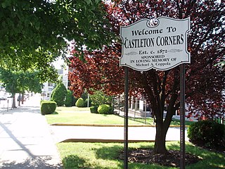
Castleton Corners is an upscale neighborhood of Staten Island, one of the five boroughs of New York City. It is in a region of the island often referred to as the North Shore, Staten Island.
Westerleigh is a residential neighborhood in the northwestern part of Staten Island in New York City.
Willowbrook is a neighborhood in Staten Island, one of the five boroughs of New York City. It is located in the region of the island usually referred to as Mid-Island, immediately to the south of Port Richmond, to the west of Meiers Corners and Westerleigh, to the north of New Springville, and to the east of Bulls Head.
Woodrow is a neighborhood located on the South Shore of Staten Island, New York, United States. The neighborhood is represented in the New York State Senate by Andrew Lanza, in the New York State Assembly by Michael Reilly, and in the New York City Council by Joe Borelli.
Lighthouse Hill is the name of a hill, and the neighborhood situated thereon, in the New York City borough of Staten Island. Lighthouse Hill is situated to the north of Richmondtown, south of Todt Hill, and west of Grant City.
Shore Acres is a neighborhood of Staten Island, one of the five boroughs of New York City. It is situated along the Upper New York Bay, just north of Fort Wadsworth and south of Rosebank. Shore Acres is generally considered to be bounded by Bay Street on the west, the Upper New York Bay on the east, Nautilus Street on the north, and Arthur Von Briesen Park on the south.

Livingston is a name sometimes applied to the northeastern portion of West Brighton, a neighborhood located on the North Shore of the New York City borough of Staten Island.

Tappen Park is a small park and square in the Stapleton neighborhood on the East Shore of Staten Island, New York City. It is bounded by Bay Street on the east, Water Street on the north, and Canal Street on the south and west. It is named for First World War veteran James Tappen. The land that the park is sited on was first purchased by the government in 1867, and it was acquired by the City of New York in 1898.

Bloomingdale Park is a 138-acre (56 ha) park on the South Shore of Staten Island. It is located in the Prince's Bay neighborhood, and is bounded on the north by Ramona Avenue, on the west by Bloomingdale Road, on the east by Lenevar Avenue, and on the south by Drumgoole Road West and the Korean War Veterans Parkway. It is nearly bisected by Maguire Avenue, but the avenue's two spurs into the park from the north and south do not meet in the middle.
