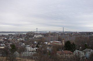
Clifton is a neighborhood on the North Shore of Staten Island in New York City, United States. It is an older waterfront neighborhood, facing Upper New York Bay on the east. It is bordered on the north by Stapleton, on the south by Rosebank, on the southwest by Concord, and on the west by Van Duzer Street.

Mariners Harbor is a neighborhood located in the northwestern part of New York City's borough of Staten Island. It is bordered by Lake Avenue to the east, Forest Avenue to the south, Richmond Terrace to the north, and Holland Avenue to the west. The northwestern section of Mariners Harbor is often known as Arlington.
Prince's Bay is the name of a neighborhood located on the South Shore of New York City's borough of Staten Island. Prince's Bay is bordered to the north by Huguenot, to the south by the Raritan Bay, and to the west by Pleasant Plains. The neighborhood is represented in the New York State Senate by Andrew Lanza, in the New York State Assembly by Michael Reilly, and in the New York City Council by Joe Borelli.

The term North Shore is frequently applied to a series of neighborhoods within the New York City borough of Staten Island.
Mid-Island is frequently applied to a series of neighborhoods within the New York City borough of Staten Island.

Oakwood is a neighborhood located in east central Staten Island, New York City, near the South Shore. It is bordered by Tysens Lane (north); the Atlantic Ocean (east); Great Kills Park (south); Kensico Street, and Clarke Avenue (west).

Travis is a residential and industrial neighborhood in west-central Staten Island, one of the five boroughs of New York City.
Westerleigh is a residential neighborhood in the northwestern part of Staten Island in New York City.

Bulls Head is a neighborhood in west-central Staten Island, one of the five boroughs of New York City. It is bordered by New Springville to the south, Bloomfield to the west, Willowbrook to the east, Graniteville to the north, and Westerleigh to the north.
Willowbrook is a neighborhood in Staten Island, one of the five boroughs of New York City. It is located in the region of the island usually referred to as Mid-Island, immediately to the south of Port Richmond, to the west of Meiers Corners and Westerleigh, to the north of New Springville, and to the east of Bulls Head.
New Springville is a neighborhood in Staten Island, one of the five boroughs of New York City, USA.
Arden Heights is a name increasingly applied to the western part of Annadale, a neighborhood located on the South Shore of Staten Island, New York, USA. The name "Arden Heights" is found on most maps of New York City, including Hagstrom's.
Graniteville is the name of a neighborhood in Staten Island, one of the five boroughs of New York City.

Port Ivory is a coastal area in the northwestern corner of Staten Island, New York City, New York, United States. It is located on Newark Bay near the entrances the Kill van Kull in the east and Arthur Kill in the west. It is bordered by Arlington to the east, Old Place to the south, Newark Bay to the north, and the Arthur Kill to the west.

Livingston is a name sometimes applied to the northeastern portion of West Brighton, a neighborhood located on the North Shore of the New York City borough of Staten Island.
Heartland Village is a residential development located close to the geographic center of Staten Island, one of the five boroughs of New York City, USA. The name is also often used to denote the immediately surrounding area.
Vanderbilt Avenue is the name of three thoroughfares in the New York City boroughs of Brooklyn, Manhattan, and Staten Island. They were named after Cornelius Vanderbilt (1794–1877), the builder of Grand Central Terminal in Midtown Manhattan.

Richmond Avenue is a major north-south thoroughfare on Staten Island, New York. Measuring approximately 7.0 miles (11.3 km), the road runs from the South Shore community of Eltingville to the North Shore community of Graniteville.

Manor Heights is a neighborhood located in Staten Island, New York City. Manor comes from the fact that the neighborhood is adjacent to Manor Road, a major thoroughfare in the North Shore of Staten Island, and Heights due to the area's sudden elevation within its boundaries. The neighborhood's loose boundaries include the areas south of the Staten Island Expressway, north of Brielle Avenue, which is the location of Susan E. Wagner High School, to the west of Manor Road, and to the east of Bradley Avenue.
Arlington is a neighborhood on the North Shore of Staten Island in New York City. It is a subsection of the Mariners' Harbor neighborhood, located north of the North Shore Branch, and west of Harbor Road. Arlington was given its name by Civil War veteran and resident Moses Henry Leman, in recognition of Arlington National Cemetery.

